![](/images/other/stat-length.png)
![Trail Walking Aragnouet - Lac de Barroude par Aragnouet - Photo](https://media.geolcdn.com/t/1900/400/ext.pjpeg?maxdim=2&url=https%3A%2F%2Fservices.sitytrail.com%2FGeolivesWS%2FDownloadMedia.ashx%3FTrailID%3D101308%26Media%3D803_1.jpg)
Lac de Barroude par Aragnouet
tracegps
User
![Length](/images/other/stat-length.png)
Length
8.2 km
![Max alt](https://static1.geolcdn.com/siteimages/upload/files/1508320355ic_sort_altitude_max_24dp.png)
Max alt
2385 m
![Uphill gradient](https://static1.geolcdn.com/siteimages/upload/files/1508320355ic_sort_den_pos_24dp.png)
Uphill gradient
999 m
![Km-Effort](/images/other/stat-length.png)
Km-Effort
18.3 km
![Min alt](https://static1.geolcdn.com/siteimages/upload/files/1508320355ic_sort_altitude_min_24dp.png)
Min alt
1404 m
![Downhill gradient](https://static1.geolcdn.com/siteimages/upload/files/1508320355ic_sort_den_neg_24dp.png)
Downhill gradient
22 m
![Boucle](https://static1.geolcdn.com/siteimages/upload/files/16400158638029165_repeat_loop_refresh_sync_direction_icon.png)
Boucle
No
Creation date :
2014-12-10 00:00:00.0
Updated on :
2014-12-10 00:00:00.0
![Walking](https://static1.geolcdn.com/sitytour/trail-icons/101.png)
3h00
Difficulty : Difficult
![Scan this QR Code to open this trail in the SityTrail application](https://capi.geolives.com/qq0zvz2zws4bq2lad0pu/sitytour/trails/101308/qr.png?size=200)
FREE GPS app for hiking
About
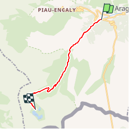
Trail Walking of 8.2 km to be discovered at Occitania, Hautespyrenees, Aragnouet. This trail is proposed by tracegps.
Description
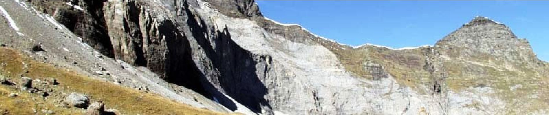
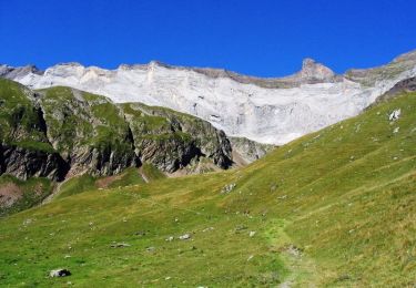
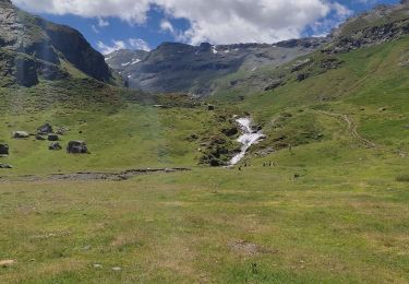
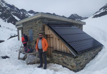
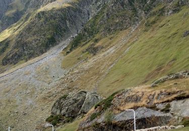
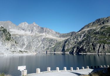
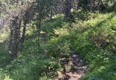
Très agréable circuit jusqu’au refuge en surplomb du lac, marmottes présentes sur la première partie et ensuite les izards restent visibles en ouvrant bien l’oeil. D’autres infos sur le site Rando.eu Photos de Lourdes-Info.com
Positioning
Country:
France
Region :
Occitania
Department/Province :
Hautespyrenees
Municipality :
Aragnouet
Location:
Unknown
Start:(Dec)
Start:(UTM)
270028 ; 4740112 (31T) N.
Comments
Trails nearby
![Trail Walking Aragnouet - Pic d'Estaragne et Pic Cambieil - Photo](https://media.geolcdn.com/t/375/260/ext.jpg?maxdim=2&url=https%3A%2F%2Fservices.sitytrail.com%2FGeolivesWS%2FDownloadMedia.ashx%3FTrailID%3D108155%26Media%3D319_6.jpg)
![Walking Walking](https://static1.geolcdn.com/sitytour/trail-icons/101.png)
Pic d'Estaragne et Pic Cambieil
Walking
Very difficult
(2)
Aragnouet,
Occitania,
Hautespyrenees,
France
![](/images/other/stat-length.png)
11.6 km | 28 km-effort
3h 40min
![](https://static1.geolcdn.com/siteimages/upload/files/16400158638029165_repeat_loop_refresh_sync_direction_icon.png)
Yes
![Trail Walking Aragnouet - Pic Barrosa, Soum Barrosa et Pic de Port de Vieux - Photo](https://media.geolcdn.com/t/375/260/ext.jpg?maxdim=2&url=https%3A%2F%2Fservices.sitytrail.com%2FGeolivesWS%2FDownloadMedia.ashx%3FTrailID%3D109846%26Media%3D4817_1.jpg)
![Walking Walking](https://static1.geolcdn.com/sitytour/trail-icons/101.png)
Pic Barrosa, Soum Barrosa et Pic de Port de Vieux
Walking
Very difficult
(1)
Aragnouet,
Occitania,
Hautespyrenees,
France
![](/images/other/stat-length.png)
22 km | 42 km-effort
9h 0min
![](https://static1.geolcdn.com/siteimages/upload/files/16400158638029165_repeat_loop_refresh_sync_direction_icon.png)
Yes
![Trail Walking Aragnouet - Hourquettes de Héas et de Chermentas en boucle depuis Piau Engaly - Photo](https://media.geolcdn.com/t/375/260/ext.jpg?maxdim=2&url=https%3A%2F%2Fstatic1.geolcdn.com%2Fsiteimages%2Fupload%2Ffiles%2F1553511878bg_sport_marche.png)
![Walking Walking](https://static1.geolcdn.com/sitytour/trail-icons/101.png)
Hourquettes de Héas et de Chermentas en boucle depuis Piau Engaly
Walking
Medium
(3)
Aragnouet,
Occitania,
Hautespyrenees,
France
![](/images/other/stat-length.png)
12.4 km | 25 km-effort
5h 3min
![](https://static1.geolcdn.com/siteimages/upload/files/16400158638029165_repeat_loop_refresh_sync_direction_icon.png)
Yes
![Trail Walking Aragnouet - M005-Circuit Barroude-Port Vieux - Photo](https://media.geolcdn.com/t/375/260/ext.jpg?maxdim=2&url=https%3A%2F%2Fstatic1.geolcdn.com%2Fsiteimages%2Fupload%2Ffiles%2F1553511878bg_sport_marche.png)
![Walking Walking](https://static1.geolcdn.com/sitytour/trail-icons/101.png)
M005-Circuit Barroude-Port Vieux
Walking
Difficult
(1)
Aragnouet,
Occitania,
Hautespyrenees,
France
![](/images/other/stat-length.png)
22 km | 41 km-effort
8h 11min
![](https://static1.geolcdn.com/siteimages/upload/files/16400158638029165_repeat_loop_refresh_sync_direction_icon.png)
Yes
![Trail Walking Aragnouet - Lac du Badet par les cascades - Photo](https://media.geolcdn.com/t/375/260/9daf7969-9693-4faa-b4b4-dab637fac0b9.jpg&format=jpg&maxdim=2)
![Walking Walking](https://static1.geolcdn.com/sitytour/trail-icons/101.png)
Lac du Badet par les cascades
Walking
Medium
Aragnouet,
Occitania,
Hautespyrenees,
France
![](/images/other/stat-length.png)
7.6 km | 12.3 km-effort
2h 35min
![](https://static1.geolcdn.com/siteimages/upload/files/16400158638029165_repeat_loop_refresh_sync_direction_icon.png)
Yes
![Trail Snowshoes Aragnouet - Lac de Badet - Photo](https://media.geolcdn.com/t/375/260/9b2b789d-f7ae-4692-bd77-61891e068d4e.jpg&format=jpg&maxdim=2)
![Snowshoes Snowshoes](https://static1.geolcdn.com/sitytour/trail-icons/504.png)
Lac de Badet
Snowshoes
Medium
Aragnouet,
Occitania,
Hautespyrenees,
France
![](/images/other/stat-length.png)
7.9 km | 12.9 km-effort
3h 26min
![](https://static1.geolcdn.com/siteimages/upload/files/16400158638029165_repeat_loop_refresh_sync_direction_icon.png)
Yes
![Trail Walking Aragnouet - 2023-09-14 Piau Engaly - Hourquette de Heas - Photo](https://media.geolcdn.com/t/375/260/40459c19-74a7-48e3-af16-70359e48c571.jpg&format=jpg&maxdim=2)
![Walking Walking](https://static1.geolcdn.com/sitytour/trail-icons/101.png)
2023-09-14 Piau Engaly - Hourquette de Heas
Walking
Difficult
Aragnouet,
Occitania,
Hautespyrenees,
France
![](/images/other/stat-length.png)
13.3 km | 25 km-effort
5h 28min
![](https://static1.geolcdn.com/siteimages/upload/files/16400158638029165_repeat_loop_refresh_sync_direction_icon.png)
Yes
![Trail Walking Aragnouet - 2023-09-08 Lacs Neouvielle - Photo](https://media.geolcdn.com/t/375/260/a59ce9de-5eea-442c-b992-1dd4a2a4e647.jpg&format=jpg&maxdim=2)
![Walking Walking](https://static1.geolcdn.com/sitytour/trail-icons/101.png)
2023-09-08 Lacs Neouvielle
Walking
Difficult
Aragnouet,
Occitania,
Hautespyrenees,
France
![](/images/other/stat-length.png)
13.9 km | 24 km-effort
5h 55min
![](https://static1.geolcdn.com/siteimages/upload/files/16400158638029165_repeat_loop_refresh_sync_direction_icon.png)
Yes
![Trail Walking Aragnouet - Lac de catchet - Photo](https://media.geolcdn.com/t/375/260/5dfcdd02-79ae-4be5-ba88-3f21c4d48cf0.jpg&format=jpg&maxdim=2)
![Walking Walking](https://static1.geolcdn.com/sitytour/trail-icons/101.png)
Lac de catchet
Walking
Medium
Aragnouet,
Occitania,
Hautespyrenees,
France
![](/images/other/stat-length.png)
4 km | 10.7 km-effort
2h 25min
![](https://static1.geolcdn.com/siteimages/upload/files/16400158638029165_repeat_loop_refresh_sync_direction_icon.png)
Yes
marmottes et Isa