![](/images/other/stat-length.png)
![Trail Walking Castelnaud-la-Chapelle - Les Milandes - St-Cybranet - Photo](https://media.geolcdn.com/t/1900/400/ext.pjpeg?maxdim=2&url=https%3A%2F%2Fservices.sitytrail.com%2FGeolivesWS%2FDownloadMedia.ashx%3FTrailID%3D101307%26Media%3D802_1.jpg)
Les Milandes - St-Cybranet
tracegps
User
![Length](/images/other/stat-length.png)
Length
14.2 km
![Max alt](https://static1.geolcdn.com/siteimages/upload/files/1508320355ic_sort_altitude_max_24dp.png)
Max alt
260 m
![Uphill gradient](https://static1.geolcdn.com/siteimages/upload/files/1508320355ic_sort_den_pos_24dp.png)
Uphill gradient
298 m
![Km-Effort](/images/other/stat-length.png)
Km-Effort
18.3 km
![Min alt](https://static1.geolcdn.com/siteimages/upload/files/1508320355ic_sort_altitude_min_24dp.png)
Min alt
76 m
![Downhill gradient](https://static1.geolcdn.com/siteimages/upload/files/1508320355ic_sort_den_neg_24dp.png)
Downhill gradient
334 m
![Boucle](https://static1.geolcdn.com/siteimages/upload/files/16400158638029165_repeat_loop_refresh_sync_direction_icon.png)
Boucle
No
Creation date :
2014-12-10 00:00:00.0
Updated on :
2014-12-10 00:00:00.0
![Walking](https://static1.geolcdn.com/sitytour/trail-icons/101.png)
3h00
Difficulty : Medium
![Scan this QR Code to open this trail in the SityTrail application](https://capi.geolives.com/qq0zvz2zws4bq2lad0pu/sitytour/trails/101307/qr.png?size=200)
FREE GPS app for hiking
About
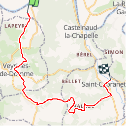
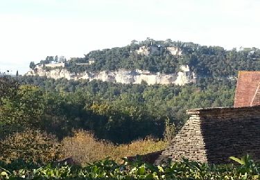
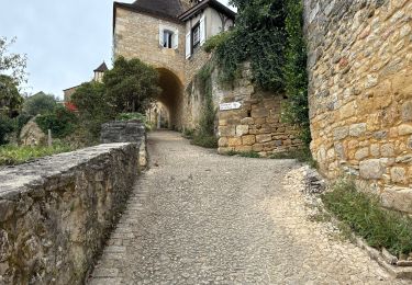
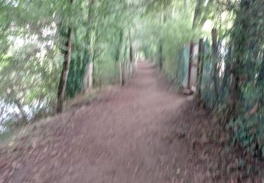
Trail Walking of 14.2 km to be discovered at New Aquitaine, Dordogne, Castelnaud-la-Chapelle. This trail is proposed by tracegps.
Description
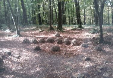
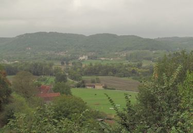
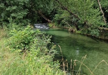
Petite balade linéaire (prévoir le retour) sur les côteaux de la vallée de la Dordogne et du Céou. D’autres infos sur le site Rando.eu Voir le site du Chateau des Milandes
Positioning
Country:
France
Region :
New Aquitaine
Department/Province :
Dordogne
Municipality :
Castelnaud-la-Chapelle
Location:
Unknown
Start:(Dec)
Start:(UTM)
350860 ; 4965021 (31T) N.
Comments
Trails nearby
![Trail Walking Castelnaud-la-Chapelle - Castelnaud 14,5km - Photo](https://media.geolcdn.com/t/375/260/ext.jpg?maxdim=2&url=https%3A%2F%2Fservices.sitytrail.com%2FGeolivesWS%2FDownloadMedia.ashx%3FTrailID%3D1066189%26Media%3Dfix__20181103150326.jpg)
![Walking Walking](https://static1.geolcdn.com/sitytour/trail-icons/101.png)
Castelnaud 14,5km
Walking
Medium
(1)
Castelnaud-la-Chapelle,
New Aquitaine,
Dordogne,
France
![](/images/other/stat-length.png)
14.3 km | 18.3 km-effort
3h 41min
![](https://static1.geolcdn.com/siteimages/upload/files/16400158638029165_repeat_loop_refresh_sync_direction_icon.png)
Yes
![Trail Walking Castelnaud-la-Chapelle - Périgord j2 Castelnaud - Photo](https://media.geolcdn.com/t/375/260/24da01e3-51b4-4959-999d-053c9737dbd0.jpg&format=jpg&maxdim=2)
![Walking Walking](https://static1.geolcdn.com/sitytour/trail-icons/101.png)
Périgord j2 Castelnaud
Walking
Easy
Castelnaud-la-Chapelle,
New Aquitaine,
Dordogne,
France
![](/images/other/stat-length.png)
17.1 km | 24 km-effort
4h 38min
![](https://static1.geolcdn.com/siteimages/upload/files/16400158638029165_repeat_loop_refresh_sync_direction_icon.png)
No
![Trail Walking Vézac - Boucle Beynac- La Roque Gageac - Photo](https://media.geolcdn.com/t/375/260/c8a62bb6-456c-4421-8ac7-a6b4d58db5d2.jpg&format=jpg&maxdim=2)
![Walking Walking](https://static1.geolcdn.com/sitytour/trail-icons/101.png)
Boucle Beynac- La Roque Gageac
Walking
Medium
Vézac,
New Aquitaine,
Dordogne,
France
![](/images/other/stat-length.png)
16.3 km | 22 km-effort
4h 20min
![](https://static1.geolcdn.com/siteimages/upload/files/16400158638029165_repeat_loop_refresh_sync_direction_icon.png)
Yes
![Trail Walking Beynac-et-Cazenac - Perigor Beynac - Photo](https://media.geolcdn.com/t/375/260/a861afd5-735a-473e-a5f1-3f79378bc8ab.jpg&format=jpg&maxdim=2)
![Walking Walking](https://static1.geolcdn.com/sitytour/trail-icons/101.png)
Perigor Beynac
Walking
Medium
Beynac-et-Cazenac,
New Aquitaine,
Dordogne,
France
![](/images/other/stat-length.png)
16.3 km | 22 km-effort
4h 5min
![](https://static1.geolcdn.com/siteimages/upload/files/16400158638029165_repeat_loop_refresh_sync_direction_icon.png)
Yes
![Trail Motor Vézac - Jardin du château de Marquesac - Photo](https://media.geolcdn.com/t/375/260/ext.jpg?maxdim=2&url=https%3A%2F%2Fservices.sitytrail.com%2FGeolivesWS%2FDownloadMedia.ashx%3FTrailID%3D347730%26Media%3Dfix__20140923141715.jpg)
![Motor Motor](https://static1.geolcdn.com/sitytour/trail-icons/400.png)
Jardin du château de Marquesac
Motor
Very difficult
Vézac,
New Aquitaine,
Dordogne,
France
![](/images/other/stat-length.png)
5.3 km | 6.8 km-effort
4h 19min
![](https://static1.geolcdn.com/siteimages/upload/files/16400158638029165_repeat_loop_refresh_sync_direction_icon.png)
Yes
![Trail Walking Castelnaud-la-Chapelle - Balade autour de Castelnaud la Chapelle - Photo](https://media.geolcdn.com/t/375/260/ext.jpg?maxdim=2&url=https%3A%2F%2Fservices.sitytrail.com%2FGeolivesWS%2FDownloadMedia.ashx%3FTrailID%3D172935%26Media%3D14412_3.jpg)
![Walking Walking](https://static1.geolcdn.com/sitytour/trail-icons/101.png)
Balade autour de Castelnaud la Chapelle
Walking
Medium
Castelnaud-la-Chapelle,
New Aquitaine,
Dordogne,
France
![](/images/other/stat-length.png)
13.5 km | 19 km-effort
3h 30min
![](https://static1.geolcdn.com/siteimages/upload/files/16400158638029165_repeat_loop_refresh_sync_direction_icon.png)
Yes
![Trail Walking Vézac - 2011-06-03 - 17h56m53 - Photo](https://media.geolcdn.com/t/375/260/ext.jpg?maxdim=2&url=https%3A%2F%2Fservices.sitytrail.com%2FGeolivesWS%2FDownloadMedia.ashx%3FTrailID%3D67099%26Media%3D20110603154850.jpg)
![Walking Walking](https://static1.geolcdn.com/sitytour/trail-icons/101.png)
2011-06-03 - 17h56m53
Walking
Very easy
(1)
Vézac,
New Aquitaine,
Dordogne,
France
![](/images/other/stat-length.png)
1.2 km | 1.8 km-effort
Unknown
![](https://static1.geolcdn.com/siteimages/upload/files/16400158638029165_repeat_loop_refresh_sync_direction_icon.png)
Yes
![Trail Walking Vézac - Château de Marqueyssac - Photo](https://media.geolcdn.com/t/375/260/b9e15253-79a4-442d-a1c8-a27b8cf42b2d.jpg&format=jpg&maxdim=2)
![Walking Walking](https://static1.geolcdn.com/sitytour/trail-icons/101.png)
Château de Marqueyssac
Walking
Vézac,
New Aquitaine,
Dordogne,
France
![](/images/other/stat-length.png)
3.1 km | 4.1 km-effort
53min
![](https://static1.geolcdn.com/siteimages/upload/files/16400158638029165_repeat_loop_refresh_sync_direction_icon.png)
No
![Trail Hybrid bike Castelnaud-la-Chapelle - Castelnaud à l'abbaye Nouvelle et retour (Dordogne) - Photo](https://media.geolcdn.com/t/375/260/9e35bcb8-43a7-463b-b578-7314281c2612.jpg&format=jpg&maxdim=2)
![Hybrid bike Hybrid bike](https://static1.geolcdn.com/sitytour/trail-icons/203.png)
Castelnaud à l'abbaye Nouvelle et retour (Dordogne)
Hybrid bike
Very difficult
Castelnaud-la-Chapelle,
New Aquitaine,
Dordogne,
France
![](/images/other/stat-length.png)
53 km | 62 km-effort
6h 19min
![](https://static1.geolcdn.com/siteimages/upload/files/16400158638029165_repeat_loop_refresh_sync_direction_icon.png)
Yes