![](/images/other/stat-length.png)
![Trail Walking Beyrède-Jumet-Camous - Signal de Bassia de Hèche - Photo](https://media.geolcdn.com/t/1900/400/ext.pjpeg?maxdim=2&url=https%3A%2F%2Fservices.sitytrail.com%2FGeolivesWS%2FDownloadMedia.ashx%3FTrailID%3D101301%26Media%3D796_2.jpg)
Signal de Bassia de Hèche
tracegps
User
![Length](/images/other/stat-length.png)
Length
3.1 km
![Max alt](https://static1.geolcdn.com/siteimages/upload/files/1508320355ic_sort_altitude_max_24dp.png)
Max alt
1901 m
![Uphill gradient](https://static1.geolcdn.com/siteimages/upload/files/1508320355ic_sort_den_pos_24dp.png)
Uphill gradient
505 m
![Km-Effort](/images/other/stat-length.png)
Km-Effort
8.2 km
![Min alt](https://static1.geolcdn.com/siteimages/upload/files/1508320355ic_sort_altitude_min_24dp.png)
Min alt
1421 m
![Downhill gradient](https://static1.geolcdn.com/siteimages/upload/files/1508320355ic_sort_den_neg_24dp.png)
Downhill gradient
29 m
![Boucle](https://static1.geolcdn.com/siteimages/upload/files/16400158638029165_repeat_loop_refresh_sync_direction_icon.png)
Boucle
No
Creation date :
2014-12-10 00:00:00.0
Updated on :
2014-12-10 00:00:00.0
![Walking](https://static1.geolcdn.com/sitytour/trail-icons/101.png)
3h30
Difficulty : Very difficult
![Scan this QR Code to open this trail in the SityTrail application](https://capi.geolives.com/qq0zvz2zws4bq2lad0pu/sitytour/trails/101301/qr.png?size=200)
FREE GPS app for hiking
About
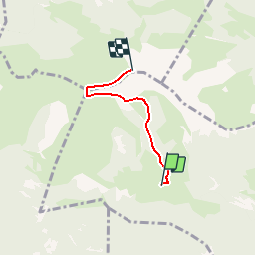
Trail Walking of 3.1 km to be discovered at Occitania, Hautespyrenees, Beyrède-Jumet-Camous. This trail is proposed by tracegps.
Description
Un belvédère exceptionnel sur les vallées d'Adour et d'Aure. Toutes les descriptions sont sur Montagne Cool Topo présenté par lolo6579
Positioning
Country:
France
Region :
Occitania
Department/Province :
Hautespyrenees
Municipality :
Beyrède-Jumet-Camous
Location:
Beyrède-Jumet
Start:(Dec)
Start:(UTM)
280513 ; 4760211 (31T) N.
Comments
Trails nearby
![Trail Walking Esparros - Du Signal de Bassia vers le col de Beyrède par la crête sud-est et le Pas de Bassia - Photo](https://media.geolcdn.com/t/375/260/ext.jpg?maxdim=2&url=https%3A%2F%2Fstatic1.geolcdn.com%2Fsiteimages%2Fupload%2Ffiles%2F1553511878bg_sport_marche.png)
![Walking Walking](https://static1.geolcdn.com/sitytour/trail-icons/101.png)
Du Signal de Bassia vers le col de Beyrède par la crête sud-est et le Pas de ...
Walking
Medium
(9)
Esparros,
Occitania,
Hautespyrenees,
France
![](/images/other/stat-length.png)
3.2 km | 5.1 km-effort
48min
![](https://static1.geolcdn.com/siteimages/upload/files/16400158638029165_repeat_loop_refresh_sync_direction_icon.png)
No
![Trail Walking Ancizan - Vallée de la Gaoube - Photo](https://media.geolcdn.com/t/375/260/e9b5d96b-48c0-4d82-9142-57559dc5c2b3.jpg&format=jpg&maxdim=2)
![Walking Walking](https://static1.geolcdn.com/sitytour/trail-icons/101.png)
Vallée de la Gaoube
Walking
Medium
(1)
Ancizan,
Occitania,
Hautespyrenees,
France
![](/images/other/stat-length.png)
6.6 km | 9.1 km-effort
4h 49min
![](https://static1.geolcdn.com/siteimages/upload/files/16400158638029165_repeat_loop_refresh_sync_direction_icon.png)
Yes
![Trail On foot Campan - Boucle d'Espiadet - Photo](https://media.geolcdn.com/t/375/260/0625399b-d0a9-424d-94f3-d72094f23909.jpeg&format=jpg&maxdim=2)
![On foot On foot](https://static1.geolcdn.com/sitytour/trail-icons/100.png)
Boucle d'Espiadet
On foot
Easy
Campan,
Occitania,
Hautespyrenees,
France
![](/images/other/stat-length.png)
4.2 km | 6.3 km-effort
1h 25min
![](https://static1.geolcdn.com/siteimages/upload/files/16400158638029165_repeat_loop_refresh_sync_direction_icon.png)
No
![Trail Walking Beyrède-Jumet-Camous - Le signal de Bassia depuis le col de Beyrède - Photo](https://media.geolcdn.com/t/375/260/ext.jpg?maxdim=2&url=https%3A%2F%2Fstatic1.geolcdn.com%2Fsiteimages%2Fupload%2Ffiles%2F1553511878bg_sport_marche.png)
![Walking Walking](https://static1.geolcdn.com/sitytour/trail-icons/101.png)
Le signal de Bassia depuis le col de Beyrède
Walking
Medium
(3)
Beyrède-Jumet-Camous,
Occitania,
Hautespyrenees,
France
![](/images/other/stat-length.png)
4.1 km | 10.3 km-effort
1h 53min
![](https://static1.geolcdn.com/siteimages/upload/files/16400158638029165_repeat_loop_refresh_sync_direction_icon.png)
Yes
![Trail Walking Campan - Pic de Bassia, Pic du Castillon, Pic de Paou - Photo](https://media.geolcdn.com/t/375/260/ext.jpg?maxdim=2&url=https%3A%2F%2Fstatic1.geolcdn.com%2Fsiteimages%2Fupload%2Ffiles%2F1553511878bg_sport_marche.png)
![Walking Walking](https://static1.geolcdn.com/sitytour/trail-icons/101.png)
Pic de Bassia, Pic du Castillon, Pic de Paou
Walking
Very easy
(1)
Campan,
Occitania,
Hautespyrenees,
France
![](/images/other/stat-length.png)
10.3 km | 22 km-effort
3h 52min
![](https://static1.geolcdn.com/siteimages/upload/files/16400158638029165_repeat_loop_refresh_sync_direction_icon.png)
No
![Trail Snowshoes Campan - raquet 1 - Photo](https://media.geolcdn.com/t/375/260/ext.jpg?maxdim=2&url=https%3A%2F%2Fstatic1.geolcdn.com%2Fsiteimages%2Fupload%2Ffiles%2F1524743153raquette.jpg)
![Snowshoes Snowshoes](https://static1.geolcdn.com/sitytour/trail-icons/504.png)
raquet 1
Snowshoes
Easy
(1)
Campan,
Occitania,
Hautespyrenees,
France
![](/images/other/stat-length.png)
4.9 km | 7.2 km-effort
2h 10min
![](https://static1.geolcdn.com/siteimages/upload/files/16400158638029165_repeat_loop_refresh_sync_direction_icon.png)
Yes
![Trail Walking Campan - payolle - Photo](https://media.geolcdn.com/t/375/260/ext.jpg?maxdim=2&url=https%3A%2F%2Fstatic1.geolcdn.com%2Fsiteimages%2Fupload%2Ffiles%2F1553511878bg_sport_marche.png)
![Walking Walking](https://static1.geolcdn.com/sitytour/trail-icons/101.png)
payolle
Walking
Very easy
(1)
Campan,
Occitania,
Hautespyrenees,
France
![](/images/other/stat-length.png)
6.5 km | 8.2 km-effort
1h 52min
![](https://static1.geolcdn.com/siteimages/upload/files/16400158638029165_repeat_loop_refresh_sync_direction_icon.png)
Yes
![Trail Walking Campan - G2B payolle gleyse 2024 - Photo](https://media.geolcdn.com/t/375/260/6d136f9a-e460-46c2-88bb-41345f157e89.jpg&format=jpg&maxdim=2)
![Walking Walking](https://static1.geolcdn.com/sitytour/trail-icons/101.png)
G2B payolle gleyse 2024
Walking
Very difficult
Campan,
Occitania,
Hautespyrenees,
France
![](/images/other/stat-length.png)
10.9 km | 20 km-effort
6h 57min
![](https://static1.geolcdn.com/siteimages/upload/files/16400158638029165_repeat_loop_refresh_sync_direction_icon.png)
Yes
![Trail Walking Beyrède-Jumet-Camous - Signal de Bassia via le Cap de Paou - Photo](https://media.geolcdn.com/t/375/260/0052c0ce-f697-4df9-9476-248b8662c9ce.jpg&format=jpg&maxdim=2)
![Walking Walking](https://static1.geolcdn.com/sitytour/trail-icons/101.png)
Signal de Bassia via le Cap de Paou
Walking
Medium
Beyrède-Jumet-Camous,
Occitania,
Hautespyrenees,
France
![](/images/other/stat-length.png)
7.5 km | 15.7 km-effort
3h 33min
![](https://static1.geolcdn.com/siteimages/upload/files/16400158638029165_repeat_loop_refresh_sync_direction_icon.png)
Yes