![](/images/other/stat-length.png)
![Trail Walking Marcq-en-Barœul - SityTrail - Boucle du bout du monde - Photo](https://media.geolcdn.com/t/1900/400/ext.pjpeg?maxdim=2&url=https%3A%2F%2Fstatic1.geolcdn.com%2Fsiteimages%2Fupload%2Ffiles%2F1553511878bg_sport_marche.png)
SityTrail - Boucle du bout du monde
dautriche
User
![Length](/images/other/stat-length.png)
Length
30 km
![Max alt](https://static1.geolcdn.com/siteimages/upload/files/1508320355ic_sort_altitude_max_24dp.png)
Max alt
27 m
![Uphill gradient](https://static1.geolcdn.com/siteimages/upload/files/1508320355ic_sort_den_pos_24dp.png)
Uphill gradient
146 m
![Km-Effort](/images/other/stat-length.png)
Km-Effort
32 km
![Min alt](https://static1.geolcdn.com/siteimages/upload/files/1508320355ic_sort_altitude_min_24dp.png)
Min alt
8 m
![Downhill gradient](https://static1.geolcdn.com/siteimages/upload/files/1508320355ic_sort_den_neg_24dp.png)
Downhill gradient
146 m
![Boucle](https://static1.geolcdn.com/siteimages/upload/files/16400158638029165_repeat_loop_refresh_sync_direction_icon.png)
Boucle
Yes
Creation date :
2019-01-15 13:49:21.231
Updated on :
2019-01-15 13:49:21.231
![Walking](https://static1.geolcdn.com/sitytour/trail-icons/101.png)
7h11
Difficulty : Easy
![Scan this QR Code to open this trail in the SityTrail application](https://capi.geolives.com/qq0zvz2zws4bq2lad0pu/sitytour/trails/1013001/qr.png?size=200)
FREE GPS app for hiking
About
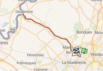
Trail Walking of 30 km to be discovered at Hauts-de-France, Nord, Marcq-en-Barœul. This trail is proposed by dautriche.
Description
Le long de la Deûle, un aller-retour sur chaque rive depuis le club RCM à la Frontière Belge, au confluent de la Deûle et de la Lys, au lieu-dit "Le Bout du Monde"
Positioning
Country:
France
Region :
Hauts-de-France
Department/Province :
Nord
Municipality :
Marcq-en-Barœul
Location:
Unknown
Start:(Dec)
Start:(UTM)
505851 ; 5612551 (31U) N.
Comments
Trails nearby
![Trail Walking Lille - Autour de la citadelle - Photo](https://media.geolcdn.com/t/375/260/ext.jpg?maxdim=2&url=https%3A%2F%2Fservices.sitytrail.com%2FGeolivesWS%2FDownloadMedia.ashx%3FTrailID%3D202857%26Media%3Dcd62111c-4a73-449f-8a35-c1f82fa269d1.jpg)
![Walking Walking](https://static1.geolcdn.com/sitytour/trail-icons/101.png)
Autour de la citadelle
Walking
Very easy
(2)
Lille,
Hauts-de-France,
Nord,
France
![](/images/other/stat-length.png)
5.5 km | 6.1 km-effort
Unknown
![](https://static1.geolcdn.com/siteimages/upload/files/16400158638029165_repeat_loop_refresh_sync_direction_icon.png)
Yes
![Trail Mountain bike Villeneuve-d'Ascq - Le tour des lacs - Villeneuve d'Ascq. - Photo](https://media.geolcdn.com/t/375/260/ext.jpg?maxdim=2&url=https%3A%2F%2Fservices.sitytrail.com%2FGeolivesWS%2FDownloadMedia.ashx%3FTrailID%3D112626%26Media%3D11224_6.jpg)
![Mountain bike Mountain bike](https://static1.geolcdn.com/sitytour/trail-icons/202.png)
Le tour des lacs - Villeneuve d'Ascq.
Mountain bike
Easy
(1)
Villeneuve-d'Ascq,
Hauts-de-France,
Nord,
France
![](/images/other/stat-length.png)
16.1 km | 17.3 km-effort
1h 30min
![](https://static1.geolcdn.com/siteimages/upload/files/16400158638029165_repeat_loop_refresh_sync_direction_icon.png)
Yes
![Trail Cycle Wambrechies - La Deule canalisée - Wambrechies - Photo](https://media.geolcdn.com/t/375/260/ext.jpg?maxdim=2&url=https%3A%2F%2Fservices.sitytrail.com%2FGeolivesWS%2FDownloadMedia.ashx%3FTrailID%3D111710%26Media%3D8020_6.jpg)
![Cycle Cycle](https://static1.geolcdn.com/sitytour/trail-icons/200.png)
La Deule canalisée - Wambrechies
Cycle
Medium
(2)
Wambrechies,
Hauts-de-France,
Nord,
France
![](/images/other/stat-length.png)
40 km | 43 km-effort
2h 30min
![](https://static1.geolcdn.com/siteimages/upload/files/16400158638029165_repeat_loop_refresh_sync_direction_icon.png)
Yes
![Trail Walking Lille - Autour de la citadelle de Lille - Photo](https://media.geolcdn.com/t/375/260/ext.jpg?maxdim=2&url=https%3A%2F%2Fservices.sitytrail.com%2FGeolivesWS%2FDownloadMedia.ashx%3FTrailID%3D109754%26Media%3D4580_6.jpg)
![Walking Walking](https://static1.geolcdn.com/sitytour/trail-icons/101.png)
Autour de la citadelle de Lille
Walking
Easy
(2)
Lille,
Hauts-de-France,
Nord,
France
![](/images/other/stat-length.png)
5.6 km | 6.3 km-effort
1h 30min
![](https://static1.geolcdn.com/siteimages/upload/files/16400158638029165_repeat_loop_refresh_sync_direction_icon.png)
Yes
![Trail Walking Wambrechies - Circuit du Genièvre - Wambrechies - Photo](https://media.geolcdn.com/t/375/260/ext.jpg?maxdim=2&url=https%3A%2F%2Fservices.sitytrail.com%2FGeolivesWS%2FDownloadMedia.ashx%3FTrailID%3D109008%26Media%3D2952_6.jpg)
![Walking Walking](https://static1.geolcdn.com/sitytour/trail-icons/101.png)
Circuit du Genièvre - Wambrechies
Walking
Medium
(2)
Wambrechies,
Hauts-de-France,
Nord,
France
![](/images/other/stat-length.png)
13.3 km | 14.2 km-effort
3h 15min
![](https://static1.geolcdn.com/siteimages/upload/files/16400158638029165_repeat_loop_refresh_sync_direction_icon.png)
Yes
![Walking Walking](https://static1.geolcdn.com/sitytour/trail-icons/101.png)
20230918 - TOTEMUS Lille - 5.4 Km
Walking
Easy
Lille,
Hauts-de-France,
Nord,
France
![](/images/other/stat-length.png)
5.4 km | 5.8 km-effort
1h 28min
![](https://static1.geolcdn.com/siteimages/upload/files/16400158638029165_repeat_loop_refresh_sync_direction_icon.png)
Yes
![Trail Walking Lille - LILLE (court) - de la gare L. Flandres au Minimes - Photo](https://media.geolcdn.com/t/375/260/ext.jpg?maxdim=2&url=https%3A%2F%2Fstatic1.geolcdn.com%2Fsiteimages%2Fupload%2Ffiles%2F1553511878bg_sport_marche.png)
![Walking Walking](https://static1.geolcdn.com/sitytour/trail-icons/101.png)
LILLE (court) - de la gare L. Flandres au Minimes
Walking
Easy
(1)
Lille,
Hauts-de-France,
Nord,
France
![](/images/other/stat-length.png)
4.1 km | 4.6 km-effort
1h 2min
![](https://static1.geolcdn.com/siteimages/upload/files/16400158638029165_repeat_loop_refresh_sync_direction_icon.png)
Yes
![Trail Mountain bike Lambersart - Deûle et ses campagnes - Photo](https://media.geolcdn.com/t/375/260/ext.jpg?maxdim=2&url=https%3A%2F%2Fstatic1.geolcdn.com%2Fsiteimages%2Fupload%2Ffiles%2F1524743154velo.jpg)
![Mountain bike Mountain bike](https://static1.geolcdn.com/sitytour/trail-icons/202.png)
Deûle et ses campagnes
Mountain bike
Easy
(2)
Lambersart,
Hauts-de-France,
Nord,
France
![](/images/other/stat-length.png)
24 km | 25 km-effort
1h 25min
![](https://static1.geolcdn.com/siteimages/upload/files/16400158638029165_repeat_loop_refresh_sync_direction_icon.png)
Yes
![Trail Walking Wambrechies - wambrechies quesnois - Photo](https://media.geolcdn.com/t/375/260/ext.jpg?maxdim=2&url=https%3A%2F%2Fstatic1.geolcdn.com%2Fsiteimages%2Fupload%2Ffiles%2F1553511878bg_sport_marche.png)
![Walking Walking](https://static1.geolcdn.com/sitytour/trail-icons/101.png)
wambrechies quesnois
Walking
Easy
(1)
Wambrechies,
Hauts-de-France,
Nord,
France
![](/images/other/stat-length.png)
10.7 km | 11.4 km-effort
2h 31min
![](https://static1.geolcdn.com/siteimages/upload/files/16400158638029165_repeat_loop_refresh_sync_direction_icon.png)
Yes