![](/images/other/stat-length.png)
![Trail Walking Tellin - TELLIN (Ri des Revaus). - Photo](https://media.geolcdn.com/t/1900/400/ext.pjpeg?maxdim=2&url=https%3A%2F%2Fservices.sitytrail.com%2FGeolivesWS%2FDownloadMedia.ashx%3FTrailID%3D1012920%26Media%3Dfix__20180729114130.jpg)
TELLIN (Ri des Revaus).
GerardBouche
User
![Length](/images/other/stat-length.png)
Length
10.5 km
![Max alt](https://static1.geolcdn.com/siteimages/upload/files/1508320355ic_sort_altitude_max_24dp.png)
Max alt
393 m
![Uphill gradient](https://static1.geolcdn.com/siteimages/upload/files/1508320355ic_sort_den_pos_24dp.png)
Uphill gradient
321 m
![Km-Effort](/images/other/stat-length.png)
Km-Effort
14.8 km
![Min alt](https://static1.geolcdn.com/siteimages/upload/files/1508320355ic_sort_altitude_min_24dp.png)
Min alt
232 m
![Downhill gradient](https://static1.geolcdn.com/siteimages/upload/files/1508320355ic_sort_den_neg_24dp.png)
Downhill gradient
322 m
![Boucle](https://static1.geolcdn.com/siteimages/upload/files/16400158638029165_repeat_loop_refresh_sync_direction_icon.png)
Boucle
Yes
Creation date :
2018-08-19 07:27:03.733
Updated on :
2018-08-19 07:27:03.733
![Walking](https://static1.geolcdn.com/sitytour/trail-icons/101.png)
3h06
Difficulty : Easy
![Scan this QR Code to open this trail in the SityTrail application](https://capi.geolives.com/qq0zvz2zws4bq2lad0pu/sitytour/trails/1012920/qr.png?size=200)
FREE GPS app for hiking
About
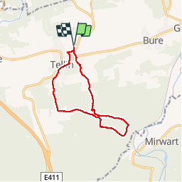
Trail Walking of 10.5 km to be discovered at Wallonia, Luxembourg, Tellin. This trail is proposed by GerardBouche.
Description
Très belle balade forestière ... une longue montée jusqu'à la "Croix Javalle" avant d'entrer par un petit sentier dans la forêt du Tiène des Potîs. Le retour par la Virée Rigaux, les Aloins et les anciennes Fonderies de Cloches.
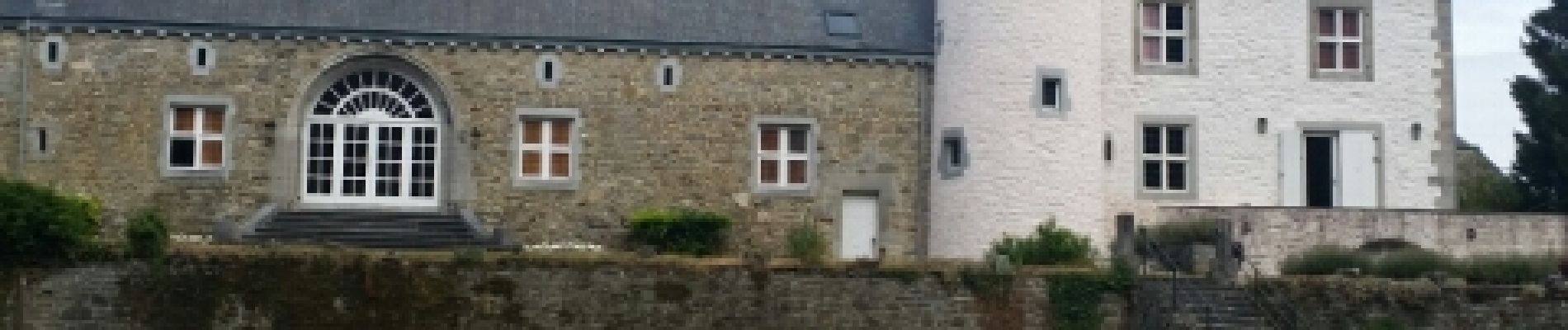
Positioning
Country:
Belgium
Region :
Wallonia
Department/Province :
Luxembourg
Municipality :
Tellin
Location:
Tellin
Start:(Dec)
Start:(UTM)
659019 ; 5550643 (31U) N.
Comments
Trails nearby
![Trail Walking Rochefort - Nature - The view from the Belvédère in Han-sur-Lesse - Photo](https://media.geolcdn.com/t/375/260/ext.jpg?maxdim=2&url=https%3A%2F%2Fservices.sitytrail.com%2FGeolivesWS%2FDownloadMedia.ashx%3FTrailID%3D193579%26Media%3D5797bc56-5327-4c2b-b581-d88d672bf775.jpg)
![Walking Walking](https://static1.geolcdn.com/sitytour/trail-icons/101.png)
Nature - The view from the Belvédère in Han-sur-Lesse
Walking
Difficult
(16)
Rochefort,
Wallonia,
Namur,
Belgium
![](/images/other/stat-length.png)
4.8 km | 6.3 km-effort
1h 20min
![](https://static1.geolcdn.com/siteimages/upload/files/16400158638029165_repeat_loop_refresh_sync_direction_icon.png)
Yes
![Trail Walking Tellin - Tellin. Natura 2000, des sites qui valent le détour ! Lx 7 - Photo](https://media.geolcdn.com/t/375/260/ext.jpg?maxdim=2&url=https%3A%2F%2Fservices.sitytrail.com%2FGeolivesWS%2FDownloadMedia.ashx%3FTrailID%3D139723%26Media%3D4b6cd866-c01c-4092-b3ae-893d48db31d3.JPG)
![Walking Walking](https://static1.geolcdn.com/sitytour/trail-icons/101.png)
Tellin. Natura 2000, des sites qui valent le détour ! Lx 7
Walking
Medium
(7)
Tellin,
Wallonia,
Luxembourg,
Belgium
![](/images/other/stat-length.png)
9.6 km | 11.9 km-effort
1h 30min
![](https://static1.geolcdn.com/siteimages/upload/files/16400158638029165_repeat_loop_refresh_sync_direction_icon.png)
Yes
![Trail Walking Rochefort - RB-Na-07 Raccourci - Ronde au pays des grottes - Photo](https://media.geolcdn.com/t/375/260/ext.jpg?maxdim=2&url=https%3A%2F%2Fservices.sitytrail.com%2FGeolivesWS%2FDownloadMedia.ashx%3FTrailID%3D213757%26Media%3D27dc9085-0323-4669-9df4-56be0512bfe6.jpg)
![Walking Walking](https://static1.geolcdn.com/sitytour/trail-icons/101.png)
RB-Na-07 Raccourci - Ronde au pays des grottes
Walking
Easy
(9)
Rochefort,
Wallonia,
Namur,
Belgium
![](/images/other/stat-length.png)
18.4 km | 24 km-effort
4h 59min
![](https://static1.geolcdn.com/siteimages/upload/files/16400158638029165_repeat_loop_refresh_sync_direction_icon.png)
Yes
![Trail Walking Saint-Hubert - Mirwart_Vieux Moulin de Mirwart_Alternative Forêt (SH29 bis) - Photo](https://media.geolcdn.com/t/375/260/ext.jpg?maxdim=2&url=https%3A%2F%2Fservices.sitytrail.com%2FGeolivesWS%2FDownloadMedia.ashx%3FTrailID%3D366988%26Media%3D029a75cb-b10f-4900-87ea-e92327ef26cb.jpg)
![Walking Walking](https://static1.geolcdn.com/sitytour/trail-icons/101.png)
Mirwart_Vieux Moulin de Mirwart_Alternative Forêt (SH29 bis)
Walking
Difficult
(12)
Saint-Hubert,
Wallonia,
Luxembourg,
Belgium
![](/images/other/stat-length.png)
10.8 km | 14.2 km-effort
3h 4min
![](https://static1.geolcdn.com/siteimages/upload/files/16400158638029165_repeat_loop_refresh_sync_direction_icon.png)
Yes
![Trail Walking Rochefort - Nature : Belvaux -Les Rouges-Gorges (the robins) - Photo](https://media.geolcdn.com/t/375/260/ext.jpg?maxdim=2&url=https%3A%2F%2Fservices.sitytrail.com%2FGeolivesWS%2FDownloadMedia.ashx%3FTrailID%3D262701%26Media%3D8d8e8ae8-731b-4f5d-ad26-e3a028302c41.jpg)
![Walking Walking](https://static1.geolcdn.com/sitytour/trail-icons/101.png)
Nature : Belvaux -Les Rouges-Gorges (the robins)
Walking
Easy
(8)
Rochefort,
Wallonia,
Namur,
Belgium
![](/images/other/stat-length.png)
6.5 km | 8.4 km-effort
1h 20min
![](https://static1.geolcdn.com/siteimages/upload/files/16400158638029165_repeat_loop_refresh_sync_direction_icon.png)
Yes
![Trail Walking Rochefort - Nature : Belvaux -Les Rouges-Gorges (the robins) - Photo](https://media.geolcdn.com/t/375/260/ext.jpg?maxdim=2&url=https%3A%2F%2Fservices.sitytrail.com%2FGeolivesWS%2FDownloadMedia.ashx%3FTrailID%3D183910%26Media%3D410abbc6-7c13-4109-b7d7-92f0aeb383e2.jpg)
![Walking Walking](https://static1.geolcdn.com/sitytour/trail-icons/101.png)
Nature : Belvaux -Les Rouges-Gorges (the robins)
Walking
Easy
(13)
Rochefort,
Wallonia,
Namur,
Belgium
![](/images/other/stat-length.png)
5.8 km | 7.6 km-effort
1h 20min
![](https://static1.geolcdn.com/siteimages/upload/files/16400158638029165_repeat_loop_refresh_sync_direction_icon.png)
Yes
![Trail Walking Rochefort - Nature - A discovery trail through Han-sur-Lesse - Photo](https://media.geolcdn.com/t/375/260/ext.jpg?maxdim=2&url=https%3A%2F%2Fservices.sitytrail.com%2FGeolivesWS%2FDownloadMedia.ashx%3FTrailID%3D148989%26Media%3D3c202c2f-ee01-4903-bd25-24913ec8637b.jpg)
![Walking Walking](https://static1.geolcdn.com/sitytour/trail-icons/101.png)
Nature - A discovery trail through Han-sur-Lesse
Walking
Very easy
(15)
Rochefort,
Wallonia,
Namur,
Belgium
![](/images/other/stat-length.png)
4.8 km | 5.8 km-effort
1h 15min
![](https://static1.geolcdn.com/siteimages/upload/files/16400158638029165_repeat_loop_refresh_sync_direction_icon.png)
Yes
![Trail Walking Tellin - GG-Lu-13_Grupont - Poix-Saint-Hubert - Photo](https://media.geolcdn.com/t/375/260/5959367f-35e5-42da-bbcc-7bf6a947c3d1.jpg&format=jpg&maxdim=2)
![Walking Walking](https://static1.geolcdn.com/sitytour/trail-icons/101.png)
GG-Lu-13_Grupont - Poix-Saint-Hubert
Walking
Very difficult
(3)
Tellin,
Wallonia,
Luxembourg,
Belgium
![](/images/other/stat-length.png)
26 km | 34 km-effort
7h 23min
![](https://static1.geolcdn.com/siteimages/upload/files/16400158638029165_repeat_loop_refresh_sync_direction_icon.png)
No
![Trail Walking Tellin - Balade à Grupont - Photo](https://media.geolcdn.com/t/375/260/ext.jpg?maxdim=2&url=https%3A%2F%2Fservices.sitytrail.com%2FGeolivesWS%2FDownloadMedia.ashx%3FTrailID%3D963883%26Media%3D35fabe2c-0877-4435-b4f9-1ab0863175f9.jpg)
![Walking Walking](https://static1.geolcdn.com/sitytour/trail-icons/101.png)
Balade à Grupont
Walking
Easy
(1)
Tellin,
Wallonia,
Luxembourg,
Belgium
![](/images/other/stat-length.png)
8.4 km | 11.9 km-effort
2h 33min
![](https://static1.geolcdn.com/siteimages/upload/files/16400158638029165_repeat_loop_refresh_sync_direction_icon.png)
Yes