![](/images/other/stat-length.png)
![Trail Mountain bike Cubières - GTMC de Claire - 7 - Photo](https://media.geolcdn.com/t/1900/400/ext.pjpeg?maxdim=2&url=https%3A%2F%2Fservices.sitytrail.com%2FGeolivesWS%2FDownloadMedia.ashx%3FTrailID%3D101273%26Media%3D760_1.jpg)
GTMC de Claire - 7
tracegps
User
![Length](/images/other/stat-length.png)
Length
75 km
![Max alt](https://static1.geolcdn.com/siteimages/upload/files/1508320355ic_sort_altitude_max_24dp.png)
Max alt
1547 m
![Uphill gradient](https://static1.geolcdn.com/siteimages/upload/files/1508320355ic_sort_den_pos_24dp.png)
Uphill gradient
1258 m
![Km-Effort](/images/other/stat-length.png)
Km-Effort
95 km
![Min alt](https://static1.geolcdn.com/siteimages/upload/files/1508320355ic_sort_altitude_min_24dp.png)
Min alt
470 m
![Downhill gradient](https://static1.geolcdn.com/siteimages/upload/files/1508320355ic_sort_den_neg_24dp.png)
Downhill gradient
2241 m
![Boucle](https://static1.geolcdn.com/siteimages/upload/files/16400158638029165_repeat_loop_refresh_sync_direction_icon.png)
Boucle
No
Creation date :
2014-12-10 00:00:00.0
Updated on :
2014-12-10 00:00:00.0
![Mountain bike](https://static1.geolcdn.com/sitytour/trail-icons/202.png)
5h00
Difficulty : Very difficult
![Scan this QR Code to open this trail in the SityTrail application](https://capi.geolives.com/qq0zvz2zws4bq2lad0pu/sitytour/trails/101273/qr.png?size=200)
FREE GPS app for hiking
About
Trail Mountain bike of 75 km to be discovered at Occitania, Lozère, Cubières. This trail is proposed by tracegps.
Description
La Grande Traversée du Massif Central par Claire et ses amis. En douze étapes, revivez cette aventure sur son site. Septième étape: mardi 08 Août 2006. Retrouvez le résumé de la journée, les conseils et les photos ICI
Positioning
Country:
France
Region :
Occitania
Department/Province :
Lozère
Municipality :
Cubières
Location:
Unknown
Start:(Dec)
Start:(UTM)
559584 ; 4921551 (31T) N.
Comments
Trails nearby
![Trail Mountain bike Cubières - TOUR MONT LOZERE - Photo](https://media.geolcdn.com/t/375/260/a1bfdb58-8337-4d84-b53e-6cb2f940b716.jpeg&format=jpg&maxdim=2)
![Mountain bike Mountain bike](https://static1.geolcdn.com/sitytour/trail-icons/202.png)
TOUR MONT LOZERE
Mountain bike
Very difficult
(1)
Cubières,
Occitania,
Lozère,
France
![](/images/other/stat-length.png)
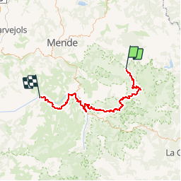
38 km | 47 km-effort
3h 14min
![](https://static1.geolcdn.com/siteimages/upload/files/16400158638029165_repeat_loop_refresh_sync_direction_icon.png)
Yes
![Walking Walking](https://static1.geolcdn.com/sitytour/trail-icons/101.png)
Les prairies du col de Finiels et des monts Lozere
Walking
Medium
(1)
Mont Lozère et Goulet,
Occitania,
Lozère,
France
![](/images/other/stat-length.png)
7.2 km | 9.5 km-effort
2h 59min
![](https://static1.geolcdn.com/siteimages/upload/files/16400158638029165_repeat_loop_refresh_sync_direction_icon.png)
Yes
![Trail Walking Mont Lozère et Goulet - Bleymar _ Le Pont Montvert - Photo](https://media.geolcdn.com/t/375/260/ext.jpg?maxdim=2&url=https%3A%2F%2Fservices.sitytrail.com%2FGeolivesWS%2FDownloadMedia.ashx%3FTrailID%3D463465%26Media%3Dfix__20150819092348.jpg)
![Walking Walking](https://static1.geolcdn.com/sitytour/trail-icons/101.png)
Bleymar _ Le Pont Montvert
Walking
Difficult
(1)
Mont Lozère et Goulet,
Occitania,
Lozère,
France
![](/images/other/stat-length.png)
22 km | 32 km-effort
5h 19min
![](https://static1.geolcdn.com/siteimages/upload/files/16400158638029165_repeat_loop_refresh_sync_direction_icon.png)
No
![Trail Walking Mont Lozère et Goulet - Chemin de Stevenson - Le Bleymard vers Le Pont de Montvert - Photo](https://media.geolcdn.com/t/375/260/ext.jpg?maxdim=2&url=https%3A%2F%2Fservices.sitytrail.com%2FGeolivesWS%2FDownloadMedia.ashx%3FTrailID%3D109272%26Media%3D3392_1.jpg)
![Walking Walking](https://static1.geolcdn.com/sitytour/trail-icons/101.png)
Chemin de Stevenson - Le Bleymard vers Le Pont de Montvert
Walking
Difficult
(1)
Mont Lozère et Goulet,
Occitania,
Lozère,
France
![](/images/other/stat-length.png)
18.9 km | 28 km-effort
4h 30min
![](https://static1.geolcdn.com/siteimages/upload/files/16400158638029165_repeat_loop_refresh_sync_direction_icon.png)
No
![Trail Walking Pont de Montvert - Sud Mont Lozère - Finiels/ sommet / station du Bleymard en boucle - Photo](https://media.geolcdn.com/t/375/260/f8048304-3a05-4fd0-a0e7-03457722fcee.jpg&format=jpg&maxdim=2)
![Walking Walking](https://static1.geolcdn.com/sitytour/trail-icons/101.png)
Finiels/ sommet / station du Bleymard en boucle
Walking
Difficult
Pont de Montvert - Sud Mont Lozère,
Occitania,
Lozère,
France
![](/images/other/stat-length.png)
20 km | 30 km-effort
5h 38min
![](https://static1.geolcdn.com/siteimages/upload/files/16400158638029165_repeat_loop_refresh_sync_direction_icon.png)
Yes
![Trail Walking Mont Lozère et Goulet - Stevenson étape 8 - Photo](https://media.geolcdn.com/t/375/260/b34e09af-9026-4127-8636-d1e451b59807.jpg&format=jpg&maxdim=2)
![Walking Walking](https://static1.geolcdn.com/sitytour/trail-icons/101.png)
Stevenson étape 8
Walking
Difficult
Mont Lozère et Goulet,
Occitania,
Lozère,
France
![](/images/other/stat-length.png)
20 km | 30 km-effort
5h 29min
![](https://static1.geolcdn.com/siteimages/upload/files/16400158638029165_repeat_loop_refresh_sync_direction_icon.png)
No
![Trail Walking Mont Lozère et Goulet - sources du tarn - Photo](https://media.geolcdn.com/t/375/260/ext.jpg?maxdim=2&url=https%3A%2F%2Fstatic1.geolcdn.com%2Fsiteimages%2Fupload%2Ffiles%2F1553511878bg_sport_marche.png)
![Walking Walking](https://static1.geolcdn.com/sitytour/trail-icons/101.png)
sources du tarn
Walking
Medium
(1)
Mont Lozère et Goulet,
Occitania,
Lozère,
France
![](/images/other/stat-length.png)
13.3 km | 17.3 km-effort
3h 50min
![](https://static1.geolcdn.com/siteimages/upload/files/16400158638029165_repeat_loop_refresh_sync_direction_icon.png)
No
![Trail Electric bike Cubières - ETANG DE BARANDON PAR LA STATION DE SKI - Photo](https://media.geolcdn.com/t/375/260/02cfb49c-be69-4aa6-8d1f-cab2e83a60e7.jpeg&format=jpg&maxdim=2)
![Electric bike Electric bike](https://static1.geolcdn.com/sitytour/trail-icons/205.png)
ETANG DE BARANDON PAR LA STATION DE SKI
Electric bike
Medium
Cubières,
Occitania,
Lozère,
France
![](/images/other/stat-length.png)
31 km | 36 km-effort
2h 11min
![](https://static1.geolcdn.com/siteimages/upload/files/16400158638029165_repeat_loop_refresh_sync_direction_icon.png)
Yes
![Trail Walking Mont Lozère et Goulet - Pont de Montvert - Photo](https://media.geolcdn.com/t/375/260/ef737a4f-a7c1-4642-affe-b45fe92c561f.jpg&format=jpg&maxdim=2)
![Walking Walking](https://static1.geolcdn.com/sitytour/trail-icons/101.png)
Pont de Montvert
Walking
Very difficult
Mont Lozère et Goulet,
Occitania,
Lozère,
France
![](/images/other/stat-length.png)
19.4 km | 29 km-effort
6h 52min
![](https://static1.geolcdn.com/siteimages/upload/files/16400158638029165_repeat_loop_refresh_sync_direction_icon.png)
No