Trail Mountain bike Vézins-de-Lévézou - Tour des Monts du Lévézou - Photo

Tour des Monts du Lévézou

 tracegps
tracegps

User

© OpenStreetMap contributors
Length
Length
92 km
Max alt
Max alt
1153 m
Uphill gradient
Uphill gradient
2113 m
Km-Effort
Km-Effort  
120 km
Min alt
Min alt
740 m
Downhill gradient
Downhill gradient
2121 m
Boucle
Boucle
Yes
Creation date :
2014-12-10 00:00:00.0
Updated on :
2014-12-10 00:00:00.0

(2 Reviews)

Mountain bike
Mountain bike
11h00
Difficulty : Very difficult

Scan this QR Code to open this trail in the SityTrail application

FREE GPS app for hiking

Logo SityTrail SityTrail

IGN / Geographical institutes

Download SityTrail from the App Store Download SityTrail from Google Play

Logo SityTrail SityTrail World

The world is yours!

Download SityTrail from the App Store Download SityTrail from Google Play Download SityTrail on Huawei AppGallery

About

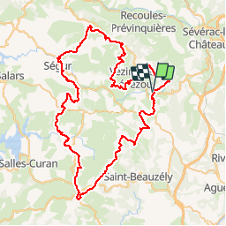
Trail Mountain bike of 92 km to be discovered at Occitania, Aveyron, Vézins-de-Lévézou. This trail is proposed by tracegps.

Description

Un parcours fabuleux : l'austérité du Pal, l'étonnante lande du Ram, la panoramique crête de Vaysse Rodier, les bois de la chapelle de Bergounhoux, les grands espaces de Curan, les horizons sans fins de la crête de bouloc, la visions globale à 360° du mont Seigne, la haute vallée de la muse (je ne peux pas la qualifier car nous l'avons faites sous la pluie) et le fond de la vallée de la Lumensonesque et son ambiance de calcaire. On devrait en entendre parler à l'avenir si l'Aveyron rédige un topo.. ATTENTION, CIRCUIT TRONQUÉ - de Saint Laurent à La Clau, un orage ne nous a pas permis de terminer la boucle par La Glène

Elevation profile

Photos

Positioning

Country:
France
Region :
Occitania
Department/Province :
Aveyron
Municipality :
Vézins-de-Lévézou
Location:
Unknown
Start:(UTM)
498635 ; 4901034 (31T) N.

Comments

Please log in to post a review or rate the element


Trails nearby

Trail Walking Vézins-de-Lévézou - Pic du Pal  - Plateau du Lévézou - Gleyzenove - Photo
Walking
tracegps

Walking

Difficult
Vézins-de-Lévézou, Occitania, Aveyron, France
22 km | 30 km-effort
6h 0min
Yes
Trail Walking Vézins-de-Lévézou - Autour de VEZINS PIC DU PAL La Clau VEZINS - Photo
Walking
Dominique48

Walking

Medium
Vézins-de-Lévézou, Occitania, Aveyron, France
14.6 km | 19.9 km-effort
4h 25min
Yes
Trail Other activity Vézins-de-Lévézou - gleyzeunove - Photo
Other activity
Mas12

Other activity

Difficult
Vézins-de-Lévézou, Occitania, Aveyron, France
20 km | 27 km-effort
3h 26min
Yes
Trail Walking Vézins-de-Lévézou - la clau - Photo
Walking
leglisemichel

Walking

Medium
Vézins-de-Lévézou, Occitania, Aveyron, France
8 km | 11 km-effort
1h 58min
Yes
Trail Walking Vézins-de-Lévézou - vezins le pal-viaur - Photo
Walking
Frayssinet

Walking

Medium
Vézins-de-Lévézou, Occitania, Aveyron, France
21 km | 0 m-effort
5h 35min
Yes
Trail Walking Vézins-de-Lévézou - lesserac  - Photo
Walking
dusty3466

Walking

Medium
Vézins-de-Lévézou, Occitania, Aveyron, France
6.9 km | 8.7 km-effort
2h 9min
Yes
Trail Walking Sévérac d'Aveyron - ivan - Photo
Walking
ivansorro

Walking

Very easy
Sévérac d'Aveyron, Occitania, Aveyron, France
3.9 km | 4.8 km-effort
1h 35min
No
Trail On foot Vézins-de-Lévézou - Puech du Pal - Photo
On foot
ZITO12

On foot

Easy
Vézins-de-Lévézou, Occitania, Aveyron, France
15.7 km | 21 km-effort
Unknown
Yes
Trail Walking Vézins-de-Lévézou - Le Clau-Vézins - Photo
Walking
catherineslater

Walking

Very easy
Vézins-de-Lévézou, Occitania, Aveyron, France
3 km | 4.5 km-effort
57min
No


Close
My subscriptions