![](/images/other/stat-length.png)
![Trail Walking Wangenbourg-Engenthal - Circuit de la Mossig - Photo](https://media.geolcdn.com/t/1900/400/ext.pjpeg?maxdim=2&url=https%3A%2F%2Fservices.sitytrail.com%2FGeolivesWS%2FDownloadMedia.ashx%3FTrailID%3D101111%26Media%3D603_1.jpg)
Circuit de la Mossig
tracegps
User
![Length](/images/other/stat-length.png)
Length
19.7 km
![Max alt](https://static1.geolcdn.com/siteimages/upload/files/1508320355ic_sort_altitude_max_24dp.png)
Max alt
481 m
![Uphill gradient](https://static1.geolcdn.com/siteimages/upload/files/1508320355ic_sort_den_pos_24dp.png)
Uphill gradient
499 m
![Km-Effort](/images/other/stat-length.png)
Km-Effort
26 km
![Min alt](https://static1.geolcdn.com/siteimages/upload/files/1508320355ic_sort_altitude_min_24dp.png)
Min alt
293 m
![Downhill gradient](https://static1.geolcdn.com/siteimages/upload/files/1508320355ic_sort_den_neg_24dp.png)
Downhill gradient
499 m
![Boucle](https://static1.geolcdn.com/siteimages/upload/files/16400158638029165_repeat_loop_refresh_sync_direction_icon.png)
Boucle
Yes
Creation date :
2014-12-10 00:00:00.0
Updated on :
2014-12-10 00:00:00.0
![Walking](https://static1.geolcdn.com/sitytour/trail-icons/101.png)
4h00
Difficulty : Difficult
![Scan this QR Code to open this trail in the SityTrail application](https://capi.geolives.com/qq0zvz2zws4bq2lad0pu/sitytour/trails/101111/qr.png?size=200)
FREE GPS app for hiking
About
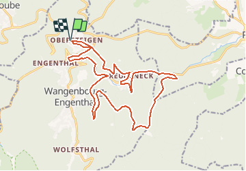
Trail Walking of 19.7 km to be discovered at Grand Est, Bas-Rhin, Wangenbourg-Engenthal. This trail is proposed by tracegps.
Description
Ce circuit démarre par de la descente au départ d'Obersteigen.Les chemins sont larges, stabilisés ( sauf lors de la première montée ) et dégagés de tout arbre. Aucune difficultés particulières à signaler. Le balisage est en bon état. A voir ICI
Positioning
Country:
France
Region :
Grand Est
Department/Province :
Bas-Rhin
Municipality :
Wangenbourg-Engenthal
Location:
Unknown
Start:(Dec)
Start:(UTM)
375219 ; 5388990 (32U) N.
Comments
Trails nearby
![Trail Walking Reinhardsmunster - 2021-09-01 Marche Reinhardsmunster Haut Barr - Photo](https://media.geolcdn.com/t/375/260/ext.jpg?maxdim=2&url=https%3A%2F%2Fmedia.geolcdn.com%2Ff%2F266b2ac9-dd10-4dc7-a762-c9d36720cc88.jpg)
![Walking Walking](https://static1.geolcdn.com/sitytour/trail-icons/101.png)
2021-09-01 Marche Reinhardsmunster Haut Barr
Walking
Very difficult
Reinhardsmunster,
Grand Est,
Bas-Rhin,
France
![](/images/other/stat-length.png)
21 km | 32 km-effort
6h 39min
![](https://static1.geolcdn.com/siteimages/upload/files/16400158638029165_repeat_loop_refresh_sync_direction_icon.png)
Yes
![Trail Walking Reinhardsmunster - 2020-06-13 Marche Ditschelkopf Schweizerberg - Photo](https://media.geolcdn.com/t/375/260/ext.jpg?maxdim=2&url=https%3A%2F%2Fmedia.geolcdn.com%2Ff%2Fd6670ae9-2bf3-459d-a4b8-1c117627d287.jpg)
![Walking Walking](https://static1.geolcdn.com/sitytour/trail-icons/101.png)
2020-06-13 Marche Ditschelkopf Schweizerberg
Walking
Very easy
Reinhardsmunster,
Grand Est,
Bas-Rhin,
France
![](/images/other/stat-length.png)
14.5 km | 22 km-effort
4h 52min
![](https://static1.geolcdn.com/siteimages/upload/files/16400158638029165_repeat_loop_refresh_sync_direction_icon.png)
Yes
![Trail Walking Wangenbourg-Engenthal - 2020-03-14 Marche Engenthal le bas - Photo](https://media.geolcdn.com/t/375/260/ext.jpg?maxdim=2&url=https%3A%2F%2Fmedia.geolcdn.com%2Ff%2Fba70735c-7023-4458-a456-f43a6f2e7606.jpg)
![Walking Walking](https://static1.geolcdn.com/sitytour/trail-icons/101.png)
2020-03-14 Marche Engenthal le bas
Walking
Very easy
Wangenbourg-Engenthal,
Grand Est,
Bas-Rhin,
France
![](/images/other/stat-length.png)
14.3 km | 22 km-effort
4h 27min
![](https://static1.geolcdn.com/siteimages/upload/files/16400158638029165_repeat_loop_refresh_sync_direction_icon.png)
Yes
![Trail Walking Wangenbourg-Engenthal - 2019-11-16 Marche Wangenbourg Castelberg - Photo](https://media.geolcdn.com/t/375/260/ext.jpg?maxdim=2&url=https%3A%2F%2Fmedia.geolcdn.com%2Ff%2F5fe565fb-6e88-4bed-a889-a75a33bb061a.jpg)
![Walking Walking](https://static1.geolcdn.com/sitytour/trail-icons/101.png)
2019-11-16 Marche Wangenbourg Castelberg
Walking
Very easy
Wangenbourg-Engenthal,
Grand Est,
Bas-Rhin,
France
![](/images/other/stat-length.png)
19.8 km | 31 km-effort
4h 51min
![](https://static1.geolcdn.com/siteimages/upload/files/16400158638029165_repeat_loop_refresh_sync_direction_icon.png)
Yes
![Trail Walking Wangenbourg-Engenthal - 2017-02-24 Marche Schneeberg - Photo](https://media.geolcdn.com/t/375/260/ext.jpg?maxdim=2&url=https%3A%2F%2Fstatic1.geolcdn.com%2Fsiteimages%2Fupload%2Ffiles%2F1553511878bg_sport_marche.png)
![Walking Walking](https://static1.geolcdn.com/sitytour/trail-icons/101.png)
2017-02-24 Marche Schneeberg
Walking
Very easy
(1)
Wangenbourg-Engenthal,
Grand Est,
Bas-Rhin,
France
![](/images/other/stat-length.png)
12.8 km | 19.9 km-effort
Unknown
![](https://static1.geolcdn.com/siteimages/upload/files/16400158638029165_repeat_loop_refresh_sync_direction_icon.png)
Yes
![Trail Walking Wangenbourg-Engenthal - ARCA WANGENBOURG - Photo](https://media.geolcdn.com/t/375/260/ext.jpg?maxdim=2&url=https%3A%2F%2Fmedia.geolcdn.com%2Ff%2F8387777e-0af4-46e8-976a-a6425ad883f8.jpg)
![Walking Walking](https://static1.geolcdn.com/sitytour/trail-icons/101.png)
ARCA WANGENBOURG
Walking
Medium
Wangenbourg-Engenthal,
Grand Est,
Bas-Rhin,
France
![](/images/other/stat-length.png)
13.2 km | 19 km-effort
4h 19min
![](https://static1.geolcdn.com/siteimages/upload/files/16400158638029165_repeat_loop_refresh_sync_direction_icon.png)
Yes
![Trail Walking Dabo - Windsbourg Dabo - Photo](https://media.geolcdn.com/t/375/260/ext.jpg?maxdim=2&url=https%3A%2F%2Fmedia.geolcdn.com%2Ff%2F849eb1af-57e5-4b6a-92a2-d1e4a3c0d38f.jpg)
![Walking Walking](https://static1.geolcdn.com/sitytour/trail-icons/101.png)
![Trail Walking Wangenbourg-Engenthal - 2023-04-28_17h34m45_2023-04-26_10-35(2) - Photo](https://media.geolcdn.com/t/375/260/ext.jpg?maxdim=2&url=https%3A%2F%2Fmedia.geolcdn.com%2Ff%2Fee107caa-b5bb-4c13-b62b-5f4288972d90.jpg)
![Walking Walking](https://static1.geolcdn.com/sitytour/trail-icons/101.png)
2023-04-28_17h34m45_2023-04-26_10-35(2)
Walking
Medium
Wangenbourg-Engenthal,
Grand Est,
Bas-Rhin,
France
![](/images/other/stat-length.png)
14.1 km | 22 km-effort
4h 56min
![](https://static1.geolcdn.com/siteimages/upload/files/16400158638029165_repeat_loop_refresh_sync_direction_icon.png)
Yes
![Trail Walking Dabo - 2022-11-01 Marche Dabo et ses Rochers - Photo](https://media.geolcdn.com/t/375/260/ext.jpg?maxdim=2&url=https%3A%2F%2Fmedia.geolcdn.com%2Ff%2F63c4e37b-f9cd-403d-a535-8b98d78038cb.jpg)
![Walking Walking](https://static1.geolcdn.com/sitytour/trail-icons/101.png)
2022-11-01 Marche Dabo et ses Rochers
Walking
Very difficult
Dabo,
Grand Est,
Moselle,
France
![](/images/other/stat-length.png)
26 km | 38 km-effort
7h 8min
![](https://static1.geolcdn.com/siteimages/upload/files/16400158638029165_repeat_loop_refresh_sync_direction_icon.png)
Yes