Trail Mountain bike La Plagne-Tarentaise - le Mont de la Guerre, le col du Jovet - Photo

le Mont de la Guerre, le col du Jovet

 tracegps
tracegps

User

© OpenStreetMap contributors
Length
Length
33 km
Max alt
Max alt
2438 m
Uphill gradient
Uphill gradient
1574 m
Km-Effort
Km-Effort  
54 km
Min alt
Min alt
1550 m
Downhill gradient
Downhill gradient
1571 m
Boucle
Boucle
Yes
Creation date :
2014-12-10 00:00:00.0
Updated on :
2014-12-10 00:00:00.0

(0 Reviews)

Mountain bike
Mountain bike
3h15
Difficulty : Very difficult

Scan this QR Code to open this trail in the SityTrail application

FREE GPS app for hiking

Logo SityTrail SityTrail

IGN / Geographical institutes

Download SityTrail from the App Store Download SityTrail from Google Play

Logo SityTrail SityTrail World

The world is yours!

Download SityTrail from the App Store Download SityTrail from Google Play Download SityTrail on Huawei AppGallery

About

Trail Mountain bike of 33 km to be discovered at Auvergne-Rhône-Alpes, Savoy, La Plagne-Tarentaise. This trail is proposed by tracegps.

Description

28 Juillet 2005 Encore une belle journée, cette fois ci nous partons avec le pique nique pour la journée sur un parcours comportant une côte de près de 1000m de dénivelé, il faut s'entraîner pour Val Thorens ! La suite est ICI

Elevation profile

Photos

Positioning

Country:
France
Region :
Auvergne-Rhône-Alpes
Department/Province :
Savoy
Municipality :
La Plagne-Tarentaise
Location:
Mâcot-la-Plagne
Start:(Dec)
Start:(UTM)
318688 ; 5041795 (32T) N.

Trails nearby

Trail On foot Aime-la-Plagne - Le Mont Jovet - Photo
On foot
GUIDE+

On foot

Medium
Aime-la-Plagne, Auvergne-Rhône-Alpes, Savoy, France
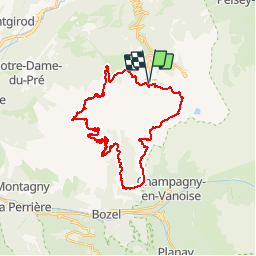
11.1 km | 21 km-effort
4h 45min
Yes
Trail On foot La Plagne-Tarentaise - Les Frasses - Photo
On foot
GUIDE+

On foot

Easy
La Plagne-Tarentaise, Auvergne-Rhône-Alpes, Savoy, France
5.7 km | 7.8 km-effort
1h 45min
No
Trail On foot La Plagne-Tarentaise - Boucle du Carroley - Photo
On foot
GUIDE+

On foot

Easy
La Plagne-Tarentaise, Auvergne-Rhône-Alpes, Savoy, France
4.2 km | 7.5 km-effort
1h 41min
No
Trail On foot La Plagne-Tarentaise - Sentier Découverte Grande Rochette - Photo
On foot
GUIDE+

On foot

Easy
La Plagne-Tarentaise, Auvergne-Rhône-Alpes, Savoy, France
9.2 km | 16.3 km-effort
3h 42min
Yes
Trail On foot La Plagne-Tarentaise - Boucle de Roche de Mio - Photo
On foot
GUIDE+

On foot

Easy
La Plagne-Tarentaise, Auvergne-Rhône-Alpes, Savoy, France
5.6 km | 12.1 km-effort
2h 44min
No
Trail On foot Aime-la-Plagne - Route Balcon - Photo
On foot
GUIDE+

On foot

Easy
Aime-la-Plagne, Auvergne-Rhône-Alpes, Savoy, France
7.4 km | 9.6 km-effort
2h 11min
No
Trail On foot La Plagne-Tarentaise - Le Lac Vert - Photo
On foot
GUIDE+

On foot

Easy
La Plagne-Tarentaise, Auvergne-Rhône-Alpes, Savoy, France
4.6 km | 7 km-effort
1h 36min
Yes
Trail Walking Bozel - Le Mont Jovet - Bozel - Photo
Walking
tracegps

Walking

Difficult
(1)
Bozel, Auvergne-Rhône-Alpes, Savoy, France
17.3 km | 32 km-effort
4h 45min
Yes
Trail Walking La Plagne-Tarentaise - Plagne Soleil, La Grande Rochette, Plagne Centre  - Photo
Walking
GUIDE
lhomme.ph

Walking

Difficult
La Plagne-Tarentaise, Auvergne-Rhône-Alpes, Savoy, France
8.6 km | 14.5 km-effort
2h 57min
No


Close
My subscriptions