![](/images/other/stat-length.png)
![Trail Mountain bike Wisches - Rando Vallée de la Bruche - Photo](https://media.geolcdn.com/t/1900/400/ext.pjpeg?maxdim=2&url=https%3A%2F%2Fservices.sitytrail.com%2FGeolivesWS%2FDownloadMedia.ashx%3FTrailID%3D101061%26Media%3D552_1.jpg)
Rando Vallée de la Bruche
tracegps
User
![Length](/images/other/stat-length.png)
![Max alt](https://static1.geolcdn.com/siteimages/upload/files/1508320355ic_sort_altitude_max_24dp.png)
![Uphill gradient](https://static1.geolcdn.com/siteimages/upload/files/1508320355ic_sort_den_pos_24dp.png)
![Km-Effort](/images/other/stat-length.png)
![Min alt](https://static1.geolcdn.com/siteimages/upload/files/1508320355ic_sort_altitude_min_24dp.png)
![Downhill gradient](https://static1.geolcdn.com/siteimages/upload/files/1508320355ic_sort_den_neg_24dp.png)
![Boucle](https://static1.geolcdn.com/siteimages/upload/files/16400158638029165_repeat_loop_refresh_sync_direction_icon.png)
![Mountain bike](https://static1.geolcdn.com/sitytour/trail-icons/202.png)
3h19
Difficulty : Very difficult
![Scan this QR Code to open this trail in the SityTrail application](https://capi.geolives.com/qq0zvz2zws4bq2lad0pu/sitytour/trails/101061/qr.png?size=200)
FREE GPS app for hiking
About
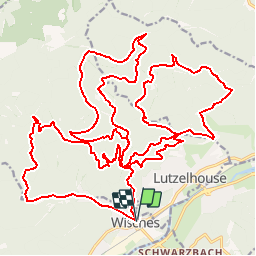
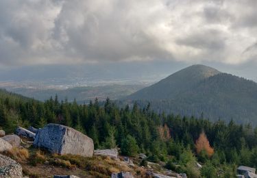
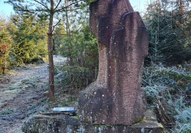
Trail Mountain bike of 38 km to be discovered at Grand Est, Bas-Rhin, Wisches. This trail is proposed by tracegps.
Description
Ce circuit a l'avantage d'être en trèfle. Le point central ( La Place des Musiciens ) en est matérialisée par une *. Cela vous permet d'additionner les tracés en fonction de votre forme du moment. La première partie vous permettant d'accéder à ce point ne présente pas de difficultés particulières.Une longue portion macadamée vous amène vers la M.F. du Petit Wisches et permet de s'échauffer.La boucle de droite est roulante.Ca descend d'abord pas mal avant de remonter.Les différentes montées sont facilement surmontables , certaines avec l'élan que vous aurez pris dans la descente précédente.La boucle du haut est un peu plus difficile..... La suite et d'autres infos ICI Source: Les Randonneurs de la Vallée de la Bruche
Positioning
Comments
Trails nearby
![Trail Walking Urmatt - Cascade Soultzbach - Urmatt - Photo](https://media.geolcdn.com/t/375/260/20e7652d-0a73-4a1a-a692-b5e1164e2be3.jpg&format=jpg&maxdim=2)
![Walking Walking](https://static1.geolcdn.com/sitytour/trail-icons/101.png)
Walking
![](/images/other/stat-length.png)
![](https://static1.geolcdn.com/siteimages/upload/files/16400158638029165_repeat_loop_refresh_sync_direction_icon.png)
![Trail Mountain bike Oberhaslach - Rando des Feuilles Mortes - Photo](https://media.geolcdn.com/t/375/260/ext.jpg?maxdim=2&url=https%3A%2F%2Fservices.sitytrail.com%2FGeolivesWS%2FDownloadMedia.ashx%3FTrailID%3D101060%26Media%3D551_1.jpg)
![Mountain bike Mountain bike](https://static1.geolcdn.com/sitytour/trail-icons/202.png)
Mountain bike
![](/images/other/stat-length.png)
![](https://static1.geolcdn.com/siteimages/upload/files/16400158638029165_repeat_loop_refresh_sync_direction_icon.png)
![Trail Walking La Broque - suuntoapp-Hiking-2024-03-17T08-46-21Z - Photo](https://media.geolcdn.com/t/375/260/ff165b4c-164b-4845-8566-1950893def08.jpg&format=jpg&maxdim=2)
![Walking Walking](https://static1.geolcdn.com/sitytour/trail-icons/101.png)
Walking
![](/images/other/stat-length.png)
![](https://static1.geolcdn.com/siteimages/upload/files/16400158638029165_repeat_loop_refresh_sync_direction_icon.png)
![Trail Walking Lutzelhouse - suuntoapp-Hiking-2024-01-28T11-41-12Z - Photo](https://media.geolcdn.com/t/375/260/a449e661-4c19-4b4c-bdec-0ce5cf123351.jpg&format=jpg&maxdim=2)
![Walking Walking](https://static1.geolcdn.com/sitytour/trail-icons/101.png)
Walking
![](/images/other/stat-length.png)
![](https://static1.geolcdn.com/siteimages/upload/files/16400158638029165_repeat_loop_refresh_sync_direction_icon.png)
![Trail Walking Grendelbruch - suuntoapp-Hiking-2024-01-21T12-04-41Z - Photo](https://media.geolcdn.com/t/375/260/4df6b66c-98a9-4be9-8660-05898a66c498.jpg&format=jpg&maxdim=2)
![Walking Walking](https://static1.geolcdn.com/sitytour/trail-icons/101.png)
Walking
![](/images/other/stat-length.png)
![](https://static1.geolcdn.com/siteimages/upload/files/16400158638029165_repeat_loop_refresh_sync_direction_icon.png)
![Trail Horseback riding Lutzelhouse - 2021-07-18 Journée Le petit Wisches Le Noll - Photo](https://media.geolcdn.com/t/375/260/39fea620-a06a-4b18-bd7a-fb2bce29910c.jpg&format=jpg&maxdim=2)
![Horseback riding Horseback riding](https://static1.geolcdn.com/sitytour/trail-icons/301.png)
Horseback riding
![](/images/other/stat-length.png)
![](https://static1.geolcdn.com/siteimages/upload/files/16400158638029165_repeat_loop_refresh_sync_direction_icon.png)
![Trail Walking Lutzelhouse - 2019-11-30 Marche Rocher de Mutzig Noll - Photo](https://media.geolcdn.com/t/375/260/f1ae836b-d063-4b16-aefc-2c8e07433ca1.jpg&format=jpg&maxdim=2)
![Walking Walking](https://static1.geolcdn.com/sitytour/trail-icons/101.png)
Walking
![](/images/other/stat-length.png)
![](https://static1.geolcdn.com/siteimages/upload/files/16400158638029165_repeat_loop_refresh_sync_direction_icon.png)
![Trail Horseback riding Wisches - 2019-08-24 Picnic Russ Colbery Abri du sanglier - Photo](https://media.geolcdn.com/t/375/260/78bbc276-2b62-45fd-8eef-58ba2dce73af.jpg&format=jpg&maxdim=2)
![Horseback riding Horseback riding](https://static1.geolcdn.com/sitytour/trail-icons/301.png)
Horseback riding
![](/images/other/stat-length.png)
![](https://static1.geolcdn.com/siteimages/upload/files/16400158638029165_repeat_loop_refresh_sync_direction_icon.png)
![Trail Walking Lutzelhouse - Lutzelhouse - place des musiciens - sculptures - grotte du loup - cascade de Soulzbach - Porte de pierre - Photo](https://media.geolcdn.com/t/375/260/3c8a3f56-9ea0-46c2-a96b-81a1c8bec17b.jpg&format=jpg&maxdim=2)
![Walking Walking](https://static1.geolcdn.com/sitytour/trail-icons/101.png)
Walking
![](/images/other/stat-length.png)
![](https://static1.geolcdn.com/siteimages/upload/files/16400158638029165_repeat_loop_refresh_sync_direction_icon.png)