Trail Mountain bike Barbazan - Barbazan- circuit n°9-16-18 - Photo

Barbazan- circuit n°9-16-18

 tracegps
tracegps

User

© OpenStreetMap contributors
Length
Length
48 km
Max alt
Max alt
923 m
Uphill gradient
Uphill gradient
1749 m
Km-Effort
Km-Effort  
71 km
Min alt
Min alt
415 m
Downhill gradient
Downhill gradient
1753 m
Boucle
Boucle
Yes
Creation date :
2014-12-10 00:00:00.0
Updated on :
2014-12-10 00:00:00.0

(0 Reviews)

Mountain bike
Mountain bike
4h00
Difficulty : Very difficult

Scan this QR Code to open this trail in the SityTrail application

FREE GPS app for hiking

Logo SityTrail SityTrail

IGN / Geographical institutes

Download SityTrail from the App Store Download SityTrail from Google Play

Logo SityTrail SityTrail World

The world is yours!

Download SityTrail from the App Store Download SityTrail from Google Play Download SityTrail on Huawei AppGallery

About

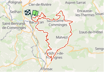
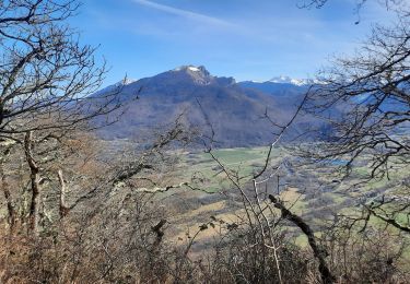
Trail Mountain bike of 48 km to be discovered at Occitania, Haute-Garonne, Barbazan. This trail is proposed by tracegps.

Description

4 Juin 2006 Partis « à la fraîche » de Toulouse, et malgré quelques honteux égarements autoroutiers (indice : on a aperçu le Pic du Midi !), nous arrivons comme prévu au petit lac de Barbazan vers 9h30.... La suite est ICI Source: FONF31

Elevation profile

Photos

Positioning

Country:
France
Region :
Occitania
Department/Province :
Haute-Garonne
Municipality :
Barbazan
Location:
Unknown
Start:(UTM)
305535 ; 4767693 (31T) N.

Trails nearby

Trail Walking Ardiège - Promenade autour d'Ardiège et de Cier de Rivière - Photo
Walking
tracegps

Walking

Easy
(1)
Ardiège, Occitania, Haute-Garonne, France
5 km | 6.4 km-effort
1h 15min
Yes
Trail Walking Saint-Bertrand-de-Comminges - Autour de Saint Bertrand de Comminges - Photo
Walking
tracegps

Walking

Difficult
(1)
Saint-Bertrand-de-Comminges, Occitania, Haute-Garonne, France
10.2 km | 17.1 km-effort
3h 30min
Yes
Trail Walking Seilhan - Tour de Seilhan - Photo
Walking
tracegps

Walking

Easy
(1)
Seilhan, Occitania, Haute-Garonne, France
5.9 km | 7.7 km-effort
1h 30min
Yes
Trail Walking Barbazan - Tour de Barbazan - Photo
Walking
tracegps

Walking

Easy
(2)
Barbazan, Occitania, Haute-Garonne, France
5.7 km | 7.3 km-effort
1h 30min
Yes
Trail Walking Antichan - sommet d'Herbe Rouge en boucle depuis Antichan  - Photo
Walking
GUIDE
lhomme.ph

Walking

Medium
Antichan, Occitania, Hautespyrenees, France
11.4 km | 20 km-effort
5h 47min
Yes
Trail On foot Saint-Bertrand-de-Comminges - Saint-Bertrand-de-Comminges : au coeur du Comminges - Photo
On foot
GUIDE+

On foot

Easy
Saint-Bertrand-de-Comminges, Occitania, Haute-Garonne, France
10.1 km | 17.1 km-effort
3h 52min
Yes
Trail Mountain bike Sauveterre-de-Comminges - sunday spin 8/6/14 - Photo
Mountain bike
ray23

Mountain bike

Difficult
(2)
Sauveterre-de-Comminges, Occitania, Haute-Garonne, France
18.2 km | 26 km-effort
2h 10min
Yes
Trail Walking Seilhan - bord de Garonne vers Labroquère  - Photo
Walking
GUIDE
lhomme.ph

Walking

Medium
Seilhan, Occitania, Haute-Garonne, France
9.5 km | 11.4 km-effort
2h 51min
Yes
Trail On foot Barbazan - BARBAZAN  le refuge saint-martin G3 Fait
On foot
GUIDE
marmotte65

On foot

Easy
Barbazan, Occitania, Haute-Garonne, France
11.2 km | 18.1 km-effort
3h 34min
Yes


Close
My subscriptions