![](/images/other/stat-length.png)
![Trail Mountain bike Brélès - Espace VTT FFC du Pays d'Iroise- Circuit n° 12 - Photo](https://media.geolcdn.com/t/1900/400/ext.pjpeg?maxdim=2&url=https%3A%2F%2Fservices.sitytrail.com%2FGeolivesWS%2FDownloadMedia.ashx%3FTrailID%3D100941%26Media%3D440_6.jpg)
Espace VTT FFC du Pays d'Iroise- Circuit n° 12
tracegps
User
![Length](/images/other/stat-length.png)
Length
65 km
![Max alt](https://static1.geolcdn.com/siteimages/upload/files/1508320355ic_sort_altitude_max_24dp.png)
Max alt
97 m
![Uphill gradient](https://static1.geolcdn.com/siteimages/upload/files/1508320355ic_sort_den_pos_24dp.png)
Uphill gradient
611 m
![Km-Effort](/images/other/stat-length.png)
Km-Effort
73 km
![Min alt](https://static1.geolcdn.com/siteimages/upload/files/1508320355ic_sort_altitude_min_24dp.png)
Min alt
2 m
![Downhill gradient](https://static1.geolcdn.com/siteimages/upload/files/1508320355ic_sort_den_neg_24dp.png)
Downhill gradient
610 m
![Boucle](https://static1.geolcdn.com/siteimages/upload/files/16400158638029165_repeat_loop_refresh_sync_direction_icon.png)
Boucle
Yes
Creation date :
2014-12-10 00:00:00.0
Updated on :
2014-12-10 00:00:00.0
![Mountain bike](https://static1.geolcdn.com/sitytour/trail-icons/202.png)
4h30
Difficulty : Very difficult
![Scan this QR Code to open this trail in the SityTrail application](https://capi.geolives.com/qq0zvz2zws4bq2lad0pu/sitytour/trails/100941/qr.png?size=200)
FREE GPS app for hiking
About
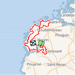
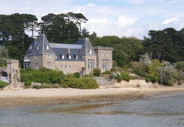
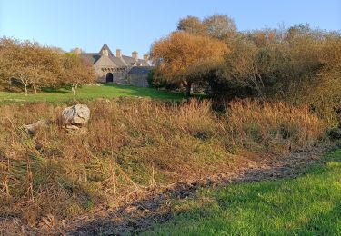
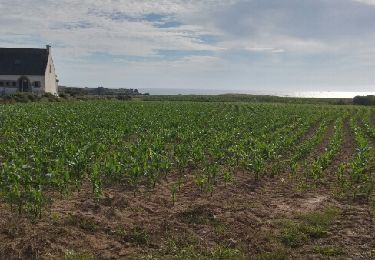
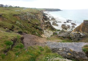
Trail Mountain bike of 65 km to be discovered at Brittany, Finistère, Brélès. This trail is proposed by tracegps.
Description
Espace VTT -FFC du Pays d’Iroise no 158 Circuit labellisé par la Fédération Française de Cyclisme. Relevé trace réalisé par Llegoff. Départ possible à Kersaint-Landunvez Combinaison des circuits n°8,9,10,11
Positioning
Country:
France
Region :
Brittany
Department/Province :
Finistère
Municipality :
Brélès
Location:
Unknown
Start:(Dec)
Start:(UTM)
373302 ; 5370886 (30U) N.
Comments
Trails nearby
![Trail Walking Lanildut - Autour de Lanildut - Photo](https://media.geolcdn.com/t/375/260/ext.jpg?maxdim=2&url=https%3A%2F%2Fservices.sitytrail.com%2FGeolivesWS%2FDownloadMedia.ashx%3FTrailID%3D112681%26Media%3D11473_5.jpg)
![Walking Walking](https://static1.geolcdn.com/sitytour/trail-icons/101.png)
Autour de Lanildut
Walking
Easy
(2)
Lanildut,
Brittany,
Finistère,
France
![](/images/other/stat-length.png)
7 km | 8 km-effort
1h 45min
![](https://static1.geolcdn.com/siteimages/upload/files/16400158638029165_repeat_loop_refresh_sync_direction_icon.png)
Yes
![Trail Walking Lampaul-Plouarzel - N°12a Lampaul-Plouarzel (Plage de Porspaul) - Conquet - Photo](https://media.geolcdn.com/t/375/260/ext.jpg?maxdim=2&url=https%3A%2F%2Fstatic1.geolcdn.com%2Fsiteimages%2Fupload%2Ffiles%2F1553511878bg_sport_marche.png)
![Walking Walking](https://static1.geolcdn.com/sitytour/trail-icons/101.png)
N°12a Lampaul-Plouarzel (Plage de Porspaul) - Conquet
Walking
Very difficult
(1)
Lampaul-Plouarzel,
Brittany,
Finistère,
France
![](/images/other/stat-length.png)
20 km | 24 km-effort
5h 29min
![](https://static1.geolcdn.com/siteimages/upload/files/16400158638029165_repeat_loop_refresh_sync_direction_icon.png)
No
![Trail Walking Lampaul-Plouarzel - 09.09.23 Lampaul- Plouarzel -- Le Conquet - Photo](https://media.geolcdn.com/t/375/260/888d86e8-0fc8-4dcf-a126-61bf014bddca.jpg&format=jpg&maxdim=2)
![Walking Walking](https://static1.geolcdn.com/sitytour/trail-icons/101.png)
09.09.23 Lampaul- Plouarzel -- Le Conquet
Walking
Very difficult
Lampaul-Plouarzel,
Brittany,
Finistère,
France
![](/images/other/stat-length.png)
21 km | 26 km-effort
5h 49min
![](https://static1.geolcdn.com/siteimages/upload/files/16400158638029165_repeat_loop_refresh_sync_direction_icon.png)
No
![Trail Walking Lampaul-Plouarzel - Lanpaul - Lochrist - Photo](https://media.geolcdn.com/t/375/260/ef6f4209-61ed-4c81-8584-8b20cf3e3c1d.jpg&format=jpg&maxdim=2)
![Walking Walking](https://static1.geolcdn.com/sitytour/trail-icons/101.png)
Lanpaul - Lochrist
Walking
Medium
Lampaul-Plouarzel,
Brittany,
Finistère,
France
![](/images/other/stat-length.png)
19.8 km | 24 km-effort
5h 7min
![](https://static1.geolcdn.com/siteimages/upload/files/16400158638029165_repeat_loop_refresh_sync_direction_icon.png)
No
![Trail Nordic walking Porspoder - porspoder - Photo](https://media.geolcdn.com/t/375/260/ca08756e-88ee-4f60-a720-df9bbcb94795.jpg&format=jpg&maxdim=2)
![Nordic walking Nordic walking](https://static1.geolcdn.com/sitytour/trail-icons/102.png)
porspoder
Nordic walking
Very easy
Porspoder,
Brittany,
Finistère,
France
![](/images/other/stat-length.png)
13.2 km | 14.4 km-effort
3h 13min
![](https://static1.geolcdn.com/siteimages/upload/files/16400158638029165_repeat_loop_refresh_sync_direction_icon.png)
Yes
![Trail Walking Lanildut - Aber Ildut - Tremazan - Photo](https://media.geolcdn.com/t/375/260/ext.jpg?maxdim=2&url=https%3A%2F%2Fservices.sitytrail.com%2FGeolivesWS%2FDownloadMedia.ashx%3FTrailID%3D968872%26Media%3Dfix__20180518160311.jpg)
![Walking Walking](https://static1.geolcdn.com/sitytour/trail-icons/101.png)
Aber Ildut - Tremazan
Walking
Easy
Lanildut,
Brittany,
Finistère,
France
![](/images/other/stat-length.png)
19.5 km | 22 km-effort
4h 42min
![](https://static1.geolcdn.com/siteimages/upload/files/16400158638029165_repeat_loop_refresh_sync_direction_icon.png)
No
![Trail Walking Porspoder - Circuit de la pointe Garchine par les terres. - Photo](https://media.geolcdn.com/t/375/260/ext.jpg?maxdim=2&url=https%3A%2F%2Fservices.sitytrail.com%2FGeolivesWS%2FDownloadMedia.ashx%3FTrailID%3D791378%26Media%3Dfix__20170717183807.jpg)
![Walking Walking](https://static1.geolcdn.com/sitytour/trail-icons/101.png)
Circuit de la pointe Garchine par les terres.
Walking
Very easy
(1)
Porspoder,
Brittany,
Finistère,
France
![](/images/other/stat-length.png)
9.3 km | 10.5 km-effort
2h 57min
![](https://static1.geolcdn.com/siteimages/upload/files/16400158638029165_repeat_loop_refresh_sync_direction_icon.png)
Yes
![Trail Walking Porspoder - GR 34 étape 32 - Photo](https://media.geolcdn.com/t/375/260/ext.jpg?maxdim=2&url=https%3A%2F%2Fservices.sitytrail.com%2FGeolivesWS%2FDownloadMedia.ashx%3FTrailID%3D318937%26Media%3Dfix__20140522170512.jpg)
![Walking Walking](https://static1.geolcdn.com/sitytour/trail-icons/101.png)
![Trail Walking Lanildut - Lanildut Porspoder - Photo](https://media.geolcdn.com/t/375/260/ext.jpg?maxdim=2&url=https%3A%2F%2Fstatic1.geolcdn.com%2Fsiteimages%2Fupload%2Ffiles%2F1553511878bg_sport_marche.png)
![Walking Walking](https://static1.geolcdn.com/sitytour/trail-icons/101.png)
Lanildut Porspoder
Walking
Medium
(1)
Lanildut,
Brittany,
Finistère,
France
![](/images/other/stat-length.png)
18.3 km | 21 km-effort
4h 34min
![](https://static1.geolcdn.com/siteimages/upload/files/16400158638029165_repeat_loop_refresh_sync_direction_icon.png)
Yes