Trail Mountain bike Fréjus - Roc d'Azur 2002 - Photo
 tracegps
tracegps

User

© OpenStreetMap contributors
Length
Length
44 km
Max alt
Max alt
238 m
Uphill gradient
Uphill gradient
1054 m
Km-Effort
Km-Effort  
58 km
Min alt
Min alt
-4 m
Downhill gradient
Downhill gradient
1054 m
Boucle
Boucle
No
Creation date :
2014-12-10 00:00:00.0
Updated on :
2014-12-10 00:00:00.0

(1 Reviews)

Mountain bike
Mountain bike
4h00
Difficulty : Very difficult

Scan this QR Code to open this trail in the SityTrail application

FREE GPS app for hiking

Logo SityTrail SityTrail

IGN / Geographical institutes

Download SityTrail from the App Store Download SityTrail from Google Play

Logo SityTrail SityTrail World

The world is yours!

Download SityTrail from the App Store Download SityTrail from Google Play Download SityTrail on Huawei AppGallery

About

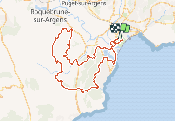
Trail Mountain bike of 44 km to be discovered at Provence-Alpes-Côte d'Azur, Var, Fréjus. This trail is proposed by tracegps.

Description

Depuis 1984, année de création du Roc d'Azur, cette épreuve est devenue l'épreuve reine du V.T.T. : Fréjus accueille le plus grand évènement européen clôturant la saison V.T.T. Le choix des tracés sur des parcours variés et magnifiques, des animations sur le site de la Base Nature, le premier salon du cycle français, en font un rendez-vous unique.(source ICI)

Elevation profile

Photos

Positioning

Country:
France
Region :
Provence-Alpes-Côte d'Azur
Department/Province :
Var
Municipality :
Fréjus
Location:
Unknown
Start:(UTM)
316500 ; 4809839 (32T) N.

Comments

Please log in to post a review or rate the element


Trails nearby

Trail Walking Fréjus - Etang de Villepey - Photo
Walking
marmotte83

Walking

Very easy
(2)
Fréjus, Provence-Alpes-Côte d'Azur, Var, France
6.5 km | 7 km-effort
3h 4min
Yes
Trail Mountain bike Fréjus - Roc Odyssée 2015 - Photo
Mountain bike
Dominick

Mountain bike

Medium
(1)
Fréjus, Provence-Alpes-Côte d'Azur, Var, France
37 km | 47 km-effort
3h 55min
No
Trail Walking Fréjus - VVA 2109 Etangs de Villepey - Photo
Walking
jmheydorff

Walking

Easy
(1)
Fréjus, Provence-Alpes-Côte d'Azur, Var, France
17 km | 19.6 km-effort
4h 13min
Yes
Trail Mountain bike Fréjus - Tour des Petites Maures - Photo
Mountain bike
barberou

Mountain bike

Very easy
(2)
Fréjus, Provence-Alpes-Côte d'Azur, Var, France
40 km | 52 km-effort
Unknown
Yes
Trail Walking Saint-Raphaël - dramont 12kms 206m - Photo
Walking
GUIDE
Danielba

Walking

Difficult
Saint-Raphaël, Provence-Alpes-Côte d'Azur, Var, France
11.9 km | 14.6 km-effort
5h 55min
No
Trail Walking Fréjus - petites maures  - Photo
Walking
Matamimi

Walking

Difficult
Fréjus, Provence-Alpes-Côte d'Azur, Var, France
12.9 km | 17.5 km-effort
4h 47min
No
Trail Walking Saint-Raphaël - sentier des douaniers Géologie/ Botanique - Photo
Walking
boulinevelyne

Walking

Medium
Saint-Raphaël, Provence-Alpes-Côte d'Azur, Var, France
6 km | 6.8 km-effort
1h 32min
No
Trail Walking Roquebrune-sur-Argens - La Bergerie - Piste des Clapiers - Bastide Abbe - Photo
Walking
LtZIP

Walking

Easy
Roquebrune-sur-Argens, Provence-Alpes-Côte d'Azur, Var, France
10.2 km | 13.4 km-effort
2h 39min
Yes
Trail Mountain bike Fréjus - 53 km Esterel - Photo
Mountain bike
donda

Mountain bike

Very difficult
Fréjus, Provence-Alpes-Côte d'Azur, Var, France
53 km | 67 km-effort
3h 16min
Yes


Close
My subscriptions