![](/images/other/stat-length.png)
![Trail Roller skating Les Sables-d'Olonne - Brem sur Mer à St Gilles Croix de Vie - Photo](https://media.geolcdn.com/t/1900/400/ext.pjpeg?maxdim=2&url=https%3A%2F%2Fservices.sitytrail.com%2FGeolivesWS%2FDownloadMedia.ashx%3FTrailID%3D100762%26Media%3D273_2.jpg)
Brem sur Mer à St Gilles Croix de Vie
tracegps
User
![Length](/images/other/stat-length.png)
Length
34 km
![Max alt](https://static1.geolcdn.com/siteimages/upload/files/1508320355ic_sort_altitude_max_24dp.png)
Max alt
26 m
![Uphill gradient](https://static1.geolcdn.com/siteimages/upload/files/1508320355ic_sort_den_pos_24dp.png)
Uphill gradient
204 m
![Km-Effort](/images/other/stat-length.png)
Km-Effort
37 km
![Min alt](https://static1.geolcdn.com/siteimages/upload/files/1508320355ic_sort_altitude_min_24dp.png)
Min alt
-2 m
![Downhill gradient](https://static1.geolcdn.com/siteimages/upload/files/1508320355ic_sort_den_neg_24dp.png)
Downhill gradient
207 m
![Boucle](https://static1.geolcdn.com/siteimages/upload/files/16400158638029165_repeat_loop_refresh_sync_direction_icon.png)
Boucle
No
Creation date :
2014-12-10 00:00:00.0
Updated on :
2014-12-10 00:00:00.0
![Roller skating](https://static1.geolcdn.com/sitytour/trail-icons/901.png)
3h00
Difficulty : Difficult
![Scan this QR Code to open this trail in the SityTrail application](https://capi.geolives.com/qq0zvz2zws4bq2lad0pu/sitytour/trails/100762/qr.png?size=200)
FREE GPS app for hiking
About
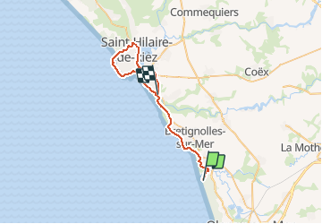
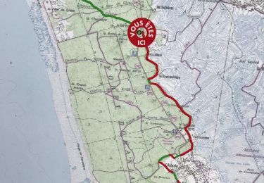
Trail Roller skating of 34 km to be discovered at Pays de la Loire, Vendée, Les Sables-d'Olonne. This trail is proposed by tracegps.
Description
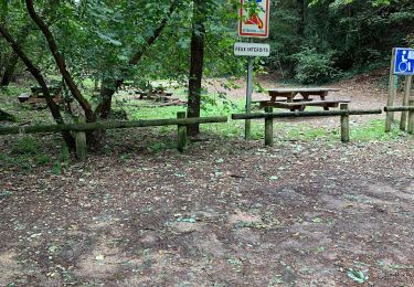
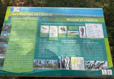
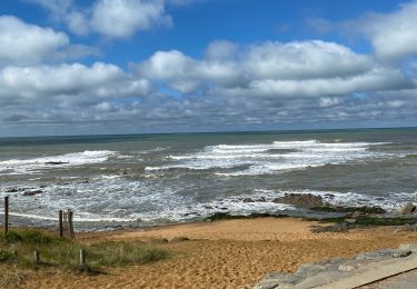
Départ du Havre de Gachère. Curiosités : dunes de la Garenne, plan d'eau de la Normandelière,Port de St Gilles Croix, ...
Positioning
Country:
France
Region :
Pays de la Loire
Department/Province :
Vendée
Municipality :
Les Sables-d'Olonne
Location:
Olonne-sur-Mer
Start:(Dec)
Start:(UTM)
588773 ; 5159562 (30T) N.
Comments
Trails nearby
![Trail Mountain bike L'Île-d'Olonne - Les marais de l'île d'Olonne - Le Jaunay - Photo](https://media.geolcdn.com/t/375/260/ext.jpg?maxdim=2&url=https%3A%2F%2Fservices.sitytrail.com%2FGeolivesWS%2FDownloadMedia.ashx%3FTrailID%3D129690%26Media%3D13226_2.jpg)
![Mountain bike Mountain bike](https://static1.geolcdn.com/sitytour/trail-icons/202.png)
Les marais de l'île d'Olonne - Le Jaunay
Mountain bike
Difficult
(2)
L'Île-d'Olonne,
Pays de la Loire,
Vendée,
France
![](/images/other/stat-length.png)
54 km | 63 km-effort
3h 30min
![](https://static1.geolcdn.com/siteimages/upload/files/16400158638029165_repeat_loop_refresh_sync_direction_icon.png)
Yes
![Trail Walking L'Île-d'Olonne - Sentier la fleur de sel - Photo](https://media.geolcdn.com/t/375/260/1ccf5a45-c40a-4459-b03e-737e931f1f29.jpg&format=jpg&maxdim=2)
![Walking Walking](https://static1.geolcdn.com/sitytour/trail-icons/101.png)
Sentier la fleur de sel
Walking
Very easy
L'Île-d'Olonne,
Pays de la Loire,
Vendée,
France
![](/images/other/stat-length.png)
5 km | 5.3 km-effort
1h 4min
![](https://static1.geolcdn.com/siteimages/upload/files/16400158638029165_repeat_loop_refresh_sync_direction_icon.png)
Yes
![Trail Other activity Les Sables-d'Olonne - rando Dudu 05-01-2019 - Photo](https://media.geolcdn.com/t/375/260/ext.jpg?maxdim=2&url=https%3A%2F%2Fservices.sitytrail.com%2FGeolivesWS%2FDownloadMedia.ashx%3FTrailID%3D1092695%26Media%3D20190105170235.jpg)
![Other activity Other activity](https://static1.geolcdn.com/sitytour/trail-icons/900.png)
rando Dudu 05-01-2019
Other activity
Very easy
Les Sables-d'Olonne,
Pays de la Loire,
Vendée,
France
![](/images/other/stat-length.png)
10.5 km | 11.5 km-effort
2h 19min
![](https://static1.geolcdn.com/siteimages/upload/files/16400158638029165_repeat_loop_refresh_sync_direction_icon.png)
Yes
![Trail Other activity Les Sables-d'Olonne - vert olonne - Photo](https://media.geolcdn.com/t/375/260/ext.jpg?maxdim=2&url=https%3A%2F%2Fservices.sitytrail.com%2FGeolivesWS%2FDownloadMedia.ashx%3FTrailID%3D684620%26Media%3Dfix__20170115104246.jpg)
![Other activity Other activity](https://static1.geolcdn.com/sitytour/trail-icons/900.png)
vert olonne
Other activity
Very easy
Les Sables-d'Olonne,
Pays de la Loire,
Vendée,
France
![](/images/other/stat-length.png)
18.7 km | 21 km-effort
2h 5min
![](https://static1.geolcdn.com/siteimages/upload/files/16400158638029165_repeat_loop_refresh_sync_direction_icon.png)
Yes
![Trail Walking Les Sables-d'Olonne - Forêt et Marais au Pays des Olonnes - Photo](https://media.geolcdn.com/t/375/260/ext.jpg?maxdim=2&url=https%3A%2F%2Fservices.sitytrail.com%2FGeolivesWS%2FDownloadMedia.ashx%3FTrailID%3D191330%26Media%3D14886_5.jpg)
![Walking Walking](https://static1.geolcdn.com/sitytour/trail-icons/101.png)
Forêt et Marais au Pays des Olonnes
Walking
Medium
Les Sables-d'Olonne,
Pays de la Loire,
Vendée,
France
![](/images/other/stat-length.png)
15.3 km | 16.7 km-effort
3h 30min
![](https://static1.geolcdn.com/siteimages/upload/files/16400158638029165_repeat_loop_refresh_sync_direction_icon.png)
Yes
![Trail Walking Les Sables-d'Olonne - Vendée_Sables-d'Olonne_Plage_de_Sauveterre - Photo](https://media.geolcdn.com/t/375/260/c681cc1a-daed-4477-9ef7-8159f743e858.jpg&format=jpg&maxdim=2)
![Walking Walking](https://static1.geolcdn.com/sitytour/trail-icons/101.png)
Vendée_Sables-d'Olonne_Plage_de_Sauveterre
Walking
Very easy
Les Sables-d'Olonne,
Pays de la Loire,
Vendée,
France
![](/images/other/stat-length.png)
4.6 km | 5.2 km-effort
1h 32min
![](https://static1.geolcdn.com/siteimages/upload/files/16400158638029165_repeat_loop_refresh_sync_direction_icon.png)
Yes
![Trail Walking Les Sables-d'Olonne - Didi tanbouille - Photo](https://media.geolcdn.com/t/375/260/fe2891ef-a20d-4463-b030-d3d920b96253.jpg&format=jpg&maxdim=2)
![Walking Walking](https://static1.geolcdn.com/sitytour/trail-icons/101.png)
Didi tanbouille
Walking
Very easy
Les Sables-d'Olonne,
Pays de la Loire,
Vendée,
France
![](/images/other/stat-length.png)
8.1 km | 8.8 km-effort
1h 49min
![](https://static1.geolcdn.com/siteimages/upload/files/16400158638029165_repeat_loop_refresh_sync_direction_icon.png)
Yes
![Trail Walking Les Sables-d'Olonne - Sentier Les Bourbes - Photo](https://media.geolcdn.com/t/375/260/16dadf7e-c56c-4289-a0bb-7fcf5a98618e.jpg&format=jpg&maxdim=2)
![Walking Walking](https://static1.geolcdn.com/sitytour/trail-icons/101.png)
Sentier Les Bourbes
Walking
Easy
Les Sables-d'Olonne,
Pays de la Loire,
Vendée,
France
![](/images/other/stat-length.png)
6.8 km | 7.4 km-effort
1h 40min
![](https://static1.geolcdn.com/siteimages/upload/files/16400158638029165_repeat_loop_refresh_sync_direction_icon.png)
Yes
![Trail Walking Les Sables-d'Olonne - Circuit Champclou - Photo](https://media.geolcdn.com/t/375/260/1ce1689f-b1d5-4eb7-bc94-9b3b713436b7.jpg&format=jpg&maxdim=2)
![Walking Walking](https://static1.geolcdn.com/sitytour/trail-icons/101.png)
Circuit Champclou
Walking
Les Sables-d'Olonne,
Pays de la Loire,
Vendée,
France
![](/images/other/stat-length.png)
10.4 km | 11.2 km-effort
2h 45min
![](https://static1.geolcdn.com/siteimages/upload/files/16400158638029165_repeat_loop_refresh_sync_direction_icon.png)
Yes