Trail Mountain bike Thuir - Fontcouverte 4 Déc 05 - Photo

Fontcouverte 4 Déc 05

 tracegps
tracegps

User

© OpenStreetMap contributors
Length
Length
38 km
Max alt
Max alt
577 m
Uphill gradient
Uphill gradient
968 m
Km-Effort
Km-Effort  
51 km
Min alt
Min alt
93 m
Downhill gradient
Downhill gradient
972 m
Boucle
Boucle
No
Creation date :
2014-12-10 00:00:00.0
Updated on :
2014-12-10 00:00:00.0

(0 Reviews)

Mountain bike
Mountain bike
3h13
Difficulty : Very difficult

Scan this QR Code to open this trail in the SityTrail application

FREE GPS app for hiking

Logo SityTrail SityTrail

IGN / Geographical institutes

Download SityTrail from the App Store Download SityTrail from Google Play

Logo SityTrail SityTrail World

The world is yours!

Download SityTrail from the App Store Download SityTrail from Google Play Download SityTrail on Huawei AppGallery

About

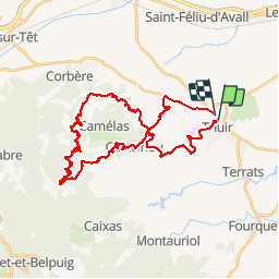
Trail Mountain bike of 38 km to be discovered at Occitania, Pyrénées-Orientales, Thuir. This trail is proposed by tracegps.

Description

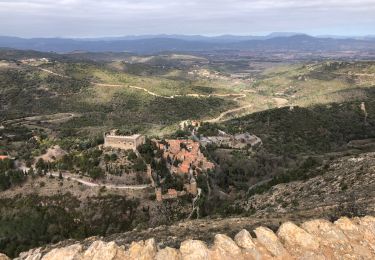
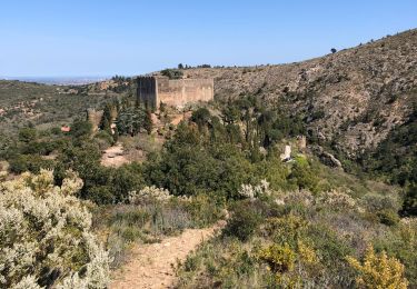
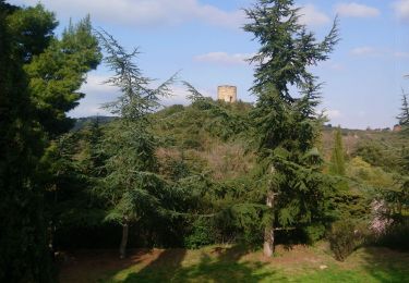
Belle randonnée dominicale organisée par le VTT club de Thuir. Quel plaisir de rouler en ce début décembre dans les Aspres sous un beau ciel bleu. La température au départ était assez basse, 5°C mais est montée assez rapidement à 16°C. Nous étions une bonne vingtaine au départ. Malgré le froid le rythme est vite monté. Le parcours était très varié avec de belles descentes techniques à fort dénivelé. J'ai eu parfois du mal à suivre car les deux à trois sorties hebdomadaire des membres du club de Thuir font la différence. Le paysage était superbe avec vue panoramique sur le Canigou et Néoulos enneigés. J'ai malheureusement constaté les dégats du dernier incendie entre Castelnou et Corbère. Si vous êtes un jour de passage à Thuir, le départ des randonnées ont lieu devant la mairie de Thuir tous les dimanche matin à 8H30 et est annoncé le samedi dans l'Indépendant.

Elevation profile

Positioning

Country:
France
Region :
Occitania
Department/Province :
Pyrénées-Orientales
Municipality :
Thuir
Location:
Unknown
Start:(UTM)
480027 ; 4720014 (31T) N.

Trails nearby

Trail Walking Llupia - 66 LLUPIA - FOURQUES - TERRATS promenade dans les ASPRES et son vignoble  - Photo
Walking
jeff66

Walking

Medium
(1)
Llupia, Occitania, Pyrénées-Orientales, France
15 km | 18.2 km-effort
2h 36min
Yes
Trail Walking Castelnou - CASTELNOU 66 -  CAMELAS - ermitage San Marti de La Roca - Photo
Walking
jeff66

Walking

Difficult
(1)
Castelnou, Occitania, Pyrénées-Orientales, France
10.8 km | 16.7 km-effort
2h 19min
Yes
Trail Walking Thuir - Thuir à Castelnou - Photo
Walking
timousse

Walking

Medium
(1)
Thuir, Occitania, Pyrénées-Orientales, France
14.1 km | 20 km-effort
4h 13min
Yes
Trail Walking Castelnou - Thuir  - Photo
Walking
Jean-François BALANGER

Walking

Very easy
(1)
Castelnou, Occitania, Pyrénées-Orientales, France
9.3 km | 12.1 km-effort
4h 4min
No
Trail Walking Castelnou - castel nous  - Photo
Walking
Jean-François BALANGER

Walking

Very easy
(1)
Castelnou, Occitania, Pyrénées-Orientales, France
11.9 km | 16.7 km-effort
4h 0min
Yes
Trail Walking Sainte-Colombe-de-la-Commanderie - THUIR 66 - Castelnou - Ste Colombe de la C. - Photo
Walking
jeff66

Walking

Medium
(2)
Sainte-Colombe-de-la-Commanderie, Occitania, Pyrénées-Orientales, France
14.8 km | 21 km-effort
2h 56min
Yes
Trail Walking Sainte-Colombe-de-la-Commanderie - 20230316 Sté Colombe-Castelnou - Photo
Walking
ThonyM

Walking

Medium
Sainte-Colombe-de-la-Commanderie, Occitania, Pyrénées-Orientales, France
16.3 km | 23 km-effort
3h 55min
Yes
Trail Walking Castelnou - 20210328 Castelnou-Camelas- boucl - Photo
Walking
ThonyM

Walking

Medium
Castelnou, Occitania, Pyrénées-Orientales, France
15.4 km | 23 km-effort
4h 1min
Yes
Trail Walking Castelnou - Autour de Castelnou via St Marti de la Roca  - Photo
Walking
zazie

Walking

Medium
Castelnou, Occitania, Pyrénées-Orientales, France
13.5 km | 21 km-effort
3h 11min
Yes


Close
My subscriptions