Trail Running Cambiac - De Cambiac à Auriac sur Vendinelle - Photo

De Cambiac à Auriac sur Vendinelle

 tracegps
tracegps

User

© OpenStreetMap contributors
Length
Length
17.2 km
Max alt
Max alt
263 m
Uphill gradient
Uphill gradient
209 m
Km-Effort
Km-Effort  
20 km
Min alt
Min alt
190 m
Downhill gradient
Downhill gradient
207 m
Boucle
Boucle
Yes
Creation date :
2014-12-10 00:00:00.0
Updated on :
2014-12-10 00:00:00.0

(0 Reviews)

Running
Running
1h40
Difficulty : Difficult

Scan this QR Code to open this trail in the SityTrail application

FREE GPS app for hiking

Logo SityTrail SityTrail

IGN / Geographical institutes

Download SityTrail from the App Store Download SityTrail from Google Play

Logo SityTrail SityTrail World

The world is yours!

Download SityTrail from the App Store Download SityTrail from Google Play Download SityTrail on Huawei AppGallery

About

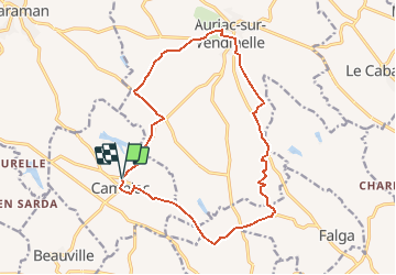
Trail Running of 17.2 km to be discovered at Occitania, Haute-Garonne, Cambiac. This trail is proposed by tracegps.

Description

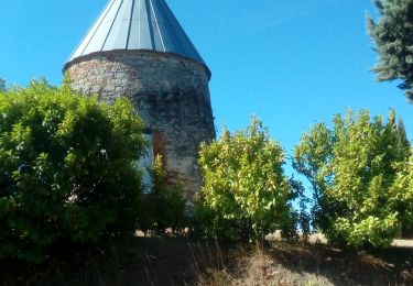
Circuit d'entrainement et de plaisir aux reliefs assez variés pour ne pas dormir ! PS: On ne passe pas au Moulin, mais il est joli !

Elevation profile

Photos

Positioning

Country:
France
Region :
Occitania
Department/Province :
Haute-Garonne
Municipality :
Cambiac
Location:
Unknown
Start:(UTM)
402416 ; 4816049 (31T) N.

Trails nearby

Trail Walking Toutens - 2-07-22 toutens - Photo
Walking
arnoultjf

Walking

Medium
Toutens, Occitania, Haute-Garonne, France
7 km | 7.9 km-effort
1h 49min
No
Trail On foot Vaux - circuit de la saune - Photo
On foot
GUIDE+

On foot

Easy
Vaux, Occitania, Haute-Garonne, France
15.9 km | 19.1 km-effort
4h 20min
No
Trail Walking Auriac-sur-Vendinelle - 16 février 2021 - Photo
Walking
arnoultjf

Walking

Very easy
Auriac-sur-Vendinelle, Occitania, Haute-Garonne, France
10.8 km | 13 km-effort
2h 50min
Yes
Trail Walking Vaux - Le Vaux 31 - Photo
Walking
Philplaisir

Walking

Easy
Vaux, Occitania, Haute-Garonne, France
22 km | 26 km-effort
2h 17min
No
Trail Walking Ségreville - Boucle du Pistouillé (Ségreville) - Photo
Walking
pidjam

Walking

Medium
Ségreville, Occitania, Haute-Garonne, France
12.3 km | 15 km-effort
3h 25min
Yes
Trail Walking Ségreville - Boucle du Pistouillé (Ségreville) - Photo
Walking
pidjam

Walking

Difficult
Ségreville, Occitania, Haute-Garonne, France
12.2 km | 15 km-effort
3h 15min
Yes
Trail Walking Vaux - 25 MARS 2019 - Photo
Walking
FLOCON

Walking

Medium
Vaux, Occitania, Haute-Garonne, France
10.4 km | 13 km-effort
2h 32min
Yes
Trail Walking Toutens - 18 MARS 2018 - Photo
Walking
FLOCON

Walking

Medium
Toutens, Occitania, Haute-Garonne, France
10.6 km | 12.4 km-effort
2h 24min
Yes
Trail Walking Vaux - 07 MAI 2018 - Photo
Walking
FLOCON

Walking

Medium
Vaux, Occitania, Haute-Garonne, France
11.6 km | 14.6 km-effort
2h 46min
Yes


Close
My subscriptions