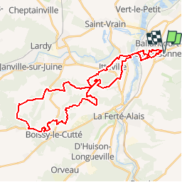
![](/images/other/stat-length.png)
![Trail Mountain bike Ballancourt-sur-Essonne - Verte Ballancourtoise 2006-35Km - Photo](https://media.geolcdn.com/t/1900/400/ext.pjpeg?maxdim=2&url=https%3A%2F%2Fstatic1.geolcdn.com%2Fsiteimages%2Fupload%2Ffiles%2F1524743154velo.jpg)
Verte Ballancourtoise 2006-35Km
tracegps
User
![Length](/images/other/stat-length.png)
![Max alt](https://static1.geolcdn.com/siteimages/upload/files/1508320355ic_sort_altitude_max_24dp.png)
![Uphill gradient](https://static1.geolcdn.com/siteimages/upload/files/1508320355ic_sort_den_pos_24dp.png)
![Km-Effort](/images/other/stat-length.png)
![Min alt](https://static1.geolcdn.com/siteimages/upload/files/1508320355ic_sort_altitude_min_24dp.png)
![Downhill gradient](https://static1.geolcdn.com/siteimages/upload/files/1508320355ic_sort_den_neg_24dp.png)
![Boucle](https://static1.geolcdn.com/siteimages/upload/files/16400158638029165_repeat_loop_refresh_sync_direction_icon.png)
![Mountain bike](https://static1.geolcdn.com/sitytour/trail-icons/202.png)
2h30
Difficulty : Difficult
![Scan this QR Code to open this trail in the SityTrail application](https://capi.geolives.com/qq0zvz2zws4bq2lad0pu/sitytour/trails/100703/qr.png?size=200)
FREE GPS app for hiking
About
Trail Mountain bike of 37 km to be discovered at Ile-de-France, Essonne, Ballancourt-sur-Essonne. This trail is proposed by tracegps.
Description
Il s'agit du circuit emprunté lors de la randonnée organisée par le club VTT de Ballancourt le 10/09/2006. Vous pouvez vous garer sur le stade de Ballancourt ou bien sur la place de l'église. Ce circuit traverse les marais d'Itteville, serpente dans les bois du côté de l'aérodrome de Cerny (La Fertée Allais), Orgemont, Boissy le Cutté, Villeneuve sur Auvers et Janville sur Juine. Il alterne quelques montées et descente en partie sur des sentiers monotraces et cumule environ 650m de dénivelé positif. Vous pourrez retrouver ce circuit au format IGN rando sur le site du club VTT (http://vttballancourt.free.fr/) dans la zone téléchargements
Positioning
Comments
Trails nearby
![Trail Walking Champcueil - JC 51 - 18,4 km - 320m - Champcueil, Les Grands Avaux - 23 km Effort - Photo](https://media.geolcdn.com/t/375/260/489ffccc-38be-45b9-b302-6ec46034b0a7.jpg&format=jpg&maxdim=2)
![Walking Walking](https://static1.geolcdn.com/sitytour/trail-icons/101.png)
Walking
![](/images/other/stat-length.png)
![](https://static1.geolcdn.com/siteimages/upload/files/16400158638029165_repeat_loop_refresh_sync_direction_icon.png)
![Trail Walking Itteville - Les vieilles ailes - Photo](https://media.geolcdn.com/t/375/260/401f9abb-572c-45de-a602-03e6caf0f1c1.jpg&format=jpg&maxdim=2)
![Walking Walking](https://static1.geolcdn.com/sitytour/trail-icons/101.png)
Walking
![](/images/other/stat-length.png)
![](https://static1.geolcdn.com/siteimages/upload/files/16400158638029165_repeat_loop_refresh_sync_direction_icon.png)
![Trail On foot Mennecy - Boucle 20 km autour de Mennecy - Photo](https://media.geolcdn.com/t/375/260/a0d84bba-b7da-4081-b724-5ae5c2d178d5.jpg&format=jpg&maxdim=2)
![On foot On foot](https://static1.geolcdn.com/sitytour/trail-icons/100.png)
On foot
![](/images/other/stat-length.png)
![](https://static1.geolcdn.com/siteimages/upload/files/16400158638029165_repeat_loop_refresh_sync_direction_icon.png)
![Trail Walking Ballancourt-sur-Essonne - Rando Ballancourt 15 km BM - Photo](https://media.geolcdn.com/t/375/260/8977c33c-1145-4a4f-97a7-a064e00deb0b.jpg&format=jpg&maxdim=2)
![Walking Walking](https://static1.geolcdn.com/sitytour/trail-icons/101.png)
Walking
![](/images/other/stat-length.png)
![](https://static1.geolcdn.com/siteimages/upload/files/16400158638029165_repeat_loop_refresh_sync_direction_icon.png)
![Trail Walking Mennecy - Boucle 23 km au départ de Mennecy - Photo](https://media.geolcdn.com/t/375/260/d9409c0b-4ad5-436d-94de-44694c25ec6a.jpg&format=jpg&maxdim=2)
![Walking Walking](https://static1.geolcdn.com/sitytour/trail-icons/101.png)
Walking
![](/images/other/stat-length.png)
![](https://static1.geolcdn.com/siteimages/upload/files/16400158638029165_repeat_loop_refresh_sync_direction_icon.png)
![Trail Walking Champcueil - Boucle Champcueil - Photo](https://media.geolcdn.com/t/375/260/7fb1af8d-34a9-45ce-aaee-3ffb4d1f1fed.jpg&format=jpg&maxdim=2)
![Walking Walking](https://static1.geolcdn.com/sitytour/trail-icons/101.png)
Walking
![](/images/other/stat-length.png)
![](https://static1.geolcdn.com/siteimages/upload/files/16400158638029165_repeat_loop_refresh_sync_direction_icon.png)
![Trail Walking Ballancourt-sur-Essonne - Boucle autour de Ballancourt - Photo](https://media.geolcdn.com/t/375/260/726c3226-57e6-4792-b7bd-15745463bf1c.jpg&format=jpg&maxdim=2)
![Walking Walking](https://static1.geolcdn.com/sitytour/trail-icons/101.png)
Walking
![](/images/other/stat-length.png)
![](https://static1.geolcdn.com/siteimages/upload/files/16400158638029165_repeat_loop_refresh_sync_direction_icon.png)
![Trail Walking Baulne - De La Ferté Alais à Mennecy - Photo](https://media.geolcdn.com/t/375/260/8fe2ded9-b4df-4cf6-bfbe-cc2b96524a28.jpg&format=jpg&maxdim=2)
![Walking Walking](https://static1.geolcdn.com/sitytour/trail-icons/101.png)
Walking
![](/images/other/stat-length.png)
![](https://static1.geolcdn.com/siteimages/upload/files/16400158638029165_repeat_loop_refresh_sync_direction_icon.png)
![Trail On foot Itteville - SityTrail - 3212203 - itteville - Photo](https://media.geolcdn.com/t/375/260/56ba6227-1e0d-415b-8a48-77e4f7fc1956.jpg&format=jpg&maxdim=2)
![On foot On foot](https://static1.geolcdn.com/sitytour/trail-icons/100.png)
On foot
![](/images/other/stat-length.png)
![](https://static1.geolcdn.com/siteimages/upload/files/16400158638029165_repeat_loop_refresh_sync_direction_icon.png)