![](/images/other/stat-length.png)
![Trail Running Garidech - La pêche à Garidech ! - Photo](https://media.geolcdn.com/t/1900/400/ext.pjpeg?maxdim=2&url=https%3A%2F%2Fstatic1.geolcdn.com%2Fsiteimages%2Fupload%2Ffiles%2F1524743154running.jpg)
La pêche à Garidech !
tracegps
User
![Length](/images/other/stat-length.png)
Length
11.4 km
![Max alt](https://static1.geolcdn.com/siteimages/upload/files/1508320355ic_sort_altitude_max_24dp.png)
Max alt
234 m
![Uphill gradient](https://static1.geolcdn.com/siteimages/upload/files/1508320355ic_sort_den_pos_24dp.png)
Uphill gradient
200 m
![Km-Effort](/images/other/stat-length.png)
Km-Effort
14.1 km
![Min alt](https://static1.geolcdn.com/siteimages/upload/files/1508320355ic_sort_altitude_min_24dp.png)
Min alt
139 m
![Downhill gradient](https://static1.geolcdn.com/siteimages/upload/files/1508320355ic_sort_den_neg_24dp.png)
Downhill gradient
200 m
![Boucle](https://static1.geolcdn.com/siteimages/upload/files/16400158638029165_repeat_loop_refresh_sync_direction_icon.png)
Boucle
Yes
Creation date :
2014-12-10 00:00:00.0
Updated on :
2014-12-10 00:00:00.0
![Running](https://static1.geolcdn.com/sitytour/trail-icons/103.png)
1h00
Difficulty : Medium
![Scan this QR Code to open this trail in the SityTrail application](https://capi.geolives.com/qq0zvz2zws4bq2lad0pu/sitytour/trails/100641/qr.png?size=200)
FREE GPS app for hiking
About
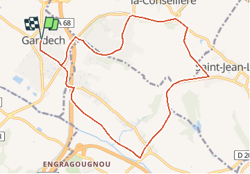
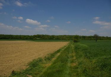
Trail Running of 11.4 km to be discovered at Occitania, Haute-Garonne, Garidech. This trail is proposed by tracegps.
Description
Agréable de relier ces 3 villages séparés par l'autoroute, amusant de passer de petites routes départementales à des chemins bien fréquentés autour d'une voie ferrée - ATTENTION, un train peut.....
Positioning
Country:
France
Region :
Occitania
Department/Province :
Haute-Garonne
Municipality :
Garidech
Location:
Unknown
Start:(Dec)
Start:(UTM)
384083 ; 4840532 (31T) N.
Comments
Trails nearby
![Trail Walking Gragnague - Tour de Bonrepos Riquet - Photo](https://media.geolcdn.com/t/375/260/ext.jpg?maxdim=2&url=https%3A%2F%2Fservices.sitytrail.com%2FGeolivesWS%2FDownloadMedia.ashx%3FTrailID%3D103417%26Media%3D5527_1.jpg)
![Walking Walking](https://static1.geolcdn.com/sitytour/trail-icons/101.png)
Tour de Bonrepos Riquet
Walking
Medium
(1)
Gragnague,
Occitania,
Haute-Garonne,
France
![](/images/other/stat-length.png)
9.7 km | 11.6 km-effort
2h 0min
![](https://static1.geolcdn.com/siteimages/upload/files/16400158638029165_repeat_loop_refresh_sync_direction_icon.png)
Yes
![Trail Cycle Garidech - Vélo route Garidech 46km - Photo](https://media.geolcdn.com/t/375/260/ext.jpg?maxdim=2&url=https%3A%2F%2Fstatic1.geolcdn.com%2Fsiteimages%2Fupload%2Ffiles%2F1524743154velo.jpg)
![Cycle Cycle](https://static1.geolcdn.com/sitytour/trail-icons/200.png)
Vélo route Garidech 46km
Cycle
Medium
(1)
Garidech,
Occitania,
Haute-Garonne,
France
![](/images/other/stat-length.png)
46 km | 51 km-effort
2h 0min
![](https://static1.geolcdn.com/siteimages/upload/files/16400158638029165_repeat_loop_refresh_sync_direction_icon.png)
Yes
![Trail On foot Gragnague - La rondes des berges - Photo](https://media.geolcdn.com/t/375/260/77c3b61f-a5a2-4a71-a28f-6562282b47d8.jpeg&format=jpg&maxdim=2)
![On foot On foot](https://static1.geolcdn.com/sitytour/trail-icons/100.png)
La rondes des berges
On foot
Easy
Gragnague,
Occitania,
Haute-Garonne,
France
![](/images/other/stat-length.png)
7.9 km | 8.5 km-effort
1h 55min
![](https://static1.geolcdn.com/siteimages/upload/files/16400158638029165_repeat_loop_refresh_sync_direction_icon.png)
Yes
![Trail Walking Gragnague - Ronde des berges Gragnagne - Photo](https://media.geolcdn.com/t/375/260/7bb35109-3b9e-478d-a3b8-289d2185834c.jpg&format=jpg&maxdim=2)
![Walking Walking](https://static1.geolcdn.com/sitytour/trail-icons/101.png)
Ronde des berges Gragnagne
Walking
Easy
Gragnague,
Occitania,
Haute-Garonne,
France
![](/images/other/stat-length.png)
8 km | 8.6 km-effort
2h 38min
![](https://static1.geolcdn.com/siteimages/upload/files/16400158638029165_repeat_loop_refresh_sync_direction_icon.png)
Yes
![Trail Walking Saint-Jean - Projet TT22 au départ de St Jean - Photo](https://media.geolcdn.com/t/375/260/5a219919-5176-472a-a689-aa98fab39714.jpg&format=jpg&maxdim=2)
![Walking Walking](https://static1.geolcdn.com/sitytour/trail-icons/101.png)
Projet TT22 au départ de St Jean
Walking
Medium
Saint-Jean,
Occitania,
Haute-Garonne,
France
![](/images/other/stat-length.png)
17.4 km | 19.6 km-effort
4h 0min
![](https://static1.geolcdn.com/siteimages/upload/files/16400158638029165_repeat_loop_refresh_sync_direction_icon.png)
No
![Trail Walking Saint-Jean - entre st jean et st geniès - Photo](https://media.geolcdn.com/t/375/260/ext.jpg?maxdim=2&url=https%3A%2F%2Fservices.sitytrail.com%2FGeolivesWS%2FDownloadMedia.ashx%3FTrailID%3D368190%26Media%3Dfix__20141207162221.jpg)
![Walking Walking](https://static1.geolcdn.com/sitytour/trail-icons/101.png)
entre st jean et st geniès
Walking
Medium
Saint-Jean,
Occitania,
Haute-Garonne,
France
![](/images/other/stat-length.png)
7.2 km | 8.3 km-effort
1h 51min
![](https://static1.geolcdn.com/siteimages/upload/files/16400158638029165_repeat_loop_refresh_sync_direction_icon.png)
Yes
![Trail Walking Paulhac - Le Bois de Buzet - Photo](https://media.geolcdn.com/t/375/260/ext.jpg?maxdim=2&url=https%3A%2F%2Fservices.sitytrail.com%2FGeolivesWS%2FDownloadMedia.ashx%3FTrailID%3D110326%26Media%3D5766_2.jpg)
![Walking Walking](https://static1.geolcdn.com/sitytour/trail-icons/101.png)
Le Bois de Buzet
Walking
Medium
Paulhac,
Occitania,
Haute-Garonne,
France
![](/images/other/stat-length.png)
7.5 km | 8.3 km-effort
2h 49min
![](https://static1.geolcdn.com/siteimages/upload/files/16400158638029165_repeat_loop_refresh_sync_direction_icon.png)
Yes
![Trail Walking Gragnague - Le Tour de Gragnague - Photo](https://media.geolcdn.com/t/375/260/ext.jpg?maxdim=2&url=https%3A%2F%2Fservices.sitytrail.com%2FGeolivesWS%2FDownloadMedia.ashx%3FTrailID%3D103419%26Media%3D5528_1.jpg)
![Walking Walking](https://static1.geolcdn.com/sitytour/trail-icons/101.png)
Le Tour de Gragnague
Walking
Medium
Gragnague,
Occitania,
Haute-Garonne,
France
![](/images/other/stat-length.png)
8.8 km | 9.5 km-effort
1h 45min
![](https://static1.geolcdn.com/siteimages/upload/files/16400158638029165_repeat_loop_refresh_sync_direction_icon.png)
Yes
![Trail Cycle Gragnague - Tour de Bonrepos Riquet - Photo](https://media.geolcdn.com/t/375/260/ext.jpg?maxdim=2&url=https%3A%2F%2Fservices.sitytrail.com%2FGeolivesWS%2FDownloadMedia.ashx%3FTrailID%3D103418%26Media%3D5527_1.jpg)
![Cycle Cycle](https://static1.geolcdn.com/sitytour/trail-icons/200.png)
Tour de Bonrepos Riquet
Cycle
Medium
Gragnague,
Occitania,
Haute-Garonne,
France
![](/images/other/stat-length.png)
9.7 km | 11.6 km-effort
1h 0min
![](https://static1.geolcdn.com/siteimages/upload/files/16400158638029165_repeat_loop_refresh_sync_direction_icon.png)
Yes