Trail Walking Saint-Vallier-de-Thiey - Col du Ferrier au Haut Montet - Photo
 LtZIP
LtZIP

User

© OpenStreetMap contributors
Length
Length
18.6 km
Max alt
Max alt
1411 m
Uphill gradient
Uphill gradient
785 m
Km-Effort
Km-Effort  
29 km
Min alt
Min alt
1039 m
Downhill gradient
Downhill gradient
783 m
Boucle
Boucle
Yes
Creation date :
2019-01-15 12:53:16.46
Updated on :
2021-02-13 17:28:12.037

(0 Reviews)

Walking
Walking
6h01
Difficulty : Difficult

Scan this QR Code to open this trail in the SityTrail application

FREE GPS app for hiking

Logo SityTrail SityTrail

IGN / Geographical institutes

Download SityTrail from the App Store Download SityTrail from Google Play

Logo SityTrail SityTrail World

The world is yours!

Download SityTrail from the App Store Download SityTrail from Google Play Download SityTrail on Huawei AppGallery

About

Trail Walking of 18.6 km to be discovered at Provence-Alpes-Côte d'Azur, Maritime Alps, Saint-Vallier-de-Thiey. This trail is proposed by LtZIP.

Description

Nombreux passages très caillouteux et non balisés entre le Haut Montet et le GR4.

Elevation profile

Photos

Positioning

Country:
France
Region :
Provence-Alpes-Côte d'Azur
Department/Province :
Maritime Alps
Municipality :
Saint-Vallier-de-Thiey
Location:
Unknown
Start:(UTM)
328026 ; 4842054 (32T) N.

Trails nearby

Trail Walking Grasse - petit rando au dessus de Grasse - Photo
Walking
patsure

Walking

Medium
(1)
Grasse, Provence-Alpes-Côte d'Azur, Maritime Alps, France
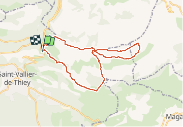
6 km | 10.6 km-effort
1h 55min
Yes
Trail Walking Caussols - Le Haut Montet 1335m, Plateau de Caussols - Photo
Walking
tracegps

Walking

Easy
(1)
Caussols, Provence-Alpes-Côte d'Azur, Maritime Alps, France
13.5 km | 18.6 km-effort
4h 0min
Yes
Trail Walking Saint-Vallier-de-Thiey - Arche de Ponadieu Source de la Pare Baou Mourine Vieux Pont  - Photo
Walking
GUIDE
jouans

Walking

Very difficult
Saint-Vallier-de-Thiey, Provence-Alpes-Côte d'Azur, Maritime Alps, France
19.2 km | 32 km-effort
7h 20min
Yes
Trail On foot Caussols - Plateau de Caussols - Photo
On foot
GUIDE+

On foot

Easy
Caussols, Provence-Alpes-Côte d'Azur, Maritime Alps, France
13.9 km | 19.1 km-effort
4h 20min
Yes
Trail On foot Grasse - Tour de la Marbrière - Photo
On foot
GUIDE+

On foot

Easy
Grasse, Provence-Alpes-Côte d'Azur, Maritime Alps, France
5.5 km | 10 km-effort
2h 16min
Yes
Trail Mountain bike Grasse - vttour_2051 - Photo
Mountain bike
Reich

Mountain bike

Medium
(1)
Grasse, Provence-Alpes-Côte d'Azur, Maritime Alps, France
18.5 km | 27 km-effort
1h 42min
Yes
Trail Walking Caussols - La Meute Plateau de Caussols 3 - Photo
Walking
DIDIERLESERT

Walking

Medium
(1)
Caussols, Provence-Alpes-Côte d'Azur, Maritime Alps, France
12.4 km | 17.2 km-effort
4h 0min
Yes
Trail Walking Saint-Vallier-de-Thiey - Grasse - Montagne de Thiey - Photo
Walking
GUIDE
Orcal37

Walking

Medium
Saint-Vallier-de-Thiey, Provence-Alpes-Côte d'Azur, Maritime Alps, France
14.9 km | 25 km-effort
4h 54min
Yes
Trail Walking Caussols - La Meute Plateau de Caussols - Photo
Walking
DIDIERLESERT

Walking

Medium
(1)
Caussols, Provence-Alpes-Côte d'Azur, Maritime Alps, France
14.9 km | 20 km-effort
4h 17min
Yes


Close
My subscriptions