Home
World
NEW
Premium
Shop
Trails
Articles
Help and support
Français
English
Nederlands
Español
Italiano
Deutsch
Log in
Home
World
Premium
Shop
Trails
Articles
Help and support
SityTrail
>
Points of interest
>
Chemin137
SityTrail
>
Points of interest
>
Chemin137
Chemin137
Description
Latitude: 48.1116950512 Longitude : 7.2730243206
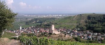
Photos
Chemin137 can be discovered in the following trails...
DoBelle
Trois Epis 1
Walking
Medium
Ammerschwihr, Grand Est, Haut-Rhin, France
19.1 km | 30 km-effort
Unknown
No
DoBelle
User
©
OpenStreetMap
contributors
Positioning
Country:
France
Region :
Grand Est
Department/Province :
Haut-Rhin
Municipality :
Ammerschwihr
Location:
Unknown
Positioning
48.1116950512 / 7.2730243206
Creation date :
2018-04-12 23:48:25.318
Updated on
2018-04-12 23:48:25.318
(0 Reviews)
Comments
Please log in to post a review or rate the element
Points of interest nearby
DoBelle
Allée et Chemin83
KATZENTHAL
zazie
Point 7 -Katzenthal et le c...
KATZENTHAL
DoBelle
Route et Che Du Chateau
KATZENTHAL
DoBelle
Allée et Chemin82
KATZENTHAL
tracegps
004
KATZENTHAL
Tourisme Equestre Alsace
Wineck Kaysersberg - Incont...
KATZENTHAL
DoBelle
Wineck
KATZENTHAL
DoBelle
Wineck
KATZENTHAL
Close
My subscriptions