Home
World
NEW
Premium
Shop
Trails
Articles
Help and support
Français
English
Nederlands
Español
Italiano
Deutsch
Log in
Home
World
Premium
Shop
Trails
Articles
Help and support
SityTrail
>
Points of interest
>
départ
SityTrail
>
Points of interest
>
départ
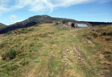
départ
Description
Route
Photos
départ can be discovered in the following trails...
tracegps
De Murat à St. Jacques des Blats
Walking
Difficult
Murat, Auvergne-Rhône-Alpes, Cantal, France
25 km | 39 km-effort
7h 0min
No
tracegps
User
©
OpenStreetMap
contributors
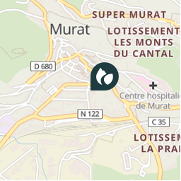
Positioning
Country:
France
Region :
Auvergne-Rhône-Alpes
Department/Province :
Cantal
Municipality :
Murat
Location:
Murat
Positioning
45.1105714 / 2.8692871
Creation date :
2018-04-09 12:09:38.597
Updated on
2018-04-09 12:09:38.597
(0 Reviews)
Comments
Please log in to post a review or rate the element
Points of interest nearby
tracegps
départ
MURAT
tracegps
départ
LAVEISSIÈRE
tracegps
2
LAVEISSENET
tracegps
départ
LAVEISSIÈRE
tracegps
1
LAVEISSENET
tracegps
départ
LAVEISSENET
tracegps
2
LAVEISSENET
tracegps
1
LAVEISSENET
Close
My subscriptions