Home
World
NEW
Premium
Shop
Trails
Articles
Help and support
Français
English
Nederlands
Español
Italiano
Deutsch
Log in
Home
World
Premium
Shop
Trails
Articles
Help and support
SityTrail
>
Points of interest
>
Départ
SityTrail
>
Points of interest
>
Départ
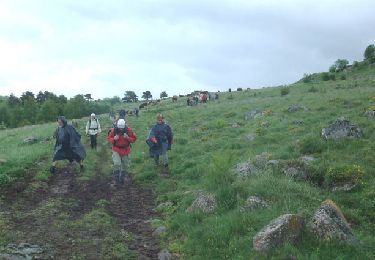
Départ
Description
Chemin
Photos
Départ can be discovered in the following trails...
tracegps
De Fortuniès à Chastel sur Murat via le Lac du Pêcher
Walking
Difficult
Dienne, Auvergne-Rhône-Alpes, Cantal, France
26 km | 33 km-effort
7h 0min
No
tracegps
User
©
OpenStreetMap
contributors
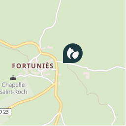
Positioning
Country:
France
Region :
Auvergne-Rhône-Alpes
Department/Province :
Cantal
Municipality :
Dienne
Location:
Unknown
Positioning
45.1886232 / 2.8607499
Creation date :
2018-04-09 12:10:42.265
Updated on
2018-04-09 12:10:42.265
(0 Reviews)
Comments
Please log in to post a review or rate the element
Points of interest nearby
tracegps
départ
DIENNE
tracegps
Autre départ
NEUSSARGUES EN PINATELLE
tracegps
B
VERNOLS
tracegps
A
VERNOLS
tracegps
4
NEUSSARGUES EN PINATELLE
tracegps
3
NEUSSARGUES EN PINATELLE
tracegps
Roche Du Pic
NEUSSARGUES EN PINATELLE
tracegps
Roche Du Pic1
NEUSSARGUES EN PINATELLE
Close
My subscriptions