Home
World
NEW
Premium
Shop
Trails
Articles
Help and support
Français
English
Nederlands
Español
Italiano
Deutsch
Log in
Home
World
Premium
Shop
Trails
Articles
Help and support
SityTrail
>
Points of interest
>
STATION
SityTrail
>
Points of interest
>
STATION
STATION
Description
19-JUIL-08 16:47:42
Photos
STATION can be discovered in the following trails...
tracegps
Mine du Rancié
Mountain bike
Difficult
Val-de-Sos, Occitania, Ariège, France
22 km | 37 km-effort
3h 0min
Yes
tracegps
User
©
OpenStreetMap
contributors
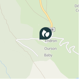
Positioning
Country:
France
Region :
Occitania
Department/Province :
Ariège
Municipality :
Val-de-Sos
Location:
Goulier
Positioning
42.739367 / 1.513466
Creation date :
2018-04-09 12:22:18.724
Updated on
2018-04-09 12:22:18.724
(0 Reviews)
Comments
Please log in to post a review or rate the element
Points of interest nearby
philou6351
Route et Chemin
VAL-DE-SOS
philou6351
Chemin
VAL-DE-SOS
philou6351
Cours d'Eau intermittent
VAL-DE-SOS
philou6351
001
VAL-DE-SOS
philou6351
002
VAL-DE-SOS
philou6351
003
VAL-DE-SOS
philou6351
Sentier
VAL-DE-SOS
philou6351
004
VAL-DE-SOS
Close
My subscriptions