Point of interest Vialas - Histoire: Architecture du paysage - Photo

Histoire: Architecture du paysage

Description

<p>Soutenant des terrasses appel&eacute;es &nbsp;&laquo; bancels &raquo; ou &laquo; fa&iuml;sses &raquo;, o&ugrave; on cultivait des fruits et des l&eacute;gumes, du seigle et des ch&acirc;taigniers, ces murs retenaient la terre et orientaient l&rsquo;eau de ruissellement. Plus haut, des pr&eacute;s pentus fauch&eacute;s &agrave; la main fournissaient le foin que l&rsquo;on descendait dans les hameaux, au XIXe si&egrave;cle, au moyen de c&acirc;bles.</p>
<p>Panneau n&deg;9</p>

Photos

Histoire: Architecture du paysage can be discovered in the following trails...
Trail Walking Vialas - gourdouze - Photo
Walking
aurel69

Walking

Medium
(1)
Vialas, Occitania, Lozère, France
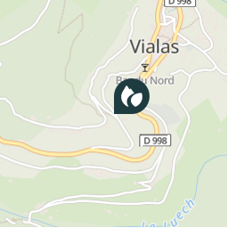
13.7 km | 25 km-effort
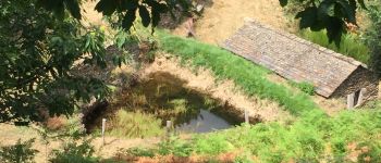
Unknown
Yes
 aurel69
aurel69

User

© OpenStreetMap contributors

Positioning

Country:
France
Region :
Occitania
Department/Province :
Lozère
Municipality :
Vialas
Location:
Unknown
Creation date :
2019-05-06 12:01:59.374
Updated on
2019-05-06 12:01:59.374

(0 Reviews)


Points of interest nearby

Point of interest Vialas - Eau: Eau - Photo
aurel69
VIALAS 
Point of interest Vialas - ancien moulin - Photo
alfreson
Point of interest Vialas - ancien moulin - Photo
alfreson
Point of interest Vialas - Unnamed POI - Photo
David Virebayre
VIALAS 
Point of interest Vialas - Histoire: Gourdouze - Photo
aurel69


Close
My subscriptions