Gandino, Bergamo: Best trails, routes and walks

Gandino: Discover the best trails: 2 hiking trails. All these trails, routes and outdoor activities are available in our SityTrail applications for smartphones and tablets.


The best trails (2)

Trail On foot Gandino - Barzizza di Gandino - Monte di Sovere - Photo
On foot 8.397
Km
PRO

On foot

Easy
Gandino, Lombardy, Bergamo, Italy
8.4 km | 11.9 km-effort
2h 42min
252 m
309 m
No
SityTrail - itinéraires balisés pédestres

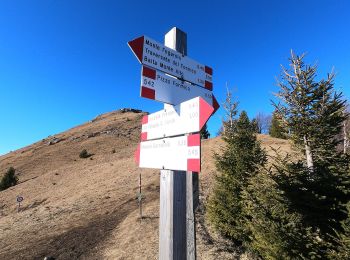
• Trail created by Comunità montana Valle Seriana. Symbol: red-white-red vertical bars with black 545

Trail On foot Gandino - Barzizza – Tribulina di Guazza – Capanna Ilaria – Pizzo Formico - Photo
On foot 4.598
Km
PRO

On foot

Easy
Gandino, Lombardy, Bergamo, Italy
4.6 km | 12.1 km-effort
2h 45min
752 m
0 m
No
SityTrail - itinéraires balisés pédestres

• Trail created by Comunità montana Valle Seriana. Symbol: white-red horizontal bars, sometimes with black text "549"

2 trails displayed on 2

FREE GPS app for hiking

Logo SityTrail SityTrail

IGN / Geographical institutes

Download SityTrail from the App Store Download SityTrail from Google Play

Logo SityTrail SityTrail World

The world is yours!

Download SityTrail from the App Store Download SityTrail from Google Play Download SityTrail on Huawei AppGallery

Activities

Close
My subscriptions