![](/images/other/stat-length.png)
Erbezzo, Verona: Best trails, routes and walks
Erbezzo: Discover the best trails: 9 hiking trails. All these trails, routes and outdoor activities are available in our SityTrail applications for smartphones and tablets.
The best trails (9)
![Trail On foot Erbezzo - Vajo dell'Anguilla inn. 256 - Località Pontare inn. 257 - Photo](https://media.geolcdn.com/t/350/260/dc05b2fe-9169-4b99-a7db-23c806b6f672.jpeg&format=jpg&maxdim=2)
![On foot On foot](https://static1.geolcdn.com/sitytour/trail-icons/100.png)
Km
On foot
![](/images/other/stat-length.png)
![](https://static1.geolcdn.com/siteimages/upload/files/1508320355ic_sort_den_pos_24dp.png)
![](https://static1.geolcdn.com/siteimages/upload/files/1508320355ic_sort_den_neg_24dp.png)
![](https://static1.geolcdn.com/siteimages/upload/files/16400158638029165_repeat_loop_refresh_sync_direction_icon.png)
• Trail created by Club Alpino Italiano Sezione di Bosco Chiesanuova. Symbol: 248 on white red flag Website: http://...
![Trail On foot Erbezzo - Dorsale Media della Lessinia - sezione Bernardi-Perii - Photo](https://media.geolcdn.com/t/350/260/a8c0a9df-6f17-4400-a005-59d56ad0f479.jpeg&format=jpg&maxdim=2)
![On foot On foot](https://static1.geolcdn.com/sitytour/trail-icons/100.png)
Km
On foot
![](/images/other/stat-length.png)
![](https://static1.geolcdn.com/siteimages/upload/files/1508320355ic_sort_den_pos_24dp.png)
![](https://static1.geolcdn.com/siteimages/upload/files/1508320355ic_sort_den_neg_24dp.png)
![](https://static1.geolcdn.com/siteimages/upload/files/16400158638029165_repeat_loop_refresh_sync_direction_icon.png)
• Trail created by Club Alpino Italiano Sezione di San Pietro in Cariano. relation mantained by Club Alpino Italiano S...
![Trail On foot Erbezzo - Avesa - Bivio del Piòcio inn. sent. 250 - Photo](https://media.geolcdn.com/t/350/260/bb246d0e-8611-4b4f-8da8-742c0fc181af.jpeg&format=jpg&maxdim=2)
![On foot On foot](https://static1.geolcdn.com/sitytour/trail-icons/100.png)
Km
On foot
![](/images/other/stat-length.png)
![](https://static1.geolcdn.com/siteimages/upload/files/1508320355ic_sort_den_pos_24dp.png)
![](https://static1.geolcdn.com/siteimages/upload/files/1508320355ic_sort_den_neg_24dp.png)
![](https://static1.geolcdn.com/siteimages/upload/files/16400158638029165_repeat_loop_refresh_sync_direction_icon.png)
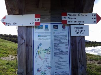
• Symbol: 257 on white red flag
![Trail On foot Erbezzo - Erbezzo - Bivio del Piòcio inn. sent. 250 - Photo](https://media.geolcdn.com/t/350/260/15622d23-d5bf-44f0-8144-74dd1511bca6.jpeg&format=jpg&maxdim=2)
![On foot On foot](https://static1.geolcdn.com/sitytour/trail-icons/100.png)
Km
On foot
![](/images/other/stat-length.png)
![](https://static1.geolcdn.com/siteimages/upload/files/1508320355ic_sort_den_pos_24dp.png)
![](https://static1.geolcdn.com/siteimages/upload/files/1508320355ic_sort_den_neg_24dp.png)
![](https://static1.geolcdn.com/siteimages/upload/files/16400158638029165_repeat_loop_refresh_sync_direction_icon.png)
• Trail created by Club Alpino Italiano Sezione di Bosco Chiesanuova.
![Trail On foot Erbezzo - Dorsale Alta della Lessinia tratto Parparo di Sopra - Passo Fittanze - Photo](https://media.geolcdn.com/t/350/260/cb54e536-35e4-4e19-ace6-4e6223d7511e.jpeg&format=jpg&maxdim=2)
![On foot On foot](https://static1.geolcdn.com/sitytour/trail-icons/100.png)
Km
On foot
![](/images/other/stat-length.png)
![](https://static1.geolcdn.com/siteimages/upload/files/1508320355ic_sort_den_pos_24dp.png)
![](https://static1.geolcdn.com/siteimages/upload/files/1508320355ic_sort_den_neg_24dp.png)
![](https://static1.geolcdn.com/siteimages/upload/files/16400158638029165_repeat_loop_refresh_sync_direction_icon.png)
• Trail created by Club Alpino Italiano Sezione di Bosco Chiesanuova. relation mantained by Club Alpino Italiano Sezio...
![Trail On foot Erbezzo - Itinerario Azzurro - Photo](https://media.geolcdn.com/t/350/260/15622d23-d5bf-44f0-8144-74dd1511bca6.jpeg&format=jpg&maxdim=2)
![On foot On foot](https://static1.geolcdn.com/sitytour/trail-icons/100.png)
Km
On foot
![](/images/other/stat-length.png)
![](https://static1.geolcdn.com/siteimages/upload/files/1508320355ic_sort_den_pos_24dp.png)
![](https://static1.geolcdn.com/siteimages/upload/files/1508320355ic_sort_den_neg_24dp.png)
![](https://static1.geolcdn.com/siteimages/upload/files/16400158638029165_repeat_loop_refresh_sync_direction_icon.png)
• Trail created by Comune di Erbezzo.
![Trail On foot Erbezzo - Itinerario Arancio - Photo](https://media.geolcdn.com/t/350/260/15622d23-d5bf-44f0-8144-74dd1511bca6.jpeg&format=jpg&maxdim=2)
![On foot On foot](https://static1.geolcdn.com/sitytour/trail-icons/100.png)
Km
On foot
![](/images/other/stat-length.png)
![](https://static1.geolcdn.com/siteimages/upload/files/1508320355ic_sort_den_pos_24dp.png)
![](https://static1.geolcdn.com/siteimages/upload/files/1508320355ic_sort_den_neg_24dp.png)
![](https://static1.geolcdn.com/siteimages/upload/files/16400158638029165_repeat_loop_refresh_sync_direction_icon.png)
• Trail created by Comune di Erbezzo.
![Trail On foot Erbezzo - Sentiero n. 3 - Malga Lessinia - Photo](https://media.geolcdn.com/t/350/260/01c5994a-48a4-4899-9af3-20dc0c67fb93.jpeg&format=jpg&maxdim=2)
![On foot On foot](https://static1.geolcdn.com/sitytour/trail-icons/100.png)
Km
On foot
![](/images/other/stat-length.png)
![](https://static1.geolcdn.com/siteimages/upload/files/1508320355ic_sort_den_pos_24dp.png)
![](https://static1.geolcdn.com/siteimages/upload/files/1508320355ic_sort_den_neg_24dp.png)
![](https://static1.geolcdn.com/siteimages/upload/files/16400158638029165_repeat_loop_refresh_sync_direction_icon.png)
• Trail created by Parco Naturale Regionale della Lessinia.
![Trail On foot Erbezzo - Sentiero n. 2 - Vajo dell'Anguilla - Photo](https://media.geolcdn.com/t/350/260/dc05b2fe-9169-4b99-a7db-23c806b6f672.jpeg&format=jpg&maxdim=2)
![On foot On foot](https://static1.geolcdn.com/sitytour/trail-icons/100.png)
Km
On foot
![](/images/other/stat-length.png)
![](https://static1.geolcdn.com/siteimages/upload/files/1508320355ic_sort_den_pos_24dp.png)
![](https://static1.geolcdn.com/siteimages/upload/files/1508320355ic_sort_den_neg_24dp.png)
![](https://static1.geolcdn.com/siteimages/upload/files/16400158638029165_repeat_loop_refresh_sync_direction_icon.png)
• Trail created by Parco Naturale Regionale della Lessinia.
9 trails displayed on 9
FREE GPS app for hiking