![](/images/other/stat-length.png)
- Trails
- Outdoor
- France
- Hauts-de-France
- Nord
- Les Rues-des-Vignes
Les Rues-des-Vignes, Nord: Best trails, routes and walks
1 comments
Les Rues-des-Vignes: Discover the best trails: 5 hiking trails. All these trails, routes and outdoor activities are available in our SityTrail applications for smartphones and tablets.
The best trails (5)
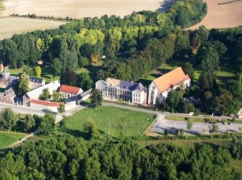
![Trail Walking Les Rues-des-Vignes - Abbaye de Vaucelles - Photo](https://media.geolcdn.com/t/350/260/30100122-fb7e-4ae3-8390-4ffe12cccfaa.jpg&format=jpg&maxdim=2)
![Walking Walking](https://static1.geolcdn.com/sitytour/trail-icons/101.png)
Km
#1 - Abbaye de Vaucelles
Walking
Medium
Les Rues-des-Vignes,
Hauts-de-France,
Nord,
France
![](/images/other/stat-length.png)
22 km | 25 km-effort
5h 39min
![](https://static1.geolcdn.com/siteimages/upload/files/1508320355ic_sort_den_pos_24dp.png)
205 m
![](https://static1.geolcdn.com/siteimages/upload/files/1508320355ic_sort_den_neg_24dp.png)
205 m
![](https://static1.geolcdn.com/siteimages/upload/files/16400158638029165_repeat_loop_refresh_sync_direction_icon.png)
Yes
Greg813
![Trail Walking Les Rues-des-Vignes - Saint Jacques en Boulangrie - Abbayte de Vaucelles - Honnecourt sur Escaut - Photo](https://media.geolcdn.com/t/350/260/ext.jpg?maxdim=2&url=https%3A%2F%2Fservices.sitytrail.com%2FGeolivesWS%2FDownloadMedia.ashx%3FTrailID%3D112608%26Media%3D11124_1.jpg)
![Walking Walking](https://static1.geolcdn.com/sitytour/trail-icons/101.png)
Km
#2 - Saint Jacques en Boulangrie - Abbayte de Vaucelles - Honnecourt sur Escaut
Walking
Medium
Les Rues-des-Vignes,
Hauts-de-France,
Nord,
France
![](/images/other/stat-length.png)
6.4 km | 6.8 km-effort
1h 30min
![](https://static1.geolcdn.com/siteimages/upload/files/1508320355ic_sort_den_pos_24dp.png)
35 m
![](https://static1.geolcdn.com/siteimages/upload/files/1508320355ic_sort_den_neg_24dp.png)
29 m
![](https://static1.geolcdn.com/siteimages/upload/files/16400158638029165_repeat_loop_refresh_sync_direction_icon.png)
No
tracegps
![Trail Walking Les Rues-des-Vignes - Un détour par Honnecourt - Abbaye de Vaucelles - Photo](https://media.geolcdn.com/t/350/260/ext.jpg?maxdim=2&url=https%3A%2F%2Fservices.sitytrail.com%2FGeolivesWS%2FDownloadMedia.ashx%3FTrailID%3D109807%26Media%3D4748_4.jpg)
![Walking Walking](https://static1.geolcdn.com/sitytour/trail-icons/101.png)
Km
#3 - Un détour par Honnecourt - Abbaye de Vaucelles
Walking
Very difficult
(1)
Les Rues-des-Vignes,
Hauts-de-France,
Nord,
France
![](/images/other/stat-length.png)
18 km | 21 km-effort
6h 0min
![](https://static1.geolcdn.com/siteimages/upload/files/1508320355ic_sort_den_pos_24dp.png)
201 m
![](https://static1.geolcdn.com/siteimages/upload/files/1508320355ic_sort_den_neg_24dp.png)
199 m
![](https://static1.geolcdn.com/siteimages/upload/files/16400158638029165_repeat_loop_refresh_sync_direction_icon.png)
Yes
tracegps
![Trail Walking Les Rues-des-Vignes - Vaucelles 12.3Km Dén P 150m - Photo](https://media.geolcdn.com/t/350/260/ext.jpg?maxdim=2&url=https%3A%2F%2Fstatic1.geolcdn.com%2Fsiteimages%2Fupload%2Ffiles%2F1553511878bg_sport_marche.png)
![Walking Walking](https://static1.geolcdn.com/sitytour/trail-icons/101.png)
Km
#4 - Vaucelles 12.3Km Dén P 150m
Walking
Easy
Les Rues-des-Vignes,
Hauts-de-France,
Nord,
France
![](/images/other/stat-length.png)
12.3 km | 14.3 km-effort
2h 14min
![](https://static1.geolcdn.com/siteimages/upload/files/1508320355ic_sort_den_pos_24dp.png)
150 m
![](https://static1.geolcdn.com/siteimages/upload/files/1508320355ic_sort_den_neg_24dp.png)
148 m
![](https://static1.geolcdn.com/siteimages/upload/files/16400158638029165_repeat_loop_refresh_sync_direction_icon.png)
Yes
alain62rando
![Trail Walking Les Rues-des-Vignes - circuit de vaucelles - Photo](https://media.geolcdn.com/t/350/260/ext.jpg?maxdim=2&url=https%3A%2F%2Fstatic1.geolcdn.com%2Fsiteimages%2Fupload%2Ffiles%2F1553511878bg_sport_marche.png)
![Walking Walking](https://static1.geolcdn.com/sitytour/trail-icons/101.png)
Km
#5 - circuit de vaucelles
Walking
Difficult
Les Rues-des-Vignes,
Hauts-de-France,
Nord,
France
![](/images/other/stat-length.png)
12.4 km | 14.4 km-effort
3h 6min
![](https://static1.geolcdn.com/siteimages/upload/files/1508320355ic_sort_den_pos_24dp.png)
149 m
![](https://static1.geolcdn.com/siteimages/upload/files/1508320355ic_sort_den_neg_24dp.png)
148 m
![](https://static1.geolcdn.com/siteimages/upload/files/16400158638029165_repeat_loop_refresh_sync_direction_icon.png)
Yes
cannelle
5 trails displayed on 5
FREE GPS app for hiking