![](/images/other/stat-length.png)
Lleida, Catalonia: Best trails, routes and walks
Lleida: Discover the best trails: 278 hiking trails and 4 bike and mountain-bike routes. All these trails, routes and outdoor activities are available in our SityTrail applications for smartphones and tablets.
The best trails (325)
![Trail Walking Alt Àneu - J-4 Estany Negre de Cabanes et Estany Llong depuis refuge Del Gerdar - Photo](https://media.geolcdn.com/t/350/260/d1f9b294-9f2d-44ba-82e2-ba4d7865ae43.jpg&format=jpg&maxdim=2)
![Walking Walking](https://static1.geolcdn.com/sitytour/trail-icons/101.png)
Km
Walking
![](/images/other/stat-length.png)
![](https://static1.geolcdn.com/siteimages/upload/files/1508320355ic_sort_den_pos_24dp.png)
![](https://static1.geolcdn.com/siteimages/upload/files/1508320355ic_sort_den_neg_24dp.png)
![](https://static1.geolcdn.com/siteimages/upload/files/16400158638029165_repeat_loop_refresh_sync_direction_icon.png)
![Trail On foot Llardecans - Llardecans-Les Costes - Photo](https://media.geolcdn.com/t/350/260/09794eb4-81c1-4c28-b2bf-fcc360b449df.jpeg&format=jpg&maxdim=2)
![On foot On foot](https://static1.geolcdn.com/sitytour/trail-icons/100.png)
Km
On foot
![](/images/other/stat-length.png)
![](https://static1.geolcdn.com/siteimages/upload/files/1508320355ic_sort_den_pos_24dp.png)
![](https://static1.geolcdn.com/siteimages/upload/files/1508320355ic_sort_den_neg_24dp.png)
![](https://static1.geolcdn.com/siteimages/upload/files/16400158638029165_repeat_loop_refresh_sync_direction_icon.png)
• Website: http://segriasec.org/turisme/ruta-senderisme-btt-al-segria-sec/
![Trail On foot la Granja d'Escarp - De l'Aiguabarreig a Montmaneu - Photo](https://media.geolcdn.com/t/350/260/77c465ae-d514-4707-8ef5-c4b07e73de21.jpeg&format=jpg&maxdim=2)
![On foot On foot](https://static1.geolcdn.com/sitytour/trail-icons/100.png)
Km
On foot
![](/images/other/stat-length.png)
![](https://static1.geolcdn.com/siteimages/upload/files/1508320355ic_sort_den_pos_24dp.png)
![](https://static1.geolcdn.com/siteimages/upload/files/1508320355ic_sort_den_neg_24dp.png)
![](https://static1.geolcdn.com/siteimages/upload/files/16400158638029165_repeat_loop_refresh_sync_direction_icon.png)
• Trail created by 22.8.
![Trail On foot Montoliu de Segarra - Ruta del Cercavins - Photo](https://media.geolcdn.com/t/350/260/3b38eb4d-8939-4e4e-ad31-5d608b673113.jpeg&format=jpg&maxdim=2)
![On foot On foot](https://static1.geolcdn.com/sitytour/trail-icons/100.png)
Km
On foot
![](/images/other/stat-length.png)
![](https://static1.geolcdn.com/siteimages/upload/files/1508320355ic_sort_den_pos_24dp.png)
![](https://static1.geolcdn.com/siteimages/upload/files/1508320355ic_sort_den_neg_24dp.png)
![](https://static1.geolcdn.com/siteimages/upload/files/16400158638029165_repeat_loop_refresh_sync_direction_icon.png)
• Website: http://www.aralleida.cat/Portals/2/Publicacions/pdf/cat/05/Pas_a_pas/FLASH/index.html
![Trail On foot Biosca - Aubaga-solana. Espai d'Interés Natural Protegit de la Vall del Riu Llobregós - Photo](https://media.geolcdn.com/t/350/260/73dd02f2-f08a-422c-9651-d1178eb25ba4.jpeg&format=jpg&maxdim=2)
![On foot On foot](https://static1.geolcdn.com/sitytour/trail-icons/100.png)
Km
On foot
![](/images/other/stat-length.png)
![](https://static1.geolcdn.com/siteimages/upload/files/1508320355ic_sort_den_pos_24dp.png)
![](https://static1.geolcdn.com/siteimages/upload/files/1508320355ic_sort_den_neg_24dp.png)
![](https://static1.geolcdn.com/siteimages/upload/files/16400158638029165_repeat_loop_refresh_sync_direction_icon.png)
• Website: http://www.aralleida.cat/Portals/2/Publicacions/pdf/cat/05/Pas_a_pas/FLASH/index.html
![Trail On foot Mollerussa - Ruta del canal - Photo](https://media.geolcdn.com/t/350/260/01ef143b-2250-440c-b2bf-26e20ca96d56.jpeg&format=jpg&maxdim=2)
![On foot On foot](https://static1.geolcdn.com/sitytour/trail-icons/100.png)
Km
On foot
![](/images/other/stat-length.png)
![](https://static1.geolcdn.com/siteimages/upload/files/1508320355ic_sort_den_pos_24dp.png)
![](https://static1.geolcdn.com/siteimages/upload/files/1508320355ic_sort_den_neg_24dp.png)
![](https://static1.geolcdn.com/siteimages/upload/files/16400158638029165_repeat_loop_refresh_sync_direction_icon.png)
• Website: http://www.aralleida.cat/Portals/2/Publicacions/pdf/cat/05/Pas_a_pas/FLASH/index.html
![Trail On foot Àger - La Pertusa-Congost de Mont-rebei - Photo](https://media.geolcdn.com/t/350/260/df959b45-5184-45b2-a14f-12ec90c41f0c.jpeg&format=jpg&maxdim=2)
![On foot On foot](https://static1.geolcdn.com/sitytour/trail-icons/100.png)
Km
On foot
![](/images/other/stat-length.png)
![](https://static1.geolcdn.com/siteimages/upload/files/1508320355ic_sort_den_pos_24dp.png)
![](https://static1.geolcdn.com/siteimages/upload/files/1508320355ic_sort_den_neg_24dp.png)
![](https://static1.geolcdn.com/siteimages/upload/files/16400158638029165_repeat_loop_refresh_sync_direction_icon.png)
• Website: http://www.aralleida.cat/Portals/2/Publicacions/pdf/cat/05/Pas_a_pas/FLASH/index.html
![Trail On foot Alòs de Balaguer - Congost del Mu - Photo](https://media.geolcdn.com/t/350/260/35c3c94c-d34a-4be9-9e12-0cf4caa0f7ca.jpeg&format=jpg&maxdim=2)
![On foot On foot](https://static1.geolcdn.com/sitytour/trail-icons/100.png)
Km
On foot
![](/images/other/stat-length.png)
![](https://static1.geolcdn.com/siteimages/upload/files/1508320355ic_sort_den_pos_24dp.png)
![](https://static1.geolcdn.com/siteimages/upload/files/1508320355ic_sort_den_neg_24dp.png)
![](https://static1.geolcdn.com/siteimages/upload/files/16400158638029165_repeat_loop_refresh_sync_direction_icon.png)
• Website: http://www.aralleida.cat/Portals/2/Publicacions/pdf/cat/05/Pas_a_pas/FLASH/index.html
![Trail On foot la Pobla de Cérvoles - Ruta de la Transllena - Photo](https://media.geolcdn.com/t/350/260/8f696259-5ee5-4ba1-a86c-23e982fe32a2.jpeg&format=jpg&maxdim=2)
![On foot On foot](https://static1.geolcdn.com/sitytour/trail-icons/100.png)
Km
On foot
![](/images/other/stat-length.png)
![](https://static1.geolcdn.com/siteimages/upload/files/1508320355ic_sort_den_pos_24dp.png)
![](https://static1.geolcdn.com/siteimages/upload/files/1508320355ic_sort_den_neg_24dp.png)
![](https://static1.geolcdn.com/siteimages/upload/files/16400158638029165_repeat_loop_refresh_sync_direction_icon.png)
• Website: http://www.aralleida.cat/Portals/2/Publicacions/pdf/cat/05/Pas_a_pas/FLASH/index.html
![Trail On foot la Vall de Boí - Presa de Cavallers-Besiberri Nord - Photo](https://media.geolcdn.com/t/350/260/fbc6b164-c0b8-47ec-a150-25c6548dacdb.jpeg&format=jpg&maxdim=2)
![On foot On foot](https://static1.geolcdn.com/sitytour/trail-icons/100.png)
Km
On foot
![](/images/other/stat-length.png)
![](https://static1.geolcdn.com/siteimages/upload/files/1508320355ic_sort_den_pos_24dp.png)
![](https://static1.geolcdn.com/siteimages/upload/files/1508320355ic_sort_den_neg_24dp.png)
![](https://static1.geolcdn.com/siteimages/upload/files/16400158638029165_repeat_loop_refresh_sync_direction_icon.png)
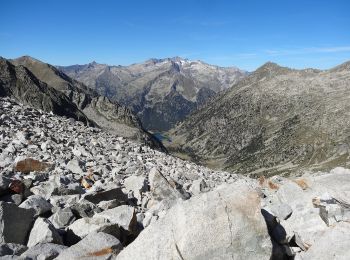
• Website: http://www.rutespirineus.cat/rutes/besiberri-nord-des-de-cavallers-per-riu-malo
![Trail On foot Lleida - Camí Natural del Riu. Ruta 2b - Photo](https://media.geolcdn.com/t/350/260/31f6dca0-4820-4466-9f44-93f1bd443cfe.jpeg&format=jpg&maxdim=2)
![On foot On foot](https://static1.geolcdn.com/sitytour/trail-icons/100.png)
Km
On foot
![](/images/other/stat-length.png)
![](https://static1.geolcdn.com/siteimages/upload/files/1508320355ic_sort_den_pos_24dp.png)
![](https://static1.geolcdn.com/siteimages/upload/files/1508320355ic_sort_den_neg_24dp.png)
![](https://static1.geolcdn.com/siteimages/upload/files/16400158638029165_repeat_loop_refresh_sync_direction_icon.png)
• Trail created by Ministerio de Agricultura, Pesca y Alimentación. Website: https://www.mapa.gob.es/es/desarrollo-r...
![Trail On foot Lleida - Camí Natural del Riu. Ruta 2a - Photo](https://media.geolcdn.com/t/350/260/eb70cd2d-57cd-42f8-9886-dc978a2489d7.jpeg&format=jpg&maxdim=2)
![On foot On foot](https://static1.geolcdn.com/sitytour/trail-icons/100.png)
Km
On foot
![](/images/other/stat-length.png)
![](https://static1.geolcdn.com/siteimages/upload/files/1508320355ic_sort_den_pos_24dp.png)
![](https://static1.geolcdn.com/siteimages/upload/files/1508320355ic_sort_den_neg_24dp.png)
![](https://static1.geolcdn.com/siteimages/upload/files/16400158638029165_repeat_loop_refresh_sync_direction_icon.png)
• Trail created by Ministerio de Agricultura, Pesca y Alimentación. Website: https://www.mapa.gob.es/es/desarrollo-r...
![Trail On foot Lleida - Camí Natural del Riu. Ruta 1 - Photo](https://media.geolcdn.com/t/350/260/6c703204-c21c-4695-884e-ecdb78c48fb9.jpeg&format=jpg&maxdim=2)
![On foot On foot](https://static1.geolcdn.com/sitytour/trail-icons/100.png)
Km
On foot
![](/images/other/stat-length.png)
![](https://static1.geolcdn.com/siteimages/upload/files/1508320355ic_sort_den_pos_24dp.png)
![](https://static1.geolcdn.com/siteimages/upload/files/1508320355ic_sort_den_neg_24dp.png)
![](https://static1.geolcdn.com/siteimages/upload/files/16400158638029165_repeat_loop_refresh_sync_direction_icon.png)
• Trail created by Ministerio de Agricultura, Pesca y Alimentación. Website: https://www.mapa.gob.es/es/desarrollo-r...
![Trail On foot Vielha e Mijaran - Camí Natural del Port de Vielha - Photo](https://media.geolcdn.com/t/350/260/f29889ef-9feb-497c-879e-45612782bed6.jpeg&format=jpg&maxdim=2)
![On foot On foot](https://static1.geolcdn.com/sitytour/trail-icons/100.png)
Km
On foot
![](/images/other/stat-length.png)
![](https://static1.geolcdn.com/siteimages/upload/files/1508320355ic_sort_den_pos_24dp.png)
![](https://static1.geolcdn.com/siteimages/upload/files/1508320355ic_sort_den_neg_24dp.png)
![](https://static1.geolcdn.com/siteimages/upload/files/16400158638029165_repeat_loop_refresh_sync_direction_icon.png)
• Trail created by Ministerio de Agricultura, Pesca y Alimentación. Website: https://www.mapa.gob.es/es/desarrollo-r...
![Trail On foot la Torre de Cabdella - El Carrilet d'Estany Gento - Photo](https://media.geolcdn.com/t/350/260/c5e5dbcd-c92e-4604-9adf-b58fc5491a1e.jpeg&format=jpg&maxdim=2)
![On foot On foot](https://static1.geolcdn.com/sitytour/trail-icons/100.png)
Km
On foot
![](/images/other/stat-length.png)
![](https://static1.geolcdn.com/siteimages/upload/files/1508320355ic_sort_den_pos_24dp.png)
![](https://static1.geolcdn.com/siteimages/upload/files/1508320355ic_sort_den_neg_24dp.png)
![](https://static1.geolcdn.com/siteimages/upload/files/16400158638029165_repeat_loop_refresh_sync_direction_icon.png)
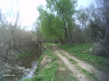
• Website: http://www.pallarsjussa.net/ca/que-fer/senderisme/el-carrilet-destany-gento
![Trail Walking Naut Aran - Cirque de colomers - Photo](https://media.geolcdn.com/t/350/260/ext.jpg?maxdim=2&url=https%3A%2F%2Fstatic1.geolcdn.com%2Fsiteimages%2Fupload%2Ffiles%2F1553511878bg_sport_marche.png)
![Walking Walking](https://static1.geolcdn.com/sitytour/trail-icons/101.png)
Km
Walking
![](/images/other/stat-length.png)
![](https://static1.geolcdn.com/siteimages/upload/files/1508320355ic_sort_den_pos_24dp.png)
![](https://static1.geolcdn.com/siteimages/upload/files/1508320355ic_sort_den_neg_24dp.png)
![](https://static1.geolcdn.com/siteimages/upload/files/16400158638029165_repeat_loop_refresh_sync_direction_icon.png)
• depuis le refuge de colomers cirque des lacs puis retour banhes de tredos
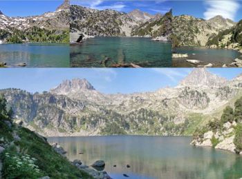
![Trail Walking Alt Àneu - lac de Gerber - Photo](https://media.geolcdn.com/t/350/260/ext.jpg?maxdim=2&url=https%3A%2F%2Fstatic1.geolcdn.com%2Fsiteimages%2Fupload%2Ffiles%2F1553511878bg_sport_marche.png)
![Walking Walking](https://static1.geolcdn.com/sitytour/trail-icons/101.png)
Km
Walking
![](/images/other/stat-length.png)
![](https://static1.geolcdn.com/siteimages/upload/files/1508320355ic_sort_den_pos_24dp.png)
![](https://static1.geolcdn.com/siteimages/upload/files/1508320355ic_sort_den_neg_24dp.png)
![](https://static1.geolcdn.com/siteimages/upload/files/16400158638029165_repeat_loop_refresh_sync_direction_icon.png)
• 2 lacs au dessus qui se mérite
![Trail Walking Espot - espotLacstmaurici - Photo](https://media.geolcdn.com/t/350/260/ext.jpg?maxdim=2&url=https%3A%2F%2Fstatic1.geolcdn.com%2Fsiteimages%2Fupload%2Ffiles%2F1553511878bg_sport_marche.png)
![Walking Walking](https://static1.geolcdn.com/sitytour/trail-icons/101.png)
Km
Walking
![](/images/other/stat-length.png)
![](https://static1.geolcdn.com/siteimages/upload/files/1508320355ic_sort_den_pos_24dp.png)
![](https://static1.geolcdn.com/siteimages/upload/files/1508320355ic_sort_den_neg_24dp.png)
![](https://static1.geolcdn.com/siteimages/upload/files/16400158638029165_repeat_loop_refresh_sync_direction_icon.png)
• au coeur des encantats
![Trail Walking Vielha e Mijaran - Boucle du Col des Aranais par le Trou du Toro - Photo](https://media.geolcdn.com/t/350/260/ext.jpg?maxdim=2&url=https%3A%2F%2Fservices.sitytrail.com%2FGeolivesWS%2FDownloadMedia.ashx%3FTrailID%3D471659%26Media%3De674941f-343b-4414-82ec-cab02a601634.jpg)
![Walking Walking](https://static1.geolcdn.com/sitytour/trail-icons/101.png)
Km
Walking
![](/images/other/stat-length.png)
![](https://static1.geolcdn.com/siteimages/upload/files/1508320355ic_sort_den_pos_24dp.png)
![](https://static1.geolcdn.com/siteimages/upload/files/1508320355ic_sort_den_neg_24dp.png)
![](https://static1.geolcdn.com/siteimages/upload/files/16400158638029165_repeat_loop_refresh_sync_direction_icon.png)
![Trail Walking Naut Aran - 2022-09-15 - plan de beret , lacs de bacivèr - Photo](https://media.geolcdn.com/t/350/260/e4950dc2-723c-4e94-98dc-39f945bd0abf.jpg&format=jpg&maxdim=2)
![Walking Walking](https://static1.geolcdn.com/sitytour/trail-icons/101.png)
Km
Walking
![](/images/other/stat-length.png)
![](https://static1.geolcdn.com/siteimages/upload/files/1508320355ic_sort_den_pos_24dp.png)
![](https://static1.geolcdn.com/siteimages/upload/files/1508320355ic_sort_den_neg_24dp.png)
![](https://static1.geolcdn.com/siteimages/upload/files/16400158638029165_repeat_loop_refresh_sync_direction_icon.png)
20 trails displayed on 325
FREE GPS app for hiking
Activities
Nearby regions
- Abella de la Conca
- Àger
- Aitona
- Alàs i Cerc
- Alfarràs
- Alins
- Almatret
- Alòs de Balaguer
- Alt Àneu
- Arres
- Arsèguel
- Artesa de Segre
- Baix Pallars
- Balaguer
- Bassella
- Bausen
- Bellcaire d'Urgell
- Bellpuig
- Bellver de Cerdanya
- Biosca
- Bossòst
- Cabó
- Camarasa
- Canejan
- Castell de Mur
- Castellnou de Seana
- Castelló de Farfanya
- Cava
- Cervera
- Clariana de Cardener
- Coll de Nargó
- Conca de Dalt
- Espot
- Estamariu
- Esterri d'Àneu
- Farrera
- Fígols i Alinyà
- Foradada
- Gósol
- Guimerà
- Guixers
- Isona i Conca Dellà
- Josa i Tuixén
- La Guingueta d'Àneu
- Les
- Lladorre
- Lladurs
- Llardecans
- Llavorsí
- Lleida
- Lles de Cerdanya
- Llimiana
- Mollerussa
- Montellà i Martinet
- Montferrer i Castellbò
- Montoliu de Segarra
- Naut Aran
- Navès
- Oliana
- Olius
- Organyà
- Os de Balaguer
- Peramola
- Pinós
- Prats i Sansor
- Prullans
- Rialp
- Ribera d'Urgellet
- Riner
- Riu de Cerdanya
- Sant Esteve de la Sarga
- Sant Llorenç de Morunys
- Sant Martí de Riucorb
- Sarroca de Bellera
- Sarroca de Lleida
- Senterada
- Seròs
- Solsona
- Soriguera
- Sort
- Talarn
- Tàrrega
- Tírvia
- Torà
- Torrebesses
- Torres de Segre
- Tremp
- Vall de Cardós
- Vielha e Mijaran
- Vila-sana
- Vilaller
- Vilamòs
- Vilanova de Meià
- el Palau d'Anglesola
- el Pont de Bar
- el Pont de Suert
- es Bòrdes
- l'Albi
- la Baronia de Rialb
- la Coma i la Pedra
- la Granja d'Escarp
- la Molsosa
- la Pobla de Cérvoles
- la Pobla de Segur
- la Seu d'Urgell
- la Torre de Cabdella
- la Vall de Boí
- la Vansa i Fórnols
- les Valls d'Aguilar
- les Valls de Valira