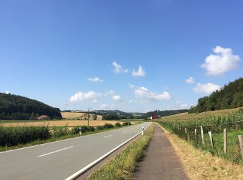
![](/images/other/stat-length.png)
- Trails
- Outdoor
- Germany
- Hesse
- Landkreis Waldeck-Frankenberg
- Bad Arolsen
Bad Arolsen, Landkreis Waldeck-Frankenberg: Best trails, routes and walks
Bad Arolsen: Discover the best trails: 55 hiking trails. All these trails, routes and outdoor activities are available in our SityTrail applications for smartphones and tablets.
The best trails (55)
![Trail On foot Bad Arolsen - Bonifatiuspfad Abschnitt 2, Bad Arolsen - Volkhardinghausen - Photo](https://media.geolcdn.com/t/350/260/e8f815d9-dbf6-42c3-98ea-630c3f7a7c4a.jpeg&format=jpg&maxdim=2)
![On foot On foot](https://static1.geolcdn.com/sitytour/trail-icons/100.png)
Km
On foot
![](/images/other/stat-length.png)
![](https://static1.geolcdn.com/siteimages/upload/files/1508320355ic_sort_den_pos_24dp.png)
![](https://static1.geolcdn.com/siteimages/upload/files/1508320355ic_sort_den_neg_24dp.png)
![](https://static1.geolcdn.com/siteimages/upload/files/16400158638029165_repeat_loop_refresh_sync_direction_icon.png)
• Trail created by Hessisch-Waldeckischer Gebirgs- und Heimatverein(HWGHV). Symbol: Weißer Buchstabe X, manchmal auf s...
![Trail On foot Bad Arolsen - Bonifatiuspfad Abschnitt 3, Volkhardinghausen - Naumburg - Photo](https://media.geolcdn.com/t/350/260/1aaced55-13f4-44d5-beeb-85f116f2e4a7.jpeg&format=jpg&maxdim=2)
![On foot On foot](https://static1.geolcdn.com/sitytour/trail-icons/100.png)
Km
On foot
![](/images/other/stat-length.png)
![](https://static1.geolcdn.com/siteimages/upload/files/1508320355ic_sort_den_pos_24dp.png)
![](https://static1.geolcdn.com/siteimages/upload/files/1508320355ic_sort_den_neg_24dp.png)
![](https://static1.geolcdn.com/siteimages/upload/files/16400158638029165_repeat_loop_refresh_sync_direction_icon.png)
• Trail created by Hessisch-Waldeckischer Gebirgs- und Heimatverein(HWGHV). Symbol: Weißer Buchstabe X, manchmal auf s...
![Trail On foot Bad Arolsen - Bad Arolsen Engelweg - Photo](https://media.geolcdn.com/t/350/260/c7c70984-951d-4824-a3f4-95c2632f47d9.jpeg&format=jpg&maxdim=2)
![On foot On foot](https://static1.geolcdn.com/sitytour/trail-icons/100.png)
Km
On foot
![](/images/other/stat-length.png)
![](https://static1.geolcdn.com/siteimages/upload/files/1508320355ic_sort_den_pos_24dp.png)
![](https://static1.geolcdn.com/siteimages/upload/files/1508320355ic_sort_den_neg_24dp.png)
![](https://static1.geolcdn.com/siteimages/upload/files/16400158638029165_repeat_loop_refresh_sync_direction_icon.png)
• Website: https://www.orte-verbinden.de/Wege/Engelweg/
![Trail On foot Bad Arolsen - Bad Arolsen Wanderweg W4 - Photo](https://media.geolcdn.com/t/350/260/edf35338-435c-43b9-96fc-ba7c4276a780.jpeg&format=jpg&maxdim=2)
![On foot On foot](https://static1.geolcdn.com/sitytour/trail-icons/100.png)
Km
On foot
![](/images/other/stat-length.png)
![](https://static1.geolcdn.com/siteimages/upload/files/1508320355ic_sort_den_pos_24dp.png)
![](https://static1.geolcdn.com/siteimages/upload/files/1508320355ic_sort_den_neg_24dp.png)
![](https://static1.geolcdn.com/siteimages/upload/files/16400158638029165_repeat_loop_refresh_sync_direction_icon.png)
• Symbol: gelb W4 auf blau
![Trail On foot Bad Arolsen - Bad Arolsen Wanderweg K1 - Photo](https://media.geolcdn.com/t/350/260/715ef017-d756-4f9b-858b-dafe8e234bdc.jpeg&format=jpg&maxdim=2)
![On foot On foot](https://static1.geolcdn.com/sitytour/trail-icons/100.png)
Km
On foot
![](/images/other/stat-length.png)
![](https://static1.geolcdn.com/siteimages/upload/files/1508320355ic_sort_den_pos_24dp.png)
![](https://static1.geolcdn.com/siteimages/upload/files/1508320355ic_sort_den_neg_24dp.png)
![](https://static1.geolcdn.com/siteimages/upload/files/16400158638029165_repeat_loop_refresh_sync_direction_icon.png)
• Symbol: gelb K1 auf blau
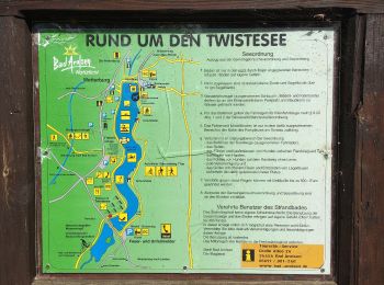
![Trail On foot Bad Arolsen - Bad Arolsen Wanderweg RUM - Photo](https://media.geolcdn.com/t/350/260/f7d17ff5-d119-4579-8ded-5e019ffc8b96.jpeg&format=jpg&maxdim=2)
![On foot On foot](https://static1.geolcdn.com/sitytour/trail-icons/100.png)
Km
On foot
![](/images/other/stat-length.png)
![](https://static1.geolcdn.com/siteimages/upload/files/1508320355ic_sort_den_pos_24dp.png)
![](https://static1.geolcdn.com/siteimages/upload/files/1508320355ic_sort_den_neg_24dp.png)
![](https://static1.geolcdn.com/siteimages/upload/files/16400158638029165_repeat_loop_refresh_sync_direction_icon.png)
• Symbol: gelb RUM auf blau
![Trail On foot Bad Arolsen - Bad Arolsen Wanderweg W2 - Photo](https://media.geolcdn.com/t/350/260/edf35338-435c-43b9-96fc-ba7c4276a780.jpeg&format=jpg&maxdim=2)
![On foot On foot](https://static1.geolcdn.com/sitytour/trail-icons/100.png)
Km
On foot
![](/images/other/stat-length.png)
![](https://static1.geolcdn.com/siteimages/upload/files/1508320355ic_sort_den_pos_24dp.png)
![](https://static1.geolcdn.com/siteimages/upload/files/1508320355ic_sort_den_neg_24dp.png)
![](https://static1.geolcdn.com/siteimages/upload/files/16400158638029165_repeat_loop_refresh_sync_direction_icon.png)
• Symbol: gelb W2 auf blau
![Trail On foot Bad Arolsen - Bad Arolsen Wanderweg W3 - Photo](https://media.geolcdn.com/t/350/260/edf35338-435c-43b9-96fc-ba7c4276a780.jpeg&format=jpg&maxdim=2)
![On foot On foot](https://static1.geolcdn.com/sitytour/trail-icons/100.png)
Km
On foot
![](/images/other/stat-length.png)
![](https://static1.geolcdn.com/siteimages/upload/files/1508320355ic_sort_den_pos_24dp.png)
![](https://static1.geolcdn.com/siteimages/upload/files/1508320355ic_sort_den_neg_24dp.png)
![](https://static1.geolcdn.com/siteimages/upload/files/16400158638029165_repeat_loop_refresh_sync_direction_icon.png)
• Symbol: gelb W3 auf blau
![Trail On foot Bad Arolsen - Bad Arolsen Wanderweg LB - Photo](https://media.geolcdn.com/t/350/260/676cab21-6ff1-4901-ba34-cd29badc0ca7.jpeg&format=jpg&maxdim=2)
![On foot On foot](https://static1.geolcdn.com/sitytour/trail-icons/100.png)
Km
On foot
![](/images/other/stat-length.png)
![](https://static1.geolcdn.com/siteimages/upload/files/1508320355ic_sort_den_pos_24dp.png)
![](https://static1.geolcdn.com/siteimages/upload/files/1508320355ic_sort_den_neg_24dp.png)
![](https://static1.geolcdn.com/siteimages/upload/files/16400158638029165_repeat_loop_refresh_sync_direction_icon.png)
• Symbol: gelb LB auf blau
![Trail On foot Bad Arolsen - Bad Arolsen Wanderweg B1 - Photo](https://media.geolcdn.com/t/350/260/56bd00ed-440b-4e47-bb2f-01367b687c56.jpeg&format=jpg&maxdim=2)
![On foot On foot](https://static1.geolcdn.com/sitytour/trail-icons/100.png)
Km
On foot
![](/images/other/stat-length.png)
![](https://static1.geolcdn.com/siteimages/upload/files/1508320355ic_sort_den_pos_24dp.png)
![](https://static1.geolcdn.com/siteimages/upload/files/1508320355ic_sort_den_neg_24dp.png)
![](https://static1.geolcdn.com/siteimages/upload/files/16400158638029165_repeat_loop_refresh_sync_direction_icon.png)
• Symbol: gelb B1 auf blau
![Trail On foot Bad Arolsen - Rundwanderweg Landau 1 - Photo](https://media.geolcdn.com/t/350/260/676cab21-6ff1-4901-ba34-cd29badc0ca7.jpeg&format=jpg&maxdim=2)
![On foot On foot](https://static1.geolcdn.com/sitytour/trail-icons/100.png)
Km
On foot
![](/images/other/stat-length.png)
![](https://static1.geolcdn.com/siteimages/upload/files/1508320355ic_sort_den_pos_24dp.png)
![](https://static1.geolcdn.com/siteimages/upload/files/1508320355ic_sort_den_neg_24dp.png)
![](https://static1.geolcdn.com/siteimages/upload/files/16400158638029165_repeat_loop_refresh_sync_direction_icon.png)
• Symbol: Gelbe Schrift L 1 auf blauem Hintergrund
![Trail On foot Bad Arolsen - Rundwanderweg Landau 9 - Photo](https://media.geolcdn.com/t/350/260/676cab21-6ff1-4901-ba34-cd29badc0ca7.jpeg&format=jpg&maxdim=2)
![On foot On foot](https://static1.geolcdn.com/sitytour/trail-icons/100.png)
Km
On foot
![](/images/other/stat-length.png)
![](https://static1.geolcdn.com/siteimages/upload/files/1508320355ic_sort_den_pos_24dp.png)
![](https://static1.geolcdn.com/siteimages/upload/files/1508320355ic_sort_den_neg_24dp.png)
![](https://static1.geolcdn.com/siteimages/upload/files/16400158638029165_repeat_loop_refresh_sync_direction_icon.png)
• Symbol: Gelbe Schrift L 9 auf blauem Hintergrund
![Trail On foot Bad Arolsen - Bad Arolsen Wanderweg A4 - Photo](https://media.geolcdn.com/t/350/260/d9924c14-52c7-495d-9e75-74ba99ef7a03.jpeg&format=jpg&maxdim=2)
![On foot On foot](https://static1.geolcdn.com/sitytour/trail-icons/100.png)
Km
On foot
![](/images/other/stat-length.png)
![](https://static1.geolcdn.com/siteimages/upload/files/1508320355ic_sort_den_pos_24dp.png)
![](https://static1.geolcdn.com/siteimages/upload/files/1508320355ic_sort_den_neg_24dp.png)
![](https://static1.geolcdn.com/siteimages/upload/files/16400158638029165_repeat_loop_refresh_sync_direction_icon.png)
• Symbol: gelb A4 auf blau
![Trail On foot Bad Arolsen - Rundwanderweg Landau 6 - Photo](https://media.geolcdn.com/t/350/260/676cab21-6ff1-4901-ba34-cd29badc0ca7.jpeg&format=jpg&maxdim=2)
![On foot On foot](https://static1.geolcdn.com/sitytour/trail-icons/100.png)
Km
On foot
![](/images/other/stat-length.png)
![](https://static1.geolcdn.com/siteimages/upload/files/1508320355ic_sort_den_pos_24dp.png)
![](https://static1.geolcdn.com/siteimages/upload/files/1508320355ic_sort_den_neg_24dp.png)
![](https://static1.geolcdn.com/siteimages/upload/files/16400158638029165_repeat_loop_refresh_sync_direction_icon.png)
• Symbol: Gelbe Schrift L 6 auf blauem Hintergrund
![Trail On foot Bad Arolsen - Rundwanderweg Landau 7 - Photo](https://media.geolcdn.com/t/350/260/676cab21-6ff1-4901-ba34-cd29badc0ca7.jpeg&format=jpg&maxdim=2)
![On foot On foot](https://static1.geolcdn.com/sitytour/trail-icons/100.png)
Km
On foot
![](/images/other/stat-length.png)
![](https://static1.geolcdn.com/siteimages/upload/files/1508320355ic_sort_den_pos_24dp.png)
![](https://static1.geolcdn.com/siteimages/upload/files/1508320355ic_sort_den_neg_24dp.png)
![](https://static1.geolcdn.com/siteimages/upload/files/16400158638029165_repeat_loop_refresh_sync_direction_icon.png)
• Symbol: Gelbe Schrift L 7 auf blauem Hintergrund
![Trail On foot Bad Arolsen - Rundwanderweg Landau 5 - Photo](https://media.geolcdn.com/t/350/260/676cab21-6ff1-4901-ba34-cd29badc0ca7.jpeg&format=jpg&maxdim=2)
![On foot On foot](https://static1.geolcdn.com/sitytour/trail-icons/100.png)
Km
On foot
![](/images/other/stat-length.png)
![](https://static1.geolcdn.com/siteimages/upload/files/1508320355ic_sort_den_pos_24dp.png)
![](https://static1.geolcdn.com/siteimages/upload/files/1508320355ic_sort_den_neg_24dp.png)
![](https://static1.geolcdn.com/siteimages/upload/files/16400158638029165_repeat_loop_refresh_sync_direction_icon.png)
• Symbol: Gelbe Schrift L 5 auf blauem Hintergrund
![Trail On foot Bad Arolsen - Rundwanderweg Landau 4 - Photo](https://media.geolcdn.com/t/350/260/676cab21-6ff1-4901-ba34-cd29badc0ca7.jpeg&format=jpg&maxdim=2)
![On foot On foot](https://static1.geolcdn.com/sitytour/trail-icons/100.png)
Km
On foot
![](/images/other/stat-length.png)
![](https://static1.geolcdn.com/siteimages/upload/files/1508320355ic_sort_den_pos_24dp.png)
![](https://static1.geolcdn.com/siteimages/upload/files/1508320355ic_sort_den_neg_24dp.png)
![](https://static1.geolcdn.com/siteimages/upload/files/16400158638029165_repeat_loop_refresh_sync_direction_icon.png)
• Symbol: Gelbe Schrift L 4 auf blauem Hintergrund
![Trail On foot Bad Arolsen - Rundwanderweg Landau 3 - Photo](https://media.geolcdn.com/t/350/260/676cab21-6ff1-4901-ba34-cd29badc0ca7.jpeg&format=jpg&maxdim=2)
![On foot On foot](https://static1.geolcdn.com/sitytour/trail-icons/100.png)
Km
On foot
![](/images/other/stat-length.png)
![](https://static1.geolcdn.com/siteimages/upload/files/1508320355ic_sort_den_pos_24dp.png)
![](https://static1.geolcdn.com/siteimages/upload/files/1508320355ic_sort_den_neg_24dp.png)
![](https://static1.geolcdn.com/siteimages/upload/files/16400158638029165_repeat_loop_refresh_sync_direction_icon.png)
• Symbol: Gelbe Schrift L 3 auf blauem Hintergrund
![Trail On foot Bad Arolsen - Bad Arolsen Wanderweg A2 - Photo](https://media.geolcdn.com/t/350/260/e8f815d9-dbf6-42c3-98ea-630c3f7a7c4a.jpeg&format=jpg&maxdim=2)
![On foot On foot](https://static1.geolcdn.com/sitytour/trail-icons/100.png)
Km
On foot
![](/images/other/stat-length.png)
![](https://static1.geolcdn.com/siteimages/upload/files/1508320355ic_sort_den_pos_24dp.png)
![](https://static1.geolcdn.com/siteimages/upload/files/1508320355ic_sort_den_neg_24dp.png)
![](https://static1.geolcdn.com/siteimages/upload/files/16400158638029165_repeat_loop_refresh_sync_direction_icon.png)
• Symbol: gelb A2 auf blau
![Trail On foot Bad Arolsen - Bad Arolsen Wanderweg H4 - Photo](https://media.geolcdn.com/t/350/260/4010d69b-3dbf-4d66-af48-5ad9aee614e0.jpeg&format=jpg&maxdim=2)
![On foot On foot](https://static1.geolcdn.com/sitytour/trail-icons/100.png)
Km
On foot
![](/images/other/stat-length.png)
![](https://static1.geolcdn.com/siteimages/upload/files/1508320355ic_sort_den_pos_24dp.png)
![](https://static1.geolcdn.com/siteimages/upload/files/1508320355ic_sort_den_neg_24dp.png)
![](https://static1.geolcdn.com/siteimages/upload/files/16400158638029165_repeat_loop_refresh_sync_direction_icon.png)
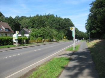
• Symbol: gelb H4 auf grün
20 trails displayed on 55
FREE GPS app for hiking