![](/images/other/stat-length.png)
- Trails
- Outdoor
- Switzerland
- Luzern
- Unknown
- Emmen
Emmen, Unknown: Best trails, routes and walks
Emmen: Discover the best trails: 8 hiking trails. All these trails, routes and outdoor activities are available in our SityTrail applications for smartphones and tablets.
The best trails (8)
![Trail On foot Emmen - Waldibrugg - Hirselen - Photo](https://media.geolcdn.com/t/350/260/fa8a2e0c-7da2-4445-8b60-04ee0c5b05ef.jpeg&format=jpg&maxdim=2)
![On foot On foot](https://static1.geolcdn.com/sitytour/trail-icons/100.png)
Km
On foot
![](/images/other/stat-length.png)
![](https://static1.geolcdn.com/siteimages/upload/files/1508320355ic_sort_den_pos_24dp.png)
![](https://static1.geolcdn.com/siteimages/upload/files/1508320355ic_sort_den_neg_24dp.png)
![](https://static1.geolcdn.com/siteimages/upload/files/16400158638029165_repeat_loop_refresh_sync_direction_icon.png)
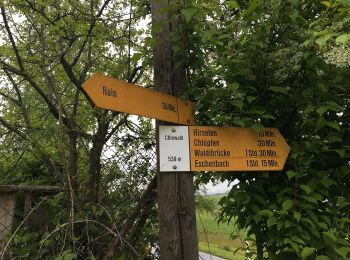
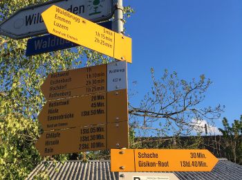
• Trail created by Luzerner Wanderwege. Waldibrugg - Hirselen Symbol: gelber Rhombus
![Trail On foot Emmen - Eschenbach - Waldibrugg - Photo](https://media.geolcdn.com/t/350/260/3ee7faf4-aece-4535-9ed3-2d668f57bfe7.jpeg&format=jpg&maxdim=2)
![On foot On foot](https://static1.geolcdn.com/sitytour/trail-icons/100.png)
Km
On foot
![](/images/other/stat-length.png)
![](https://static1.geolcdn.com/siteimages/upload/files/1508320355ic_sort_den_pos_24dp.png)
![](https://static1.geolcdn.com/siteimages/upload/files/1508320355ic_sort_den_neg_24dp.png)
![](https://static1.geolcdn.com/siteimages/upload/files/16400158638029165_repeat_loop_refresh_sync_direction_icon.png)
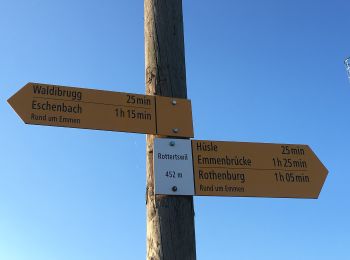
• Eschenbach - Waldibrugg Symbol: gelber Diamant
![Trail On foot Emmen - Eschenbach - Höndle - Waldibrugg - Photo](https://media.geolcdn.com/t/350/260/3ee7faf4-aece-4535-9ed3-2d668f57bfe7.jpeg&format=jpg&maxdim=2)
![On foot On foot](https://static1.geolcdn.com/sitytour/trail-icons/100.png)
Km
On foot
![](/images/other/stat-length.png)
![](https://static1.geolcdn.com/siteimages/upload/files/1508320355ic_sort_den_pos_24dp.png)
![](https://static1.geolcdn.com/siteimages/upload/files/1508320355ic_sort_den_neg_24dp.png)
![](https://static1.geolcdn.com/siteimages/upload/files/16400158638029165_repeat_loop_refresh_sync_direction_icon.png)
• Eschenbach - Höndle - Waldibrugg Symbol: gelber Diamant
![Trail On foot Emmen - Perlenbrücke - Rathausenbrücke - Photo](https://media.geolcdn.com/t/350/260/c1b2d98f-1a13-4272-ad2b-84a94c2b1f5b.jpeg&format=jpg&maxdim=2)
![On foot On foot](https://static1.geolcdn.com/sitytour/trail-icons/100.png)
Km
On foot
![](/images/other/stat-length.png)
![](https://static1.geolcdn.com/siteimages/upload/files/1508320355ic_sort_den_pos_24dp.png)
![](https://static1.geolcdn.com/siteimages/upload/files/1508320355ic_sort_den_neg_24dp.png)
![](https://static1.geolcdn.com/siteimages/upload/files/16400158638029165_repeat_loop_refresh_sync_direction_icon.png)
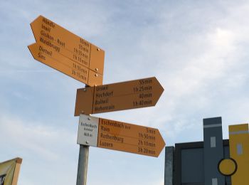
• Perlenbrücke - Rathausenbrücke Symbol: gelber Diamant
![Trail On foot Emmen - Emmenbrücke-Rotenburg - Photo](https://media.geolcdn.com/t/350/260/a47ec594-ce94-4200-b1b8-d01dcada7297.jpeg&format=jpg&maxdim=2)
![On foot On foot](https://static1.geolcdn.com/sitytour/trail-icons/100.png)
Km
On foot
![](/images/other/stat-length.png)
![](https://static1.geolcdn.com/siteimages/upload/files/1508320355ic_sort_den_pos_24dp.png)
![](https://static1.geolcdn.com/siteimages/upload/files/1508320355ic_sort_den_neg_24dp.png)
![](https://static1.geolcdn.com/siteimages/upload/files/16400158638029165_repeat_loop_refresh_sync_direction_icon.png)
• Trail created by Luzerner Wanderwege. Emmenbrücke-Rotenburg Symbol: gelber Rhombus
![Trail On foot Emmen - Moos - Rottertswil - Photo](https://media.geolcdn.com/t/350/260/d288af42-6c44-4f8d-8e3f-b374f7cb84a5.jpeg&format=jpg&maxdim=2)
![On foot On foot](https://static1.geolcdn.com/sitytour/trail-icons/100.png)
Km
On foot
![](/images/other/stat-length.png)
![](https://static1.geolcdn.com/siteimages/upload/files/1508320355ic_sort_den_pos_24dp.png)
![](https://static1.geolcdn.com/siteimages/upload/files/1508320355ic_sort_den_neg_24dp.png)
![](https://static1.geolcdn.com/siteimages/upload/files/16400158638029165_repeat_loop_refresh_sync_direction_icon.png)
• Trail created by Luzerner Wanderwege. Moos - Rottertswil Symbol: gelber Rhombus
![Trail On foot Emmen - Cholbe - Waldibrugg - Photo](https://media.geolcdn.com/t/350/260/b64a7078-807f-4c8d-bd06-9d18af054554.jpeg&format=jpg&maxdim=2)
![On foot On foot](https://static1.geolcdn.com/sitytour/trail-icons/100.png)
Km
On foot
![](/images/other/stat-length.png)
![](https://static1.geolcdn.com/siteimages/upload/files/1508320355ic_sort_den_pos_24dp.png)
![](https://static1.geolcdn.com/siteimages/upload/files/1508320355ic_sort_den_neg_24dp.png)
![](https://static1.geolcdn.com/siteimages/upload/files/16400158638029165_repeat_loop_refresh_sync_direction_icon.png)
• Trail created by Luzerner Wanderwege. Cholbe - Waldibrugg Symbol: gelber Rhombus
![Trail Walking Emmen - vvvttt0007 - Photo](https://media.geolcdn.com/t/350/260/ext.jpg?maxdim=2&url=https%3A%2F%2Fstatic1.geolcdn.com%2Fsiteimages%2Fupload%2Ffiles%2F1553511878bg_sport_marche.png)
![Walking Walking](https://static1.geolcdn.com/sitytour/trail-icons/101.png)
Km
Walking
![](/images/other/stat-length.png)
![](https://static1.geolcdn.com/siteimages/upload/files/1508320355ic_sort_den_pos_24dp.png)
![](https://static1.geolcdn.com/siteimages/upload/files/1508320355ic_sort_den_neg_24dp.png)
![](https://static1.geolcdn.com/siteimages/upload/files/16400158638029165_repeat_loop_refresh_sync_direction_icon.png)
•
8 trails displayed on 8
FREE GPS app for hiking