![](/images/other/stat-length.png)
- Trails
- Outdoor
- Switzerland
- Bern
- Bern-Mittelland administrative district
Bern-Mittelland administrative district, Bern: Best trails, routes and walks
Bern-Mittelland administrative district: Discover the best trails: 58 hiking trails and 2 bike and mountain-bike routes. All these trails, routes and outdoor activities are available in our SityTrail applications for smartphones and tablets.
The best trails (99)
![Trail On foot Walkringen - Walkringen-Nest - Photo](https://media.geolcdn.com/t/350/260/d0744293-585d-40cf-9764-13cad7d920fa.jpeg&format=jpg&maxdim=2)
![On foot On foot](https://static1.geolcdn.com/sitytour/trail-icons/100.png)
Km
On foot
![](/images/other/stat-length.png)
![](https://static1.geolcdn.com/siteimages/upload/files/1508320355ic_sort_den_pos_24dp.png)
![](https://static1.geolcdn.com/siteimages/upload/files/1508320355ic_sort_den_neg_24dp.png)
![](https://static1.geolcdn.com/siteimages/upload/files/16400158638029165_repeat_loop_refresh_sync_direction_icon.png)
• Trail created by Berner Wanderwege. Symbol: gelbe Raute
![Trail On foot Kirchlindach - Oberlindach - Münchenbuchsee - Photo](https://media.geolcdn.com/t/350/260/8371a712-97cd-4e0a-9e7c-6436354ecffb.jpeg&format=jpg&maxdim=2)
![On foot On foot](https://static1.geolcdn.com/sitytour/trail-icons/100.png)
Km
On foot
![](/images/other/stat-length.png)
![](https://static1.geolcdn.com/siteimages/upload/files/1508320355ic_sort_den_pos_24dp.png)
![](https://static1.geolcdn.com/siteimages/upload/files/1508320355ic_sort_den_neg_24dp.png)
![](https://static1.geolcdn.com/siteimages/upload/files/16400158638029165_repeat_loop_refresh_sync_direction_icon.png)
• Trail created by Berner Wanderwege. Symbol: gelber Rhombus
![Trail On foot Bolligen - Deisswil-Cholgrueb - Photo](https://media.geolcdn.com/t/350/260/ee1c1a72-b9b8-448b-ad3f-4dc69b5d0cfd.jpeg&format=jpg&maxdim=2)
![On foot On foot](https://static1.geolcdn.com/sitytour/trail-icons/100.png)
Km
On foot
![](/images/other/stat-length.png)
![](https://static1.geolcdn.com/siteimages/upload/files/1508320355ic_sort_den_pos_24dp.png)
![](https://static1.geolcdn.com/siteimages/upload/files/1508320355ic_sort_den_neg_24dp.png)
![](https://static1.geolcdn.com/siteimages/upload/files/16400158638029165_repeat_loop_refresh_sync_direction_icon.png)
• Trail created by Berner Wanderwege. Deisswil-Cholgrueb Symbol: gelber Diamant
![Trail On foot Mühleberg - Gümmenen - Spengelried - Photo](https://media.geolcdn.com/t/350/260/98c5fc8a-983d-4bec-b663-74a35fa63b19.jpeg&format=jpg&maxdim=2)
![On foot On foot](https://static1.geolcdn.com/sitytour/trail-icons/100.png)
Km
On foot
![](/images/other/stat-length.png)
![](https://static1.geolcdn.com/siteimages/upload/files/1508320355ic_sort_den_pos_24dp.png)
![](https://static1.geolcdn.com/siteimages/upload/files/1508320355ic_sort_den_neg_24dp.png)
![](https://static1.geolcdn.com/siteimages/upload/files/16400158638029165_repeat_loop_refresh_sync_direction_icon.png)
• Trail created by Berner Wanderwege. Symbol: gelber Diamant
![Trail On foot Münchenwiler - Münchenwiler - Galmacher - Photo](https://media.geolcdn.com/t/350/260/80d7b792-55a1-4f2a-a2aa-c578474f83e0.jpeg&format=jpg&maxdim=2)
![On foot On foot](https://static1.geolcdn.com/sitytour/trail-icons/100.png)
Km
On foot
![](/images/other/stat-length.png)
![](https://static1.geolcdn.com/siteimages/upload/files/1508320355ic_sort_den_pos_24dp.png)
![](https://static1.geolcdn.com/siteimages/upload/files/1508320355ic_sort_den_neg_24dp.png)
![](https://static1.geolcdn.com/siteimages/upload/files/16400158638029165_repeat_loop_refresh_sync_direction_icon.png)
• Symbol: gelber Diamant
![Trail On foot Guggisberg - Laubbach - Brönnti Egg - Photo](https://media.geolcdn.com/t/350/260/3864d0ea-46f2-4511-9276-17e909bc6d28.jpeg&format=jpg&maxdim=2)
![On foot On foot](https://static1.geolcdn.com/sitytour/trail-icons/100.png)
Km
On foot
![](/images/other/stat-length.png)
![](https://static1.geolcdn.com/siteimages/upload/files/1508320355ic_sort_den_pos_24dp.png)
![](https://static1.geolcdn.com/siteimages/upload/files/1508320355ic_sort_den_neg_24dp.png)
![](https://static1.geolcdn.com/siteimages/upload/files/16400158638029165_repeat_loop_refresh_sync_direction_icon.png)
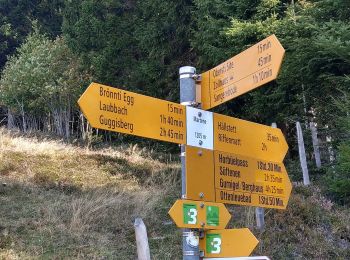
• Trail created by Berner Wanderwege. Laubbach - Brönnti Egg Symbol: gelber Diamant
![Trail On foot Guggisberg - Guggershorn - Laubbach - Photo](https://media.geolcdn.com/t/350/260/a8bc11d6-150e-494f-be8c-708e84680220.jpeg&format=jpg&maxdim=2)
![On foot On foot](https://static1.geolcdn.com/sitytour/trail-icons/100.png)
Km
On foot
![](/images/other/stat-length.png)
![](https://static1.geolcdn.com/siteimages/upload/files/1508320355ic_sort_den_pos_24dp.png)
![](https://static1.geolcdn.com/siteimages/upload/files/1508320355ic_sort_den_neg_24dp.png)
![](https://static1.geolcdn.com/siteimages/upload/files/16400158638029165_repeat_loop_refresh_sync_direction_icon.png)
• Trail created by Berner Wanderwege. Guggershorn - Laubbach Symbol: gelber Diamant
![Trail On foot Wohlen bei Bern - Illiswil - Wickacher - Photo](https://media.geolcdn.com/t/350/260/60a1bd14-b657-48fb-bd1f-2ef6d179fb2f.jpeg&format=jpg&maxdim=2)
![On foot On foot](https://static1.geolcdn.com/sitytour/trail-icons/100.png)
Km
On foot
![](/images/other/stat-length.png)
![](https://static1.geolcdn.com/siteimages/upload/files/1508320355ic_sort_den_pos_24dp.png)
![](https://static1.geolcdn.com/siteimages/upload/files/1508320355ic_sort_den_neg_24dp.png)
![](https://static1.geolcdn.com/siteimages/upload/files/16400158638029165_repeat_loop_refresh_sync_direction_icon.png)
• Trail created by Berner Wanderwege. Symbol: gelber Diamant
![Trail On foot Wohlen bei Bern - Illiswil - Weiermatt - Photo](https://media.geolcdn.com/t/350/260/17e0f03d-022a-4564-a90c-72ed4fe0e52d.jpeg&format=jpg&maxdim=2)
![On foot On foot](https://static1.geolcdn.com/sitytour/trail-icons/100.png)
Km
On foot
![](/images/other/stat-length.png)
![](https://static1.geolcdn.com/siteimages/upload/files/1508320355ic_sort_den_pos_24dp.png)
![](https://static1.geolcdn.com/siteimages/upload/files/1508320355ic_sort_den_neg_24dp.png)
![](https://static1.geolcdn.com/siteimages/upload/files/16400158638029165_repeat_loop_refresh_sync_direction_icon.png)
• Trail created by Berner Wanderwege. Symbol: gelber Diamant
![Trail On foot Wohlen bei Bern - Frieswil - Wickacher - Photo](https://media.geolcdn.com/t/350/260/60a1bd14-b657-48fb-bd1f-2ef6d179fb2f.jpeg&format=jpg&maxdim=2)
![On foot On foot](https://static1.geolcdn.com/sitytour/trail-icons/100.png)
Km
On foot
![](/images/other/stat-length.png)
![](https://static1.geolcdn.com/siteimages/upload/files/1508320355ic_sort_den_pos_24dp.png)
![](https://static1.geolcdn.com/siteimages/upload/files/1508320355ic_sort_den_neg_24dp.png)
![](https://static1.geolcdn.com/siteimages/upload/files/16400158638029165_repeat_loop_refresh_sync_direction_icon.png)
• Trail created by Berner Wanderwege. Symbol: gelber Diamant
![Trail On foot Frauenkappelen - Jaggisbachau - Wohlei - Photo](https://media.geolcdn.com/t/350/260/9fd7b831-850e-43f4-8c48-b554ac251ce8.jpeg&format=jpg&maxdim=2)
![On foot On foot](https://static1.geolcdn.com/sitytour/trail-icons/100.png)
Km
On foot
![](/images/other/stat-length.png)
![](https://static1.geolcdn.com/siteimages/upload/files/1508320355ic_sort_den_pos_24dp.png)
![](https://static1.geolcdn.com/siteimages/upload/files/1508320355ic_sort_den_neg_24dp.png)
![](https://static1.geolcdn.com/siteimages/upload/files/16400158638029165_repeat_loop_refresh_sync_direction_icon.png)
• Trail created by Berner Wanderwege. Symbol: gelber Diamant
![Trail On foot Mühleberg - Fuchsenried - Jaggisbachau - Photo](https://media.geolcdn.com/t/350/260/9fd7b831-850e-43f4-8c48-b554ac251ce8.jpeg&format=jpg&maxdim=2)
![On foot On foot](https://static1.geolcdn.com/sitytour/trail-icons/100.png)
Km
On foot
![](/images/other/stat-length.png)
![](https://static1.geolcdn.com/siteimages/upload/files/1508320355ic_sort_den_pos_24dp.png)
![](https://static1.geolcdn.com/siteimages/upload/files/1508320355ic_sort_den_neg_24dp.png)
![](https://static1.geolcdn.com/siteimages/upload/files/16400158638029165_repeat_loop_refresh_sync_direction_icon.png)
• Trail created by Berner Wanderwege. Symbol: gelber Diamant
![Trail On foot Toffen - Toffen - Belp - Photo](https://media.geolcdn.com/t/350/260/15b55688-b3f9-47dd-a7d6-3a44c58cd1dc.jpeg&format=jpg&maxdim=2)
![On foot On foot](https://static1.geolcdn.com/sitytour/trail-icons/100.png)
Km
On foot
![](/images/other/stat-length.png)
![](https://static1.geolcdn.com/siteimages/upload/files/1508320355ic_sort_den_pos_24dp.png)
![](https://static1.geolcdn.com/siteimages/upload/files/1508320355ic_sort_den_neg_24dp.png)
![](https://static1.geolcdn.com/siteimages/upload/files/16400158638029165_repeat_loop_refresh_sync_direction_icon.png)
• Trail created by Berner Wanderwege. Symbol: gelber Diamant
![Trail On foot Bern - CH-Karlsruhe - Bethlehem Tscharnergut - Photo](https://media.geolcdn.com/t/350/260/591946e0-4296-479e-a7e5-1e446bb93c69.jpeg&format=jpg&maxdim=2)
![On foot On foot](https://static1.geolcdn.com/sitytour/trail-icons/100.png)
Km
On foot
![](/images/other/stat-length.png)
![](https://static1.geolcdn.com/siteimages/upload/files/1508320355ic_sort_den_pos_24dp.png)
![](https://static1.geolcdn.com/siteimages/upload/files/1508320355ic_sort_den_neg_24dp.png)
![](https://static1.geolcdn.com/siteimages/upload/files/16400158638029165_repeat_loop_refresh_sync_direction_icon.png)
• Trail created by Berner Wanderwege. Karlsruhe - Bethlehem Tscharnergut Symbol: gelber Rhombus
![Trail On foot Ittigen - CH-Tiefenaubrücke - Felsenausteg - Photo](https://media.geolcdn.com/t/350/260/311a07e9-ff71-4f9a-9cdc-1fd03932c19d.jpeg&format=jpg&maxdim=2)
![On foot On foot](https://static1.geolcdn.com/sitytour/trail-icons/100.png)
Km
On foot
![](/images/other/stat-length.png)
![](https://static1.geolcdn.com/siteimages/upload/files/1508320355ic_sort_den_pos_24dp.png)
![](https://static1.geolcdn.com/siteimages/upload/files/1508320355ic_sort_den_neg_24dp.png)
![](https://static1.geolcdn.com/siteimages/upload/files/16400158638029165_repeat_loop_refresh_sync_direction_icon.png)
• Trail created by Berner Wanderwege. Tiefenaubrücke - Felsenausteg Symbol: gelber Rhombus
![Trail On foot Köniz - Mengestorf – Köniz - Photo](https://media.geolcdn.com/t/350/260/a8c9271f-4b41-4a9c-96ba-df20558f1579.jpeg&format=jpg&maxdim=2)
![On foot On foot](https://static1.geolcdn.com/sitytour/trail-icons/100.png)
Km
On foot
![](/images/other/stat-length.png)
![](https://static1.geolcdn.com/siteimages/upload/files/1508320355ic_sort_den_pos_24dp.png)
![](https://static1.geolcdn.com/siteimages/upload/files/1508320355ic_sort_den_neg_24dp.png)
![](https://static1.geolcdn.com/siteimages/upload/files/16400158638029165_repeat_loop_refresh_sync_direction_icon.png)
• Trail created by Berner Wanderwege. Symbol: gelber Diamant
![Trail On foot Urtenen-Schönbühl - CH-fixme - fixme - Photo](https://media.geolcdn.com/t/350/260/7ebe49cb-77a4-4f3f-b91e-4cf141fcdf26.jpeg&format=jpg&maxdim=2)
![On foot On foot](https://static1.geolcdn.com/sitytour/trail-icons/100.png)
Km
On foot
![](/images/other/stat-length.png)
![](https://static1.geolcdn.com/siteimages/upload/files/1508320355ic_sort_den_pos_24dp.png)
![](https://static1.geolcdn.com/siteimages/upload/files/1508320355ic_sort_den_neg_24dp.png)
![](https://static1.geolcdn.com/siteimages/upload/files/16400158638029165_repeat_loop_refresh_sync_direction_icon.png)
• fixme - fixme Symbol: gelber Diamant
![Trail On foot Meikirch - CH-Meikirch - Uettligen/Linde - Photo](https://media.geolcdn.com/t/350/260/6ec6840c-4a23-44d4-a9f7-cb8e4989b02e.jpeg&format=jpg&maxdim=2)
![On foot On foot](https://static1.geolcdn.com/sitytour/trail-icons/100.png)
Km
On foot
![](/images/other/stat-length.png)
![](https://static1.geolcdn.com/siteimages/upload/files/1508320355ic_sort_den_pos_24dp.png)
![](https://static1.geolcdn.com/siteimages/upload/files/1508320355ic_sort_den_neg_24dp.png)
![](https://static1.geolcdn.com/siteimages/upload/files/16400158638029165_repeat_loop_refresh_sync_direction_icon.png)
• Trail created by Berner Wanderwege. Meikirch - Uettligen/Linde Symbol: gelber Rhombus
![Trail On foot Wald (BE) - Englisberg - Hofmatt - Photo](https://media.geolcdn.com/t/350/260/fbb302ea-01ec-449e-b072-cce95446376d.jpeg&format=jpg&maxdim=2)
![On foot On foot](https://static1.geolcdn.com/sitytour/trail-icons/100.png)
Km
On foot
![](/images/other/stat-length.png)
![](https://static1.geolcdn.com/siteimages/upload/files/1508320355ic_sort_den_pos_24dp.png)
![](https://static1.geolcdn.com/siteimages/upload/files/1508320355ic_sort_den_neg_24dp.png)
![](https://static1.geolcdn.com/siteimages/upload/files/16400158638029165_repeat_loop_refresh_sync_direction_icon.png)
• Trail created by Berner Wanderwege. Symbol: gelber Diamant
![Trail On foot Wohlen bei Bern - Steinisweg - Wickacker - Photo](https://media.geolcdn.com/t/350/260/9fd7b831-850e-43f4-8c48-b554ac251ce8.jpeg&format=jpg&maxdim=2)
![On foot On foot](https://static1.geolcdn.com/sitytour/trail-icons/100.png)
Km
On foot
![](/images/other/stat-length.png)
![](https://static1.geolcdn.com/siteimages/upload/files/1508320355ic_sort_den_pos_24dp.png)
![](https://static1.geolcdn.com/siteimages/upload/files/1508320355ic_sort_den_neg_24dp.png)
![](https://static1.geolcdn.com/siteimages/upload/files/16400158638029165_repeat_loop_refresh_sync_direction_icon.png)
• Trail created by Berner Wanderwege. Symbol: gelber Diamant
20 trails displayed on 99
FREE GPS app for hiking
Activities
Nearby regions
- Belp
- Bern
- Bolligen
- Brenzikofen
- Fraubrunnen
- Frauenkappelen
- Gerzensee
- Guggisberg
- Herbligen
- Ittigen
- Jegenstorf
- Kehrsatz
- Kiesen
- Kirchdorf (BE)
- Kirchlindach
- Köniz
- Konolfingen
- Laupen
- Meikirch
- Mühleberg
- Münchenbuchsee
- Münchenwiler
- Münsingen
- Neuenegg
- Niedermuhlern
- Riggisberg
- Rubigen
- Rüeggisberg
- Rüschegg
- Schwarzenburg
- Thurnen
- Toffen
- Urtenen-Schönbühl
- Vechigen
- Wald (BE)
- Walkringen
- Wichtrach
- Wohlen bei Bern
- Worb
- Zäziwil
- Zollikofen