


19.3 km | 32 km-effort
Conthey: Discover the best trails: 40 hiking trails and 5 bike and mountain-bike routes. All these trails, routes and outdoor activities are available in our SityTrail applications for smartphones and tablets.
Walking


• Randonnée au lac Cleuson jusqu'à la cabane St Laurent en partant de la station de ski de Siviez. Je comptais monter ...

Walking
•
On foot
• Symbol: gelber Diamant (waagrecht)
 8.56
8.56
sport

On foot
On foot
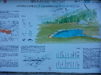
• Bisse de Tsandra
 15.183
sport
 16.563
sport
 15.109
sport
Walking

Other activity
•
Walking
•
Walking
•
Walking
•

Mountain bike
Walking
•
Walking
• Cette balade didactique d'environ 3h30 et destinée aux bons marcheurs vous emmène à la découverte de sites d'exceptio...
Nordic walking

Walking
Walking
20 trails displayed on 75
FREE GPS app for hiking
 SityTrail
IGN / Geographical institutes
SityTrail World
The world is yours!