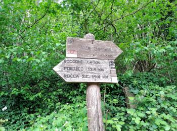
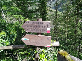
![](/images/other/stat-length.png)
- Trails
- On foot
- Italy
- Emilia-Romagna
- Forlì-Cesena
- Portico e San Benedetto
Portico e San Benedetto, Forlì-Cesena, On foot: Best trails, routes and walks
Portico e San Benedetto: Discover the best trails: 13 on foot. All these trails, routes and outdoor activities are available in our SityTrail applications for smartphones and tablets.
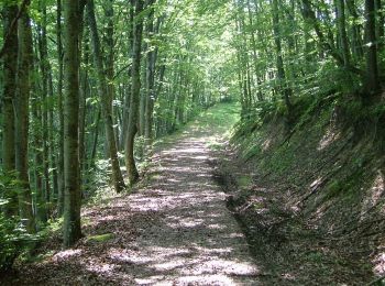
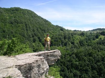
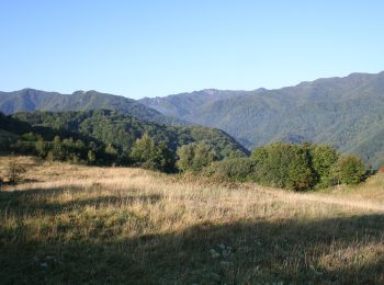
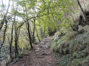
The best trails (13)
![Trail On foot Portico e San Benedetto - Un grande anello sopra a Castel dell’Alpe - Photo](https://media.geolcdn.com/t/350/260/0fa289ca-7c51-4ac9-85e8-89b1f300995c.jpeg&format=jpg&maxdim=2)
![On foot On foot](https://static1.geolcdn.com/sitytour/trail-icons/100.png)
Km
On foot
![](/images/other/stat-length.png)
![](https://static1.geolcdn.com/siteimages/upload/files/1508320355ic_sort_den_pos_24dp.png)
![](https://static1.geolcdn.com/siteimages/upload/files/1508320355ic_sort_den_neg_24dp.png)
![](https://static1.geolcdn.com/siteimages/upload/files/16400158638029165_repeat_loop_refresh_sync_direction_icon.png)
• Trail created by Parco Nazionale Foreste Casentinesi.
![Trail On foot Portico e San Benedetto - Da Bocconi verso i Monti Gemelli - Photo](https://media.geolcdn.com/t/350/260/c40944b8-5279-493d-97d9-4cd00eba42c5.jpeg&format=jpg&maxdim=2)
![On foot On foot](https://static1.geolcdn.com/sitytour/trail-icons/100.png)
Km
On foot
![](/images/other/stat-length.png)
![](https://static1.geolcdn.com/siteimages/upload/files/1508320355ic_sort_den_pos_24dp.png)
![](https://static1.geolcdn.com/siteimages/upload/files/1508320355ic_sort_den_neg_24dp.png)
![](https://static1.geolcdn.com/siteimages/upload/files/16400158638029165_repeat_loop_refresh_sync_direction_icon.png)
• Trail created by Parco Nazionale Foreste Casentinesi.
![Trail On foot Portico e San Benedetto - L’anello classico dell’Acquacheta - Photo](https://media.geolcdn.com/t/350/260/e0e65af1-b08c-4714-9518-f040c77653ce.jpeg&format=jpg&maxdim=2)
![On foot On foot](https://static1.geolcdn.com/sitytour/trail-icons/100.png)
Km
On foot
![](/images/other/stat-length.png)
![](https://static1.geolcdn.com/siteimages/upload/files/1508320355ic_sort_den_pos_24dp.png)
![](https://static1.geolcdn.com/siteimages/upload/files/1508320355ic_sort_den_neg_24dp.png)
![](https://static1.geolcdn.com/siteimages/upload/files/16400158638029165_repeat_loop_refresh_sync_direction_icon.png)
• Trail created by Parco Nazionale Foreste Casentinesi.
![Trail On foot Portico e San Benedetto - Tra i giganti della Val Tramazzo - Photo](https://media.geolcdn.com/t/350/260/ff2fdc6b-7a3c-4e1d-8ca2-846b130f5ad3.jpeg&format=jpg&maxdim=2)
![On foot On foot](https://static1.geolcdn.com/sitytour/trail-icons/100.png)
Km
On foot
![](/images/other/stat-length.png)
![](https://static1.geolcdn.com/siteimages/upload/files/1508320355ic_sort_den_pos_24dp.png)
![](https://static1.geolcdn.com/siteimages/upload/files/1508320355ic_sort_den_neg_24dp.png)
![](https://static1.geolcdn.com/siteimages/upload/files/16400158638029165_repeat_loop_refresh_sync_direction_icon.png)
• Trail created by Parco Nazional Foreste Casentinesi.
![Trail On foot Portico e San Benedetto - Valli selvagge tra Rabbi e Montone - Photo](https://media.geolcdn.com/t/350/260/53c89d03-85e0-435e-890b-ef4151cd30e6.jpeg&format=jpg&maxdim=2)
![On foot On foot](https://static1.geolcdn.com/sitytour/trail-icons/100.png)
Km
On foot
![](/images/other/stat-length.png)
![](https://static1.geolcdn.com/siteimages/upload/files/1508320355ic_sort_den_pos_24dp.png)
![](https://static1.geolcdn.com/siteimages/upload/files/1508320355ic_sort_den_neg_24dp.png)
![](https://static1.geolcdn.com/siteimages/upload/files/16400158638029165_repeat_loop_refresh_sync_direction_icon.png)
• Trail created by Parco Nazionale Foreste Casentinesi.
![Trail On foot Portico e San Benedetto - IT-427 - Photo](https://media.geolcdn.com/t/350/260/c8ebfc66-ef46-49ea-beb1-6eb8f9fabe57.jpeg&format=jpg&maxdim=2)
![On foot On foot](https://static1.geolcdn.com/sitytour/trail-icons/100.png)
Km
On foot
![](/images/other/stat-length.png)
![](https://static1.geolcdn.com/siteimages/upload/files/1508320355ic_sort_den_pos_24dp.png)
![](https://static1.geolcdn.com/siteimages/upload/files/1508320355ic_sort_den_neg_24dp.png)
![](https://static1.geolcdn.com/siteimages/upload/files/16400158638029165_repeat_loop_refresh_sync_direction_icon.png)
• Trail created by CAI Forlì.
![Trail On foot Portico e San Benedetto - IT-555 - Photo](https://media.geolcdn.com/t/350/260/a2d8eaba-d795-4e7f-9a08-00b864a5c67a.jpeg&format=jpg&maxdim=2)
![On foot On foot](https://static1.geolcdn.com/sitytour/trail-icons/100.png)
Km
On foot
![](/images/other/stat-length.png)
![](https://static1.geolcdn.com/siteimages/upload/files/1508320355ic_sort_den_pos_24dp.png)
![](https://static1.geolcdn.com/siteimages/upload/files/1508320355ic_sort_den_neg_24dp.png)
![](https://static1.geolcdn.com/siteimages/upload/files/16400158638029165_repeat_loop_refresh_sync_direction_icon.png)
• Trail created by CAI Faenza. Relation maintened by Gabriele Sani (CAI-FA) Symbol: 555 on white red flag Website: ...
![Trail On foot Portico e San Benedetto - IT-415 - Photo](https://media.geolcdn.com/t/350/260/169cf22e-c170-47d5-9810-a3b3e9f00be6.jpeg&format=jpg&maxdim=2)
![On foot On foot](https://static1.geolcdn.com/sitytour/trail-icons/100.png)
Km
On foot
![](/images/other/stat-length.png)
![](https://static1.geolcdn.com/siteimages/upload/files/1508320355ic_sort_den_pos_24dp.png)
![](https://static1.geolcdn.com/siteimages/upload/files/1508320355ic_sort_den_neg_24dp.png)
![](https://static1.geolcdn.com/siteimages/upload/files/16400158638029165_repeat_loop_refresh_sync_direction_icon.png)
• Trail created by CAI Faenza. Relation maintened by Gabriele Sani (CAI-FA) Symbol: 415 on white red flag Website: ...
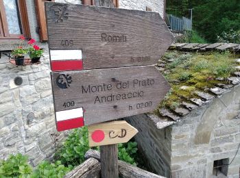
![Trail On foot Portico e San Benedetto - IT-409 - Photo](https://media.geolcdn.com/t/350/260/45c4a30a-c4d1-4abf-98f8-aeea26968641.jpeg&format=jpg&maxdim=2)
![On foot On foot](https://static1.geolcdn.com/sitytour/trail-icons/100.png)
Km
On foot
![](/images/other/stat-length.png)
![](https://static1.geolcdn.com/siteimages/upload/files/1508320355ic_sort_den_pos_24dp.png)
![](https://static1.geolcdn.com/siteimages/upload/files/1508320355ic_sort_den_neg_24dp.png)
![](https://static1.geolcdn.com/siteimages/upload/files/16400158638029165_repeat_loop_refresh_sync_direction_icon.png)
• Trail created by CAI Faenza. Relation maintened by Gabriele Sani (CAI-FA) Symbol: 409 on white red flag Website: ...
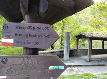
![Trail On foot Portico e San Benedetto - IT-407 - Photo](https://media.geolcdn.com/t/350/260/bcb07aeb-b523-4151-9c56-90a2a9f78e50.jpeg&format=jpg&maxdim=2)
![On foot On foot](https://static1.geolcdn.com/sitytour/trail-icons/100.png)
Km
On foot
![](/images/other/stat-length.png)
![](https://static1.geolcdn.com/siteimages/upload/files/1508320355ic_sort_den_pos_24dp.png)
![](https://static1.geolcdn.com/siteimages/upload/files/1508320355ic_sort_den_neg_24dp.png)
![](https://static1.geolcdn.com/siteimages/upload/files/16400158638029165_repeat_loop_refresh_sync_direction_icon.png)
• Trail created by CAI Faenza. Relation mantained by Gabriele Sani (CAI-FA) Symbol: 407 on white red flag Website: ...
![Trail On foot Portico e San Benedetto - Alta Via dei Parchi: Tappa 19 - Photo](https://media.geolcdn.com/t/350/260/c8ebfc66-ef46-49ea-beb1-6eb8f9fabe57.jpeg&format=jpg&maxdim=2)
![On foot On foot](https://static1.geolcdn.com/sitytour/trail-icons/100.png)
Km
On foot
![](/images/other/stat-length.png)
![](https://static1.geolcdn.com/siteimages/upload/files/1508320355ic_sort_den_pos_24dp.png)
![](https://static1.geolcdn.com/siteimages/upload/files/1508320355ic_sort_den_neg_24dp.png)
![](https://static1.geolcdn.com/siteimages/upload/files/16400158638029165_repeat_loop_refresh_sync_direction_icon.png)
![Trail On foot Portico e San Benedetto - IT-423 - Photo](https://media.geolcdn.com/t/350/260/53c89d03-85e0-435e-890b-ef4151cd30e6.jpeg&format=jpg&maxdim=2)
![On foot On foot](https://static1.geolcdn.com/sitytour/trail-icons/100.png)
Km
On foot
![](/images/other/stat-length.png)
![](https://static1.geolcdn.com/siteimages/upload/files/1508320355ic_sort_den_pos_24dp.png)
![](https://static1.geolcdn.com/siteimages/upload/files/1508320355ic_sort_den_neg_24dp.png)
![](https://static1.geolcdn.com/siteimages/upload/files/16400158638029165_repeat_loop_refresh_sync_direction_icon.png)
• Trail created by CAI Forlì. Symbol: 423 on white red flag Website: http://www.caiforli.it/
![Trail On foot Portico e San Benedetto - IT-323 - Photo](https://media.geolcdn.com/t/350/260/ext.jpg?maxdim=2&url=https%3A%2F%2Fstatic1.geolcdn.com%2Fsiteimages%2Fupload%2Ffiles%2F1545311037marcheuse_200dpi.jpg)
![On foot On foot](https://static1.geolcdn.com/sitytour/trail-icons/100.png)
Km
On foot
![](/images/other/stat-length.png)
![](https://static1.geolcdn.com/siteimages/upload/files/1508320355ic_sort_den_pos_24dp.png)
![](https://static1.geolcdn.com/siteimages/upload/files/1508320355ic_sort_den_neg_24dp.png)
![](https://static1.geolcdn.com/siteimages/upload/files/16400158638029165_repeat_loop_refresh_sync_direction_icon.png)
• Trail created by CAI Forlì. Symbol: 323 on white red flag Website: http://www.caiforli.it/
13 trails displayed on 13
FREE GPS app for hiking