![](/images/other/stat-length.png)
Bohars, Finistère, On foot: Best trails, routes and walks
1 comments
Bohars: Discover the best trails: 4 walking. All these trails, routes and outdoor activities are available in our SityTrail applications for smartphones and tablets.
The best trails (4)
![Trail Walking Bohars - Tour entre Penfeld et Tridour - Photo](https://media.geolcdn.com/t/350/260/ext.jpg?maxdim=2&url=https%3A%2F%2Fservices.sitytrail.com%2FGeolivesWS%2FDownloadMedia.ashx%3FTrailID%3D937402%26Media%3Dfix__20180405202600.jpg)
![Walking Walking](https://static1.geolcdn.com/sitytour/trail-icons/101.png)
Km
#1 - Tour entre Penfeld et Tridour
Walking
Easy
Bohars,
Brittany,
Finistère,
France
![](/images/other/stat-length.png)
8.4 km | 9.9 km-effort
2h 11min
![](https://static1.geolcdn.com/siteimages/upload/files/1508320355ic_sort_den_pos_24dp.png)
116 m
![](https://static1.geolcdn.com/siteimages/upload/files/1508320355ic_sort_den_neg_24dp.png)
117 m
![](https://static1.geolcdn.com/siteimages/upload/files/16400158638029165_repeat_loop_refresh_sync_direction_icon.png)
Yes
Balades en Finistère
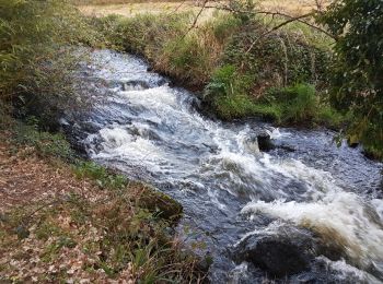
• Au départ du coté nord du par des Rives de Penfeld, on remonte le petit ruisseau du Tridour que l'on quitte pour rejo...
![Trail Walking Bohars - Bohars - Photo](https://media.geolcdn.com/t/350/260/ext.jpg?maxdim=2&url=https%3A%2F%2Fservices.sitytrail.com%2FGeolivesWS%2FDownloadMedia.ashx%3FTrailID%3D109380%26Media%3D3704_1.jpg)
![Walking Walking](https://static1.geolcdn.com/sitytour/trail-icons/101.png)
Km
#2 - Bohars
Walking
Medium
Bohars,
Brittany,
Finistère,
France
![](/images/other/stat-length.png)
9.7 km | 11.6 km-effort
1h 49min
![](https://static1.geolcdn.com/siteimages/upload/files/1508320355ic_sort_den_pos_24dp.png)
140 m
![](https://static1.geolcdn.com/siteimages/upload/files/1508320355ic_sort_den_neg_24dp.png)
140 m
![](https://static1.geolcdn.com/siteimages/upload/files/16400158638029165_repeat_loop_refresh_sync_direction_icon.png)
Yes
tracegps
![Trail Walking Bohars - BOHARS - Le Tromeur et la Brasserie - Photo](https://media.geolcdn.com/t/350/260/ext.jpg?maxdim=2&url=https%3A%2F%2Fstatic1.geolcdn.com%2Fsiteimages%2Fupload%2Ffiles%2F1553511878bg_sport_marche.png)
![Walking Walking](https://static1.geolcdn.com/sitytour/trail-icons/101.png)
Km
#3 - BOHARS - Le Tromeur et la Brasserie
Walking
Easy
Bohars,
Brittany,
Finistère,
France
![](/images/other/stat-length.png)
11.4 km | 13.5 km-effort
2h 55min
![](https://static1.geolcdn.com/siteimages/upload/files/1508320355ic_sort_den_pos_24dp.png)
155 m
![](https://static1.geolcdn.com/siteimages/upload/files/1508320355ic_sort_den_neg_24dp.png)
159 m
![](https://static1.geolcdn.com/siteimages/upload/files/16400158638029165_repeat_loop_refresh_sync_direction_icon.png)
Yes
mauricemear
![Trail Walking Bohars - BOHARS - Photo](https://media.geolcdn.com/t/350/260/ext.jpg?maxdim=2&url=https%3A%2F%2Fstatic1.geolcdn.com%2Fsiteimages%2Fupload%2Ffiles%2F1553511878bg_sport_marche.png)
![Walking Walking](https://static1.geolcdn.com/sitytour/trail-icons/101.png)
Km
#4 - BOHARS
Walking
Medium
Bohars,
Brittany,
Finistère,
France
![](/images/other/stat-length.png)
8.1 km | 9.8 km-effort
2h 14min
![](https://static1.geolcdn.com/siteimages/upload/files/1508320355ic_sort_den_pos_24dp.png)
126 m
![](https://static1.geolcdn.com/siteimages/upload/files/1508320355ic_sort_den_neg_24dp.png)
126 m
![](https://static1.geolcdn.com/siteimages/upload/files/16400158638029165_repeat_loop_refresh_sync_direction_icon.png)
Yes
mauricemear
4 trails displayed on 4
FREE GPS app for hiking