Laye, Hautes-Alpes, On foot: Best trails, routes and walks

2 comments

Laye: Discover the best trails: 1 on foot and 17 walking. All these trails, routes and outdoor activities are available in our SityTrail applications for smartphones and tablets.


The best trails (18)

Trail Walking Laye - Sentier de la Cuque prolongé - Photo
Walking 11.763
Km

Walking

Very easy
(1)
Laye, Provence-Alpes-Côte d'Azur, Hautes-Alpes, France
11.8 km | 19.7 km-effort
2h 24min
596 m
599 m
Yes
frederique.marti@laposte.net

Trail Walking Laye - les Sagnes du Plateau de Bayard. (20-01-19)A prox - Photo
Walking 9.283
Km

Walking

Easy
Laye, Provence-Alpes-Côte d'Azur, Hautes-Alpes, France
9.3 km | 12.2 km-effort
1h 47min
220 m
220 m
Yes
Dervalmarc

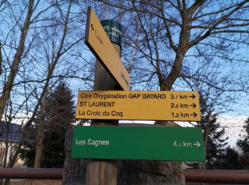
• A proximité du plateau de Bayard on trouve des marais naturels appelés Sagnes en patois local. Ce milieu présente une...

Trail Walking Laye - grande cuque 1018 - Photo
Walking 7.404
Km

Walking

Easy
Laye, Provence-Alpes-Côte d'Azur, Hautes-Alpes, France
7.4 km | 13 km-effort
5h 14min
419 m
420 m
Yes
goizet

Trail Walking Laye - Laye - Coste Belle - Photo
Walking 9.195
Km

Walking

Difficult
Laye, Provence-Alpes-Côte d'Azur, Hautes-Alpes, France
9.2 km | 18.4 km-effort
3h 50min
691 m
690 m
Yes
frizou83

Trail Walking Laye - la Cuque bois vert - Photo
Walking 11.846
Km

Walking

Very easy
Laye, Provence-Alpes-Côte d'Azur, Hautes-Alpes, France
11.8 km | 19.5 km-effort
2h 45min
570 m
574 m
Yes
frederique.marti@laposte.net

Trail Walking Laye - Laye - Variante Sagnassou - Photo
Walking 4.727
Km

Walking

Medium
Laye, Provence-Alpes-Côte d'Azur, Hautes-Alpes, France
4.7 km | 7.2 km-effort
1h 38min
186 m
186 m
Yes
frizou83

Trail Walking Laye - Laye - Boucle par le col Bayard - Photo
Walking 9.674
Km

Walking

Medium
Laye, Provence-Alpes-Côte d'Azur, Hautes-Alpes, France
9.7 km | 13.7 km-effort
3h 7min
305 m
305 m
Yes
frizou83

Trail Walking Laye - station de laye / les farelles  - Photo
Walking 6.478
Km

Walking

Easy
Laye, Provence-Alpes-Côte d'Azur, Hautes-Alpes, France
6.5 km | 9.4 km-effort
1h 49min
218 m
237 m
Yes
Bonet

Trail Walking Laye - Gap station de laye - Photo
Walking 15.268
Km

Walking

Very difficult
Laye, Provence-Alpes-Côte d'Azur, Hautes-Alpes, France
15.3 km | 25 km-effort
6h 20min
733 m
732 m
Yes
gerardfed

Trail Walking Laye - Laye - Col de Gleize - Photo
Walking 11.393
Km

Walking

Difficult
Laye, Provence-Alpes-Côte d'Azur, Hautes-Alpes, France
11.4 km | 18.6 km-effort
4h 14min
544 m
544 m
Yes
frizou83

Trail Walking Laye - Laye - Petite boucle du Clot de la Dame - Photo
Walking 4.167
Km

Walking

Very easy
Laye, Provence-Alpes-Côte d'Azur, Hautes-Alpes, France
4.2 km | 6.2 km-effort
1h 0min
154 m
154 m
Yes
frizou83

Trail Walking Laye - Laye - vers le Lauzon - Photo
Walking 8.403
Km

Walking

Difficult
Laye, Provence-Alpes-Côte d'Azur, Hautes-Alpes, France
8.4 km | 14.7 km-effort
3h 20min
475 m
475 m
Yes
frizou83

Trail Walking Laye - Notre-Dame de Bois-Vert (facile) - Photo
Walking 9.185
Km

Walking

Medium
Laye, Provence-Alpes-Côte d'Azur, Hautes-Alpes, France
9.2 km | 14.7 km-effort
3h 20min
416 m
417 m
Yes
frizou83

Trail Walking Laye - Ballade aoutour de Laye par les Farelles - Photo
Walking 6.436
Km

Walking

Medium
Laye, Provence-Alpes-Côte d'Azur, Hautes-Alpes, France
6.4 km | 10.6 km-effort
2h 24min
313 m
317 m
Yes
frizou83

Trail Walking Laye - Laye - Costebelle - Photo
Walking 11.858
Km

Walking

Very difficult
Laye, Provence-Alpes-Côte d'Azur, Hautes-Alpes, France
11.9 km | 23 km-effort
5h 9min
812 m
818 m
Yes
frizou83

Trail Walking Laye - laye 1 - Photo
Walking 5.777
Km

Walking

Easy
Laye, Provence-Alpes-Côte d'Azur, Hautes-Alpes, France
5.8 km | 8.7 km-effort
1h 24min
222 m
222 m
Yes
frizou83

Trail On foot Laye - depart station  de laye ; rocher du  midi  - Photo
On foot 16.989
Km

On foot

Difficult
Laye, Provence-Alpes-Côte d'Azur, Hautes-Alpes, France
17 km | 30 km-effort
Unknown
992 m
991 m
Yes
gerardmicheline

Trail Walking Laye - Laye - Pic de Gleize - Photo
Walking 13.185
Km

Walking

Difficult
Laye, Provence-Alpes-Côte d'Azur, Hautes-Alpes, France
13.2 km | 25 km-effort
5h 13min
868 m
868 m
Yes
frizou83

18 trails displayed on 18

FREE GPS app for hiking

Logo SityTrail SityTrail

IGN / Geographical institutes

Download SityTrail from the App Store Download SityTrail from Google Play

Logo SityTrail SityTrail World

The world is yours!

Download SityTrail from the App Store Download SityTrail from Google Play Download SityTrail on Huawei AppGallery

Activities

Close
My subscriptions