![](/images/other/stat-length.png)
Schwalm-Eder-Kreis, Hesse, On foot: Best trails, routes and walks
Schwalm-Eder-Kreis: Discover the best trails: 108 on foot. All these trails, routes and outdoor activities are available in our SityTrail applications for smartphones and tablets.
The best trails (108)
![Trail On foot Fritzlar - Bonifatiuspfad Abschnitt 5, Fritzlar - Borken - Photo](https://media.geolcdn.com/t/350/260/78688dab-9208-424d-b6ee-0314ea2134c2.jpeg&format=jpg&maxdim=2)
![On foot On foot](https://static1.geolcdn.com/sitytour/trail-icons/100.png)
Km
On foot
![](/images/other/stat-length.png)
![](https://static1.geolcdn.com/siteimages/upload/files/1508320355ic_sort_den_pos_24dp.png)
![](https://static1.geolcdn.com/siteimages/upload/files/1508320355ic_sort_den_neg_24dp.png)
![](https://static1.geolcdn.com/siteimages/upload/files/16400158638029165_repeat_loop_refresh_sync_direction_icon.png)
• Trail created by Hessisch-Waldeckischer Gebirgs- und Heimatverein(HWGHV). Symbol: Weißer Buchstabe X, manchmal auf s...
![Trail On foot Borken - Bonifatiuspfad Abschnitt 6, Borken - Frielendorf - Photo](https://media.geolcdn.com/t/350/260/2ce2e3f0-8ee0-4fed-9c5a-bcf66ddd952b.jpeg&format=jpg&maxdim=2)
![On foot On foot](https://static1.geolcdn.com/sitytour/trail-icons/100.png)
Km
On foot
![](/images/other/stat-length.png)
![](https://static1.geolcdn.com/siteimages/upload/files/1508320355ic_sort_den_pos_24dp.png)
![](https://static1.geolcdn.com/siteimages/upload/files/1508320355ic_sort_den_neg_24dp.png)
![](https://static1.geolcdn.com/siteimages/upload/files/16400158638029165_repeat_loop_refresh_sync_direction_icon.png)
• Trail created by Knüllgebirgsverein(KGV). Symbol: Weißer Buchstabe X, manchmal auf schwarzem Grund und mit der Zahl ...
![Trail On foot Neukirchen - Bonifatiuspfad Abschnitt 8, Neukirchen - Burg Herzberg - Photo](https://media.geolcdn.com/t/350/260/2e40bf73-d674-44ee-9754-ce426e38920e.jpeg&format=jpg&maxdim=2)
![On foot On foot](https://static1.geolcdn.com/sitytour/trail-icons/100.png)
Km
On foot
![](/images/other/stat-length.png)
![](https://static1.geolcdn.com/siteimages/upload/files/1508320355ic_sort_den_pos_24dp.png)
![](https://static1.geolcdn.com/siteimages/upload/files/1508320355ic_sort_den_neg_24dp.png)
![](https://static1.geolcdn.com/siteimages/upload/files/16400158638029165_repeat_loop_refresh_sync_direction_icon.png)
• Trail created by Knüllgebirgsverein(KGV)). Symbol: Weißer Buchstabe X, manchmal auf schwarzem Grund und mit der Zahl...
![Trail On foot Morschen - Altmorschen-Herzblumenplatz - Photo](https://media.geolcdn.com/t/350/260/96edb2f4-4b5d-4374-8ad1-1adb585cbd9b.jpeg&format=jpg&maxdim=2)
![On foot On foot](https://static1.geolcdn.com/sitytour/trail-icons/100.png)
Km
On foot
![](/images/other/stat-length.png)
![](https://static1.geolcdn.com/siteimages/upload/files/1508320355ic_sort_den_pos_24dp.png)
![](https://static1.geolcdn.com/siteimages/upload/files/1508320355ic_sort_den_neg_24dp.png)
![](https://static1.geolcdn.com/siteimages/upload/files/16400158638029165_repeat_loop_refresh_sync_direction_icon.png)
• Trail created by Morschen. Symbol: weißes + auf unbestimmten Grund
![Trail On foot Niedenstein - Niedenstein, N3 - Sengelsberg - Photo](https://media.geolcdn.com/t/350/260/4ed4a3a2-bd5e-4fad-8f78-44d080b6d336.jpeg&format=jpg&maxdim=2)
![On foot On foot](https://static1.geolcdn.com/sitytour/trail-icons/100.png)
Km
On foot
![](/images/other/stat-length.png)
![](https://static1.geolcdn.com/siteimages/upload/files/1508320355ic_sort_den_pos_24dp.png)
![](https://static1.geolcdn.com/siteimages/upload/files/1508320355ic_sort_den_neg_24dp.png)
![](https://static1.geolcdn.com/siteimages/upload/files/16400158638029165_repeat_loop_refresh_sync_direction_icon.png)
• Trail created by Hessisch-Waldeckischer Gebirgs- und Heimatverein(HWGHV).
![Trail On foot Fritzlar - Route 3 - Photo](https://media.geolcdn.com/t/350/260/a101fe02-182e-4e65-9d55-20d31747d485.jpeg&format=jpg&maxdim=2)
![On foot On foot](https://static1.geolcdn.com/sitytour/trail-icons/100.png)
Km
On foot
![](/images/other/stat-length.png)
![](https://static1.geolcdn.com/siteimages/upload/files/1508320355ic_sort_den_pos_24dp.png)
![](https://static1.geolcdn.com/siteimages/upload/files/1508320355ic_sort_den_neg_24dp.png)
![](https://static1.geolcdn.com/siteimages/upload/files/16400158638029165_repeat_loop_refresh_sync_direction_icon.png)
• Symbol: Gelbe 1im gelbem Kreis
![Trail On foot Körle - Körler Steig - Photo](https://media.geolcdn.com/t/350/260/48cf7912-2e1e-4f2d-a3c8-171ccbbf9a3d.jpeg&format=jpg&maxdim=2)
![On foot On foot](https://static1.geolcdn.com/sitytour/trail-icons/100.png)
Km
On foot
![](/images/other/stat-length.png)
![](https://static1.geolcdn.com/siteimages/upload/files/1508320355ic_sort_den_pos_24dp.png)
![](https://static1.geolcdn.com/siteimages/upload/files/1508320355ic_sort_den_neg_24dp.png)
![](https://static1.geolcdn.com/siteimages/upload/files/16400158638029165_repeat_loop_refresh_sync_direction_icon.png)
• Symbol: Rotes Kleeblatt
![Trail On foot Felsberg - Bartenwetzer-Rundwanderweg B9 - Photo](https://media.geolcdn.com/t/350/260/a7376858-ea57-40c5-baf5-dba686938216.jpeg&format=jpg&maxdim=2)
![On foot On foot](https://static1.geolcdn.com/sitytour/trail-icons/100.png)
Km
On foot
![](/images/other/stat-length.png)
![](https://static1.geolcdn.com/siteimages/upload/files/1508320355ic_sort_den_pos_24dp.png)
![](https://static1.geolcdn.com/siteimages/upload/files/1508320355ic_sort_den_neg_24dp.png)
![](https://static1.geolcdn.com/siteimages/upload/files/16400158638029165_repeat_loop_refresh_sync_direction_icon.png)
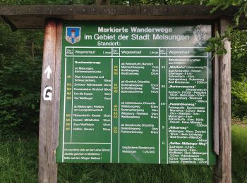
• Trail created by Stadt Melsungen. Symbol: B9 mit rotem Strich darunter
![Trail On foot Melsungen - Bartenwetzer-Rundwanderweg B4 - Photo](https://media.geolcdn.com/t/350/260/e05e4477-c8ad-47ae-9842-ad07777d5106.jpeg&format=jpg&maxdim=2)
![On foot On foot](https://static1.geolcdn.com/sitytour/trail-icons/100.png)
Km
On foot
![](/images/other/stat-length.png)
![](https://static1.geolcdn.com/siteimages/upload/files/1508320355ic_sort_den_pos_24dp.png)
![](https://static1.geolcdn.com/siteimages/upload/files/1508320355ic_sort_den_neg_24dp.png)
![](https://static1.geolcdn.com/siteimages/upload/files/16400158638029165_repeat_loop_refresh_sync_direction_icon.png)
• Trail created by Stadt Melsungen. complete Symbol: B4 mit gelbem Strich darunter
![Trail On foot Melsungen - Bartenwetzer-Rundwanderweg B2 - Photo](https://media.geolcdn.com/t/350/260/fc566561-80e2-4966-8a72-750c23275280.jpeg&format=jpg&maxdim=2)
![On foot On foot](https://static1.geolcdn.com/sitytour/trail-icons/100.png)
Km
On foot
![](/images/other/stat-length.png)
![](https://static1.geolcdn.com/siteimages/upload/files/1508320355ic_sort_den_pos_24dp.png)
![](https://static1.geolcdn.com/siteimages/upload/files/1508320355ic_sort_den_neg_24dp.png)
![](https://static1.geolcdn.com/siteimages/upload/files/16400158638029165_repeat_loop_refresh_sync_direction_icon.png)
• Trail created by Stadt Melsungen. Symbol: B2 mit blauem Strich darunter
![Trail On foot Melsungen - Bartenwetzer-Rundwanderweg B1 - Photo](https://media.geolcdn.com/t/350/260/fc566561-80e2-4966-8a72-750c23275280.jpeg&format=jpg&maxdim=2)
![On foot On foot](https://static1.geolcdn.com/sitytour/trail-icons/100.png)
Km
On foot
![](/images/other/stat-length.png)
![](https://static1.geolcdn.com/siteimages/upload/files/1508320355ic_sort_den_pos_24dp.png)
![](https://static1.geolcdn.com/siteimages/upload/files/1508320355ic_sort_den_neg_24dp.png)
![](https://static1.geolcdn.com/siteimages/upload/files/16400158638029165_repeat_loop_refresh_sync_direction_icon.png)
• Trail created by Stadt Melsungen. Symbol: B1 mit gelbem Strich darunter
![Trail On foot Melsungen - Melsunger Rundwanderweg M8 - Photo](https://media.geolcdn.com/t/350/260/fc566561-80e2-4966-8a72-750c23275280.jpeg&format=jpg&maxdim=2)
![On foot On foot](https://static1.geolcdn.com/sitytour/trail-icons/100.png)
Km
On foot
![](/images/other/stat-length.png)
![](https://static1.geolcdn.com/siteimages/upload/files/1508320355ic_sort_den_pos_24dp.png)
![](https://static1.geolcdn.com/siteimages/upload/files/1508320355ic_sort_den_neg_24dp.png)
![](https://static1.geolcdn.com/siteimages/upload/files/16400158638029165_repeat_loop_refresh_sync_direction_icon.png)
• Trail created by Stadt Melsungen. Symbol: gelber Text M8
![Trail On foot Melsungen - Melsunger Rundwanderweg M7 - Photo](https://media.geolcdn.com/t/350/260/9c04d0ce-e0f9-4749-9344-47a64fa442ee.jpeg&format=jpg&maxdim=2)
![On foot On foot](https://static1.geolcdn.com/sitytour/trail-icons/100.png)
Km
On foot
![](/images/other/stat-length.png)
![](https://static1.geolcdn.com/siteimages/upload/files/1508320355ic_sort_den_pos_24dp.png)
![](https://static1.geolcdn.com/siteimages/upload/files/1508320355ic_sort_den_neg_24dp.png)
![](https://static1.geolcdn.com/siteimages/upload/files/16400158638029165_repeat_loop_refresh_sync_direction_icon.png)
• Trail created by Stadt Melsungen. Symbol: gelber Text M7
![Trail On foot Fritzlar - Route 2 - Photo](https://media.geolcdn.com/t/350/260/a101fe02-182e-4e65-9d55-20d31747d485.jpeg&format=jpg&maxdim=2)
![On foot On foot](https://static1.geolcdn.com/sitytour/trail-icons/100.png)
Km
On foot
![](/images/other/stat-length.png)
![](https://static1.geolcdn.com/siteimages/upload/files/1508320355ic_sort_den_pos_24dp.png)
![](https://static1.geolcdn.com/siteimages/upload/files/1508320355ic_sort_den_neg_24dp.png)
![](https://static1.geolcdn.com/siteimages/upload/files/16400158638029165_repeat_loop_refresh_sync_direction_icon.png)
• Symbol: Gelbe 1 in gelbem Kreis
![Trail On foot Felsberg - Hessens Krone - Photo](https://media.geolcdn.com/t/350/260/0ec0ac91-f196-4412-b6a1-c3c86ee7b645.jpeg&format=jpg&maxdim=2)
![On foot On foot](https://static1.geolcdn.com/sitytour/trail-icons/100.png)
Km
On foot
![](/images/other/stat-length.png)
![](https://static1.geolcdn.com/siteimages/upload/files/1508320355ic_sort_den_pos_24dp.png)
![](https://static1.geolcdn.com/siteimages/upload/files/1508320355ic_sort_den_neg_24dp.png)
![](https://static1.geolcdn.com/siteimages/upload/files/16400158638029165_repeat_loop_refresh_sync_direction_icon.png)
• Trail created by Arbeitsgemeinschaft für Vor- und Frühgeschichte Gensungen e.V.. Symbol: ⌘1
![Trail On foot Melsungen - Melsunger Rundwanderweg M3 - Photo](https://media.geolcdn.com/t/350/260/e05e4477-c8ad-47ae-9842-ad07777d5106.jpeg&format=jpg&maxdim=2)
![On foot On foot](https://static1.geolcdn.com/sitytour/trail-icons/100.png)
Km
On foot
![](/images/other/stat-length.png)
![](https://static1.geolcdn.com/siteimages/upload/files/1508320355ic_sort_den_pos_24dp.png)
![](https://static1.geolcdn.com/siteimages/upload/files/1508320355ic_sort_den_neg_24dp.png)
![](https://static1.geolcdn.com/siteimages/upload/files/16400158638029165_repeat_loop_refresh_sync_direction_icon.png)
• Trail created by Stadt Melsungen. Symbol: gelber Text M3
![Trail On foot Melsungen - Melsunger Rundwanderweg M2 - Photo](https://media.geolcdn.com/t/350/260/e05e4477-c8ad-47ae-9842-ad07777d5106.jpeg&format=jpg&maxdim=2)
![On foot On foot](https://static1.geolcdn.com/sitytour/trail-icons/100.png)
Km
On foot
![](/images/other/stat-length.png)
![](https://static1.geolcdn.com/siteimages/upload/files/1508320355ic_sort_den_pos_24dp.png)
![](https://static1.geolcdn.com/siteimages/upload/files/1508320355ic_sort_den_neg_24dp.png)
![](https://static1.geolcdn.com/siteimages/upload/files/16400158638029165_repeat_loop_refresh_sync_direction_icon.png)
• Trail created by Stadt Melsungen. Symbol: gelber Text M2
![Trail On foot Melsungen - Melsunger Rundwanderweg M1 - Photo](https://media.geolcdn.com/t/350/260/e05e4477-c8ad-47ae-9842-ad07777d5106.jpeg&format=jpg&maxdim=2)
![On foot On foot](https://static1.geolcdn.com/sitytour/trail-icons/100.png)
Km
On foot
![](/images/other/stat-length.png)
![](https://static1.geolcdn.com/siteimages/upload/files/1508320355ic_sort_den_pos_24dp.png)
![](https://static1.geolcdn.com/siteimages/upload/files/1508320355ic_sort_den_neg_24dp.png)
![](https://static1.geolcdn.com/siteimages/upload/files/16400158638029165_repeat_loop_refresh_sync_direction_icon.png)
• Trail created by Stadt Melsungen. complete Symbol: gelber Text M1
![Trail On foot Felsberg - 8000 Jahre Landwirtschaft - Photo](https://media.geolcdn.com/t/350/260/6a6f7340-6e9a-4a90-9e99-39176ba63569.jpeg&format=jpg&maxdim=2)
![On foot On foot](https://static1.geolcdn.com/sitytour/trail-icons/100.png)
Km
On foot
![](/images/other/stat-length.png)
![](https://static1.geolcdn.com/siteimages/upload/files/1508320355ic_sort_den_pos_24dp.png)
![](https://static1.geolcdn.com/siteimages/upload/files/1508320355ic_sort_den_neg_24dp.png)
![](https://static1.geolcdn.com/siteimages/upload/files/16400158638029165_repeat_loop_refresh_sync_direction_icon.png)
• Trail created by Arbeitsgemeinschaft für Vor- und Frühgeschichte Gensungen e.V.. Symbol: ⌘4
![Trail On foot Homberg - HR21 - Photo](https://media.geolcdn.com/t/350/260/99cbc344-ebe1-4254-ba8a-258ec5f0b9a7.jpeg&format=jpg&maxdim=2)
![On foot On foot](https://static1.geolcdn.com/sitytour/trail-icons/100.png)
Km
On foot
![](/images/other/stat-length.png)
![](https://static1.geolcdn.com/siteimages/upload/files/1508320355ic_sort_den_pos_24dp.png)
![](https://static1.geolcdn.com/siteimages/upload/files/1508320355ic_sort_den_neg_24dp.png)
![](https://static1.geolcdn.com/siteimages/upload/files/16400158638029165_repeat_loop_refresh_sync_direction_icon.png)
• Symbol: gelber Text HR21 auf grünem Grund
20 trails displayed on 108
FREE GPS app for hiking