![](/images/other/stat-length.png)
- Trails
- On foot
- Germany
- Hesse
- Kreis Bergstraße
- Lindenfels
Lindenfels, Kreis Bergstraße, On foot: Best trails, routes and walks
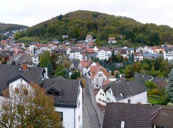
Lindenfels: Discover the best trails: 12 on foot. All these trails, routes and outdoor activities are available in our SityTrail applications for smartphones and tablets.
The best trails (12)
![Trail On foot Lindenfels - Rundwanderweg Lindenfels Weinweg 1: Ludwigsfelsen-Weg - Photo](https://media.geolcdn.com/t/350/260/c9a007a5-ee92-483f-adca-742cc86922c5.jpeg&format=jpg&maxdim=2)
![On foot On foot](https://static1.geolcdn.com/sitytour/trail-icons/100.png)
Km
On foot
![](/images/other/stat-length.png)
![](https://static1.geolcdn.com/siteimages/upload/files/1508320355ic_sort_den_pos_24dp.png)
![](https://static1.geolcdn.com/siteimages/upload/files/1508320355ic_sort_den_neg_24dp.png)
![](https://static1.geolcdn.com/siteimages/upload/files/16400158638029165_repeat_loop_refresh_sync_direction_icon.png)
• Trail created by Naturpark Neckartal-Odenwald. Symbol: Gelbe 1 in gelbem Kreis
![Trail On foot Lindenfels - Rundwanderweg Lindenfels Weinweg 4: Gersprenzquellen-Weg - Photo](https://media.geolcdn.com/t/350/260/fcc592b3-114d-496d-8742-ccf97edd0502.jpeg&format=jpg&maxdim=2)
![On foot On foot](https://static1.geolcdn.com/sitytour/trail-icons/100.png)
Km
On foot
![](/images/other/stat-length.png)
![](https://static1.geolcdn.com/siteimages/upload/files/1508320355ic_sort_den_pos_24dp.png)
![](https://static1.geolcdn.com/siteimages/upload/files/1508320355ic_sort_den_neg_24dp.png)
![](https://static1.geolcdn.com/siteimages/upload/files/16400158638029165_repeat_loop_refresh_sync_direction_icon.png)
• Trail created by Geo-Naturpark Bergstraße-Odenwald. Symbol: yellow 4 in a yellow circle
![Trail On foot Lindenfels - Rundwanderweg Schlierbach 2: Glattbach-Weg - Photo](https://media.geolcdn.com/t/350/260/b26fe5bb-f41f-49d9-8c04-f92c9c684aaa.jpeg&format=jpg&maxdim=2)
![On foot On foot](https://static1.geolcdn.com/sitytour/trail-icons/100.png)
Km
On foot
![](/images/other/stat-length.png)
![](https://static1.geolcdn.com/siteimages/upload/files/1508320355ic_sort_den_pos_24dp.png)
![](https://static1.geolcdn.com/siteimages/upload/files/1508320355ic_sort_den_neg_24dp.png)
![](https://static1.geolcdn.com/siteimages/upload/files/16400158638029165_repeat_loop_refresh_sync_direction_icon.png)
• Trail created by Geo-Naturpark Bergstraße-Odenwald. Symbol: Weißer, oben offener Kreis, in Öffnung "S", in der Mitte...
![Trail On foot Lindenfels - Rundwanderweg Glattbach 1: Schelmenacker-Weg - Photo](https://media.geolcdn.com/t/350/260/35343923-1bcb-4c55-98d6-3cdf9471244c.jpeg&format=jpg&maxdim=2)
![On foot On foot](https://static1.geolcdn.com/sitytour/trail-icons/100.png)
Km
On foot
![](/images/other/stat-length.png)
![](https://static1.geolcdn.com/siteimages/upload/files/1508320355ic_sort_den_pos_24dp.png)
![](https://static1.geolcdn.com/siteimages/upload/files/1508320355ic_sort_den_neg_24dp.png)
![](https://static1.geolcdn.com/siteimages/upload/files/16400158638029165_repeat_loop_refresh_sync_direction_icon.png)
• Trail created by Geo-Naturpark Bergstraße-Odenwald.
![Trail On foot Lindenfels - Rundwanderweg Lindenfels 5: Schlierbach-Weg - Photo](https://media.geolcdn.com/t/350/260/8df983f1-7736-4b6a-9cb1-39de288dde91.jpeg&format=jpg&maxdim=2)
![On foot On foot](https://static1.geolcdn.com/sitytour/trail-icons/100.png)
Km
On foot
![](/images/other/stat-length.png)
![](https://static1.geolcdn.com/siteimages/upload/files/1508320355ic_sort_den_pos_24dp.png)
![](https://static1.geolcdn.com/siteimages/upload/files/1508320355ic_sort_den_neg_24dp.png)
![](https://static1.geolcdn.com/siteimages/upload/files/16400158638029165_repeat_loop_refresh_sync_direction_icon.png)
• Trail created by Geo-Naturpark Bergstraße-Odenwald. Symbol: Weißer, oben offener Kreis, in Öffnung "Li", in der Mitt...
![Trail On foot Lindenfels - Rundwanderweg Lindenfels 4: Galgenberg-Weg - Photo](https://media.geolcdn.com/t/350/260/8df983f1-7736-4b6a-9cb1-39de288dde91.jpeg&format=jpg&maxdim=2)
![On foot On foot](https://static1.geolcdn.com/sitytour/trail-icons/100.png)
Km
On foot
![](/images/other/stat-length.png)
![](https://static1.geolcdn.com/siteimages/upload/files/1508320355ic_sort_den_pos_24dp.png)
![](https://static1.geolcdn.com/siteimages/upload/files/1508320355ic_sort_den_neg_24dp.png)
![](https://static1.geolcdn.com/siteimages/upload/files/16400158638029165_repeat_loop_refresh_sync_direction_icon.png)
• Trail created by Geo-Naturpark Bergstraße-Odenwald. Symbol: Weißer, oben offener Kreis, in Öffnung "Li", in der Mitt...
![Trail On foot Lindenfels - Rundwanderweg Lindenfels 2: Schenkenberg-Weg - Photo](https://media.geolcdn.com/t/350/260/1fb4d045-9776-402c-9434-9f09b6bc8411.jpeg&format=jpg&maxdim=2)
![On foot On foot](https://static1.geolcdn.com/sitytour/trail-icons/100.png)
Km
On foot
![](/images/other/stat-length.png)
![](https://static1.geolcdn.com/siteimages/upload/files/1508320355ic_sort_den_pos_24dp.png)
![](https://static1.geolcdn.com/siteimages/upload/files/1508320355ic_sort_den_neg_24dp.png)
![](https://static1.geolcdn.com/siteimages/upload/files/16400158638029165_repeat_loop_refresh_sync_direction_icon.png)
• Trail created by Geo-Naturpark Bergstraße-Odenwald. Symbol: Weißer, oben offener Kreis, in Öffnung "Li", in der Mitt...
![Trail On foot Lindenfels - Rundwanderweg Lindenfels 6: Erlebniswanderweg Lindenfels - Photo](https://media.geolcdn.com/t/350/260/1fb4d045-9776-402c-9434-9f09b6bc8411.jpeg&format=jpg&maxdim=2)
![On foot On foot](https://static1.geolcdn.com/sitytour/trail-icons/100.png)
Km
On foot
![](/images/other/stat-length.png)
![](https://static1.geolcdn.com/siteimages/upload/files/1508320355ic_sort_den_pos_24dp.png)
![](https://static1.geolcdn.com/siteimages/upload/files/1508320355ic_sort_den_neg_24dp.png)
![](https://static1.geolcdn.com/siteimages/upload/files/16400158638029165_repeat_loop_refresh_sync_direction_icon.png)
• Trail created by Odenwaldklub. Symbol: Grüner, oben offener Kreis, in Öffnung "Li", in der Mitte "6"
![Trail On foot Lindenfels - Rundwanderweg Lindenfels 1: Wanderung nach Winterkasten - Photo](https://media.geolcdn.com/t/350/260/1fb4d045-9776-402c-9434-9f09b6bc8411.jpeg&format=jpg&maxdim=2)
![On foot On foot](https://static1.geolcdn.com/sitytour/trail-icons/100.png)
Km
On foot
![](/images/other/stat-length.png)
![](https://static1.geolcdn.com/siteimages/upload/files/1508320355ic_sort_den_pos_24dp.png)
![](https://static1.geolcdn.com/siteimages/upload/files/1508320355ic_sort_den_neg_24dp.png)
![](https://static1.geolcdn.com/siteimages/upload/files/16400158638029165_repeat_loop_refresh_sync_direction_icon.png)
• Trail created by Geo-Naturpark Bergstraße-Odenwald. Symbol: Weißer, oben offener Kreis, in Öffnung "Li", in der Mitt...
![Trail On foot Lindenfels - Rundwanderweg Kolmbach 1 - Photo](https://media.geolcdn.com/t/350/260/35343923-1bcb-4c55-98d6-3cdf9471244c.jpeg&format=jpg&maxdim=2)
![On foot On foot](https://static1.geolcdn.com/sitytour/trail-icons/100.png)
Km
On foot
![](/images/other/stat-length.png)
![](https://static1.geolcdn.com/siteimages/upload/files/1508320355ic_sort_den_pos_24dp.png)
![](https://static1.geolcdn.com/siteimages/upload/files/1508320355ic_sort_den_neg_24dp.png)
![](https://static1.geolcdn.com/siteimages/upload/files/16400158638029165_repeat_loop_refresh_sync_direction_icon.png)
• Trail created by Geo-Naturpark Bergstraße-Odenwald. Symbol: white 1 in a white circle with Ko in a break at the top ...
![Trail On foot Lindenfels - Rundwanderweg Winterkasten 1 - Photo](https://media.geolcdn.com/t/350/260/35343923-1bcb-4c55-98d6-3cdf9471244c.jpeg&format=jpg&maxdim=2)
![On foot On foot](https://static1.geolcdn.com/sitytour/trail-icons/100.png)
Km
On foot
![](/images/other/stat-length.png)
![](https://static1.geolcdn.com/siteimages/upload/files/1508320355ic_sort_den_pos_24dp.png)
![](https://static1.geolcdn.com/siteimages/upload/files/1508320355ic_sort_den_neg_24dp.png)
![](https://static1.geolcdn.com/siteimages/upload/files/16400158638029165_repeat_loop_refresh_sync_direction_icon.png)
• Trail created by Geo-Naturpark Bergstraße-Odenwald. Symbol: Weißer, oben offener Kreis, in Öffnung "Wk", in der Mitt...
![Trail On foot Lindenfels - Rundwanderweg Lindenfels Weinweg 2: Angelwiesen-Weg - Photo](https://media.geolcdn.com/t/350/260/ext.jpg?maxdim=2&url=https%3A%2F%2Fstatic1.geolcdn.com%2Fsiteimages%2Fupload%2Ffiles%2F1545311037marcheuse_200dpi.jpg)
![On foot On foot](https://static1.geolcdn.com/sitytour/trail-icons/100.png)
Km
On foot
![](/images/other/stat-length.png)
![](https://static1.geolcdn.com/siteimages/upload/files/1508320355ic_sort_den_pos_24dp.png)
![](https://static1.geolcdn.com/siteimages/upload/files/1508320355ic_sort_den_neg_24dp.png)
![](https://static1.geolcdn.com/siteimages/upload/files/16400158638029165_repeat_loop_refresh_sync_direction_icon.png)
• Trail created by Geo-Naturpark Bergstraße-Odenwald. Symbol: yellow 2 in a yellow circle
12 trails displayed on 12
FREE GPS app for hiking