![](/images/other/stat-length.png)
Wegberg, Kreis Heinsberg, On foot: Best trails, routes and walks
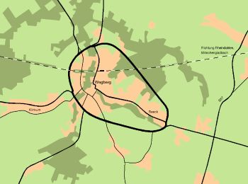
Wegberg: Discover the best trails: 23 on foot and 6 walking. All these trails, routes and outdoor activities are available in our SityTrail applications for smartphones and tablets.
The best trails (29)
![Trail On foot Wegberg - Forst Meinweg - Photo](https://media.geolcdn.com/t/350/260/5acd597a-e981-42e3-b3b2-e9aaba32fd46.jpeg&format=jpg&maxdim=2)
![On foot On foot](https://static1.geolcdn.com/sitytour/trail-icons/100.png)
Km
On foot
![](/images/other/stat-length.png)
![](https://static1.geolcdn.com/siteimages/upload/files/1508320355ic_sort_den_pos_24dp.png)
![](https://static1.geolcdn.com/siteimages/upload/files/1508320355ic_sort_den_neg_24dp.png)
![](https://static1.geolcdn.com/siteimages/upload/files/16400158638029165_repeat_loop_refresh_sync_direction_icon.png)
• Trail created by VN Niederrhein e.V.. Symbol: Schild VN Niederrhein e.V. wandern im Forst Meinweg
![Trail On foot Wegberg - Wegberger MühlenTour - Photo](https://media.geolcdn.com/t/350/260/c01bda15-9d94-4dbe-bc83-12a749039ca0.jpeg&format=jpg&maxdim=2)
![On foot On foot](https://static1.geolcdn.com/sitytour/trail-icons/100.png)
Km
On foot
![](/images/other/stat-length.png)
![](https://static1.geolcdn.com/siteimages/upload/files/1508320355ic_sort_den_pos_24dp.png)
![](https://static1.geolcdn.com/siteimages/upload/files/1508320355ic_sort_den_neg_24dp.png)
![](https://static1.geolcdn.com/siteimages/upload/files/16400158638029165_repeat_loop_refresh_sync_direction_icon.png)
• Trail created by Stadt Wegberg.
![Trail On foot Wegberg - Traumweg Dalheimer Schweiz - Photo](https://media.geolcdn.com/t/350/260/f9cc4bf4-a11f-4d55-8d46-022843fa006a.jpeg&format=jpg&maxdim=2)
![On foot On foot](https://static1.geolcdn.com/sitytour/trail-icons/100.png)
Km
On foot
![](/images/other/stat-length.png)
![](https://static1.geolcdn.com/siteimages/upload/files/1508320355ic_sort_den_pos_24dp.png)
![](https://static1.geolcdn.com/siteimages/upload/files/1508320355ic_sort_den_neg_24dp.png)
![](https://static1.geolcdn.com/siteimages/upload/files/16400158638029165_repeat_loop_refresh_sync_direction_icon.png)
• Trail created by Stadt Wegberg. Symbol: Mühlenstadt Wegberg Logo, Bild und schwarzer Wanderwegname auf grünem Grund
![Trail On foot Wegberg - Rundweg A4 Tüschenbroicher Mühle - Photo](https://media.geolcdn.com/t/350/260/ec045ffb-32f5-42ae-beae-3e043c4a39db.jpeg&format=jpg&maxdim=2)
![On foot On foot](https://static1.geolcdn.com/sitytour/trail-icons/100.png)
Km
On foot
![](/images/other/stat-length.png)
![](https://static1.geolcdn.com/siteimages/upload/files/1508320355ic_sort_den_pos_24dp.png)
![](https://static1.geolcdn.com/siteimages/upload/files/1508320355ic_sort_den_neg_24dp.png)
![](https://static1.geolcdn.com/siteimages/upload/files/16400158638029165_repeat_loop_refresh_sync_direction_icon.png)
• Trail created by Naturpark Schwalm-Nette. Symbol: Weißer Text "A4" auf schwarzem Grund
![Trail On foot Wegberg - Rundweg A4 Dalheimer Mühle - Photo](https://media.geolcdn.com/t/350/260/5acd597a-e981-42e3-b3b2-e9aaba32fd46.jpeg&format=jpg&maxdim=2)
![On foot On foot](https://static1.geolcdn.com/sitytour/trail-icons/100.png)
Km
On foot
![](/images/other/stat-length.png)
![](https://static1.geolcdn.com/siteimages/upload/files/1508320355ic_sort_den_pos_24dp.png)
![](https://static1.geolcdn.com/siteimages/upload/files/1508320355ic_sort_den_neg_24dp.png)
![](https://static1.geolcdn.com/siteimages/upload/files/16400158638029165_repeat_loop_refresh_sync_direction_icon.png)
• Trail created by Naturpark Schwalm-Nette. Symbol: Weißer Text A4 auf schwarzem Grund
![Trail On foot Wegberg - Nordic Walking Park Wegberg Route Blau - Photo](https://media.geolcdn.com/t/350/260/4b1f9a0c-5ca6-4fb2-8afc-e66812732e5d.jpeg&format=jpg&maxdim=2)
![On foot On foot](https://static1.geolcdn.com/sitytour/trail-icons/100.png)
Km
On foot
![](/images/other/stat-length.png)
![](https://static1.geolcdn.com/siteimages/upload/files/1508320355ic_sort_den_pos_24dp.png)
![](https://static1.geolcdn.com/siteimages/upload/files/1508320355ic_sort_den_neg_24dp.png)
![](https://static1.geolcdn.com/siteimages/upload/files/16400158638029165_repeat_loop_refresh_sync_direction_icon.png)
• Trail created by Stadt Wegberg. Symbol: Rautenförmiges Schild mit Nordic Walker Symbol, Blauer Pfeil in orangem Kreis
![Trail On foot Wegberg - Rundweg](https://media.geolcdn.com/t/350/260/4b1f9a0c-5ca6-4fb2-8afc-e66812732e5d.jpeg&format=jpg&maxdim=2)
![On foot On foot](https://static1.geolcdn.com/sitytour/trail-icons/100.png)
Km
On foot
![](/images/other/stat-length.png)
![](https://static1.geolcdn.com/siteimages/upload/files/1508320355ic_sort_den_pos_24dp.png)
![](https://static1.geolcdn.com/siteimages/upload/files/1508320355ic_sort_den_neg_24dp.png)
![](https://static1.geolcdn.com/siteimages/upload/files/16400158638029165_repeat_loop_refresh_sync_direction_icon.png)
• Trail created by Naturpark Schwalm-Nette.
![Trail On foot Wegberg - Rundweg A3 Beecker Wald - Photo](https://media.geolcdn.com/t/350/260/3bddd96f-b54a-4897-8eb6-09913595b9df.jpeg&format=jpg&maxdim=2)
![On foot On foot](https://static1.geolcdn.com/sitytour/trail-icons/100.png)
Km
On foot
![](/images/other/stat-length.png)
![](https://static1.geolcdn.com/siteimages/upload/files/1508320355ic_sort_den_pos_24dp.png)
![](https://static1.geolcdn.com/siteimages/upload/files/1508320355ic_sort_den_neg_24dp.png)
![](https://static1.geolcdn.com/siteimages/upload/files/16400158638029165_repeat_loop_refresh_sync_direction_icon.png)
• Trail created by Naturpark Schwalm-Nette.
![Trail On foot Wegberg - Traumweg Wildes Schaagbachtal - Photo](https://media.geolcdn.com/t/350/260/d22fc2b6-b7dc-41c2-9de0-035e6d67964c.jpeg&format=jpg&maxdim=2)
![On foot On foot](https://static1.geolcdn.com/sitytour/trail-icons/100.png)
Km
On foot
![](/images/other/stat-length.png)
![](https://static1.geolcdn.com/siteimages/upload/files/1508320355ic_sort_den_pos_24dp.png)
![](https://static1.geolcdn.com/siteimages/upload/files/1508320355ic_sort_den_neg_24dp.png)
![](https://static1.geolcdn.com/siteimages/upload/files/16400158638029165_repeat_loop_refresh_sync_direction_icon.png)
• Trail created by Stadt Wegberg. Symbol: Mühlenstadt Wegberg Logo, Bild und schwarzer Wanderwegname auf grünem Grund
![Trail On foot Wegberg - Rundweg Beecker Wald A2 - Photo](https://media.geolcdn.com/t/350/260/d9db701b-e7a2-4143-b264-985304917219.jpeg&format=jpg&maxdim=2)
![On foot On foot](https://static1.geolcdn.com/sitytour/trail-icons/100.png)
Km
On foot
![](/images/other/stat-length.png)
![](https://static1.geolcdn.com/siteimages/upload/files/1508320355ic_sort_den_pos_24dp.png)
![](https://static1.geolcdn.com/siteimages/upload/files/1508320355ic_sort_den_neg_24dp.png)
![](https://static1.geolcdn.com/siteimages/upload/files/16400158638029165_repeat_loop_refresh_sync_direction_icon.png)
• Trail created by Naturpark Schwalm-Nette. Symbol: Weißer Text "A2" auf schwarzem Grund
![Trail On foot Wegberg - Rundweg A1 Arsbecker Meinweg - Photo](https://media.geolcdn.com/t/350/260/5acd597a-e981-42e3-b3b2-e9aaba32fd46.jpeg&format=jpg&maxdim=2)
![On foot On foot](https://static1.geolcdn.com/sitytour/trail-icons/100.png)
Km
On foot
![](/images/other/stat-length.png)
![](https://static1.geolcdn.com/siteimages/upload/files/1508320355ic_sort_den_pos_24dp.png)
![](https://static1.geolcdn.com/siteimages/upload/files/1508320355ic_sort_den_neg_24dp.png)
![](https://static1.geolcdn.com/siteimages/upload/files/16400158638029165_repeat_loop_refresh_sync_direction_icon.png)
• Trail created by Naturpark Schwalm-Nette. Symbol: Weißer Text A1 auf schwarzem Grund
![Trail On foot Wegberg - Rundweg A6 Papelter Bruch - Photo](https://media.geolcdn.com/t/350/260/002dbc82-401e-4dbd-bc7a-52e6686ac285.jpeg&format=jpg&maxdim=2)
![On foot On foot](https://static1.geolcdn.com/sitytour/trail-icons/100.png)
Km
On foot
![](/images/other/stat-length.png)
![](https://static1.geolcdn.com/siteimages/upload/files/1508320355ic_sort_den_pos_24dp.png)
![](https://static1.geolcdn.com/siteimages/upload/files/1508320355ic_sort_den_neg_24dp.png)
![](https://static1.geolcdn.com/siteimages/upload/files/16400158638029165_repeat_loop_refresh_sync_direction_icon.png)
• Trail created by Naturpark Schwalm-Nette. Symbol: Weißer Text A6 auf schwarzem Grund
![Trail On foot Wegberg - Rundweg A5 Lüttelforst - Photo](https://media.geolcdn.com/t/350/260/002dbc82-401e-4dbd-bc7a-52e6686ac285.jpeg&format=jpg&maxdim=2)
![On foot On foot](https://static1.geolcdn.com/sitytour/trail-icons/100.png)
Km
On foot
![](/images/other/stat-length.png)
![](https://static1.geolcdn.com/siteimages/upload/files/1508320355ic_sort_den_pos_24dp.png)
![](https://static1.geolcdn.com/siteimages/upload/files/1508320355ic_sort_den_neg_24dp.png)
![](https://static1.geolcdn.com/siteimages/upload/files/16400158638029165_repeat_loop_refresh_sync_direction_icon.png)
• Trail created by Naturpark Schwalm-Nette. Symbol: Weißer Text A5 auf schwarzem Grund
![Trail On foot Wegberg - Nordic Walking Park Wegberg Route Grün - Photo](https://media.geolcdn.com/t/350/260/3bddd96f-b54a-4897-8eb6-09913595b9df.jpeg&format=jpg&maxdim=2)
![On foot On foot](https://static1.geolcdn.com/sitytour/trail-icons/100.png)
Km
On foot
![](/images/other/stat-length.png)
![](https://static1.geolcdn.com/siteimages/upload/files/1508320355ic_sort_den_pos_24dp.png)
![](https://static1.geolcdn.com/siteimages/upload/files/1508320355ic_sort_den_neg_24dp.png)
![](https://static1.geolcdn.com/siteimages/upload/files/16400158638029165_repeat_loop_refresh_sync_direction_icon.png)
• Trail created by Stadt Wegberg. Symbol: Rautenförmiges Schild mit Nordic Walker Symbol, Grüner Pfeil in orangem Kreis
![Trail On foot Wegberg - Nordic Walking Park Wegberg Route Rot - Photo](https://media.geolcdn.com/t/350/260/d9db701b-e7a2-4143-b264-985304917219.jpeg&format=jpg&maxdim=2)
![On foot On foot](https://static1.geolcdn.com/sitytour/trail-icons/100.png)
Km
On foot
![](/images/other/stat-length.png)
![](https://static1.geolcdn.com/siteimages/upload/files/1508320355ic_sort_den_pos_24dp.png)
![](https://static1.geolcdn.com/siteimages/upload/files/1508320355ic_sort_den_neg_24dp.png)
![](https://static1.geolcdn.com/siteimages/upload/files/16400158638029165_repeat_loop_refresh_sync_direction_icon.png)
• Trail created by Stadt Wegberg. Symbol: Rautenförmiges Schild mit Nordic Walker Symbol, Roter Pfeil in orangem Kreis
![Trail On foot Wegberg - Nordic Walking Park Wegberg Route Braun - Photo](https://media.geolcdn.com/t/350/260/9e1de05f-ab49-4907-b56d-95fd73646167.jpeg&format=jpg&maxdim=2)
![On foot On foot](https://static1.geolcdn.com/sitytour/trail-icons/100.png)
Km
On foot
![](/images/other/stat-length.png)
![](https://static1.geolcdn.com/siteimages/upload/files/1508320355ic_sort_den_pos_24dp.png)
![](https://static1.geolcdn.com/siteimages/upload/files/1508320355ic_sort_den_neg_24dp.png)
![](https://static1.geolcdn.com/siteimages/upload/files/16400158638029165_repeat_loop_refresh_sync_direction_icon.png)
• Trail created by Stadt Wegberg. Symbol: Rautenförmiges Schild mit Nordic Walker Symbol, Brauner Pfeil in orangem Kreis
![Trail On foot Wegberg - Birgeler Urwald - Photo](https://media.geolcdn.com/t/350/260/d22fc2b6-b7dc-41c2-9de0-035e6d67964c.jpeg&format=jpg&maxdim=2)
![On foot On foot](https://static1.geolcdn.com/sitytour/trail-icons/100.png)
Km
On foot
![](/images/other/stat-length.png)
![](https://static1.geolcdn.com/siteimages/upload/files/1508320355ic_sort_den_pos_24dp.png)
![](https://static1.geolcdn.com/siteimages/upload/files/1508320355ic_sort_den_neg_24dp.png)
![](https://static1.geolcdn.com/siteimages/upload/files/16400158638029165_repeat_loop_refresh_sync_direction_icon.png)
• Trail created by Naturpark Schwalm Nette. Symbol: Weisses, geschwungenes "W" auf blauem Rechteck. Text oben Wasser.W...
![Trail On foot Wegberg - Rundweg](https://media.geolcdn.com/t/350/260/ext.jpg?maxdim=2&url=https%3A%2F%2Fstatic1.geolcdn.com%2Fsiteimages%2Fupload%2Ffiles%2F1545311037marcheuse_200dpi.jpg)
![On foot On foot](https://static1.geolcdn.com/sitytour/trail-icons/100.png)
Km
On foot
![](/images/other/stat-length.png)
![](https://static1.geolcdn.com/siteimages/upload/files/1508320355ic_sort_den_pos_24dp.png)
![](https://static1.geolcdn.com/siteimages/upload/files/1508320355ic_sort_den_neg_24dp.png)
![](https://static1.geolcdn.com/siteimages/upload/files/16400158638029165_repeat_loop_refresh_sync_direction_icon.png)
• Trail created by Naturpark Schwalm-Nette. Symbol: Weißer Text "A1" auf schwarzem Grund
![Trail On foot Wegberg - Rundweg A8 Schaagbachtal - Photo](https://media.geolcdn.com/t/350/260/ext.jpg?maxdim=2&url=https%3A%2F%2Fstatic1.geolcdn.com%2Fsiteimages%2Fupload%2Ffiles%2F1545311037marcheuse_200dpi.jpg)
![On foot On foot](https://static1.geolcdn.com/sitytour/trail-icons/100.png)
Km
On foot
![](/images/other/stat-length.png)
![](https://static1.geolcdn.com/siteimages/upload/files/1508320355ic_sort_den_pos_24dp.png)
![](https://static1.geolcdn.com/siteimages/upload/files/1508320355ic_sort_den_neg_24dp.png)
![](https://static1.geolcdn.com/siteimages/upload/files/16400158638029165_repeat_loop_refresh_sync_direction_icon.png)
• Trail created by Naturpark Schwalm-Nette. nur in einer Richtung gezeichnet Symbol: Weißer Text "A8" auf schwarzem G...
![Trail On foot Wegberg - Nordic Walking Park Wegberg Route Rosa - Photo](https://media.geolcdn.com/t/350/260/ext.jpg?maxdim=2&url=https%3A%2F%2Fstatic1.geolcdn.com%2Fsiteimages%2Fupload%2Ffiles%2F1545311037marcheuse_200dpi.jpg)
![On foot On foot](https://static1.geolcdn.com/sitytour/trail-icons/100.png)
Km
On foot
![](/images/other/stat-length.png)
![](https://static1.geolcdn.com/siteimages/upload/files/1508320355ic_sort_den_pos_24dp.png)
![](https://static1.geolcdn.com/siteimages/upload/files/1508320355ic_sort_den_neg_24dp.png)
![](https://static1.geolcdn.com/siteimages/upload/files/16400158638029165_repeat_loop_refresh_sync_direction_icon.png)
• Trail created by Stadt Wegberg. Symbol: Rautenförmiges Schild mit Nordic Walker Symbol, Rosa Pfeil in orangem Kreis
20 trails displayed on 29
FREE GPS app for hiking