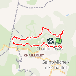
![](/images/other/stat-length.png)
![Tour Wandern Saint-Michel-de-Chaillol - R39 Marmottes et Canal de Chaillol - Photo](https://media.geolcdn.com/t/1900/400/393c0b09-00e6-49e7-9964-e52bbdf6a5b5.jpg&format=pjpeg&maxdim=2)
R39 Marmottes et Canal de Chaillol
Camping Les Rives du Lac
Les Hautes Alpes à découvrir ! GUIDE+
![Länge](/images/other/stat-length.png)
![Maximale Höhe](https://static1.geolcdn.com/siteimages/upload/files/1508320355ic_sort_altitude_max_24dp.png)
![Positive Höhendifferenz](https://static1.geolcdn.com/siteimages/upload/files/1508320355ic_sort_den_pos_24dp.png)
![Km-Effort](/images/other/stat-length.png)
![Min. Höhe](https://static1.geolcdn.com/siteimages/upload/files/1508320355ic_sort_altitude_min_24dp.png)
![Negative Höhendifferenz](https://static1.geolcdn.com/siteimages/upload/files/1508320355ic_sort_den_neg_24dp.png)
![Boucle](https://static1.geolcdn.com/siteimages/upload/files/16400158638029165_repeat_loop_refresh_sync_direction_icon.png)
![Wandern](https://static1.geolcdn.com/sitytour/trail-icons/101.png)
2h32
Schwierigkeit : Unbekannt
![Scannen Sie diesen QR-Code, um die Tour in der SityTrail-Anwendung zu öffnen](https://capi.geolives.com/qq0zvz2zws4bq2lad0pu/sitytour/trails/891553/qr.png?size=200)
Kostenlosegpshiking-Anwendung
Über SityTrail
Tour Wandern von 7,1 km verfügbar auf Provence-Alpes-Côte d'Azur, Hochalpen, Saint-Michel-de-Chaillol. Diese Tour wird von Camping Les Rives du Lac vorgeschlagen.
Beschreibung
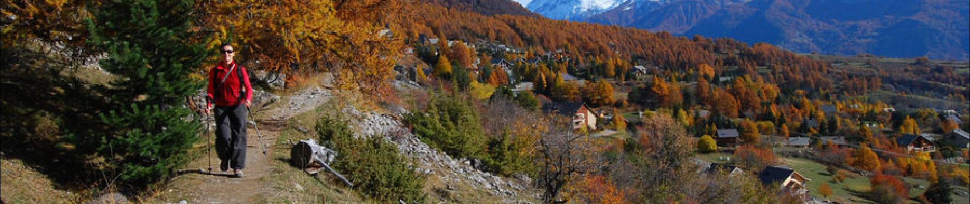
At the start of the Malcros canal trail, in the scree, live several marmots. They will be more visible in the morning or at the end of the afternoon. The trail that lasts 2 hours is interesting. It offers magnificent views of the Champsaur valley and traces the history of the canal (61 km long, begun in 1873 and abandoned in 1923) which was to irrigate the lands from the Malcros Glacier.
Ort
Kommentare
Touren in der Umgebung
![Tour Wandern Saint-Jean-Saint-Nicolas - Circuit de Costebelle - Photo](https://media.geolcdn.com/t/375/260/ext.jpg?maxdim=2&url=https%3A%2F%2Fservices.sitytrail.com%2FGeolivesWS%2FDownloadMedia.ashx%3FTrailID%3D269960%26Media%3Dfix__20140424150455.jpg)
![Wandern Wandern](https://static1.geolcdn.com/sitytour/trail-icons/101.png)
Wandern
![](/images/other/stat-length.png)
![](https://static1.geolcdn.com/siteimages/upload/files/16400158638029165_repeat_loop_refresh_sync_direction_icon.png)
![Tour Wandern Saint-Bonnet-en-Champsaur - Les infournas - Lac des Barbeyroux 22/09/23 - Photo](https://media.geolcdn.com/t/375/260/0538c280-feb5-4d65-96e8-19b0b69c47f0.jpg&format=jpg&maxdim=2)
![Wandern Wandern](https://static1.geolcdn.com/sitytour/trail-icons/101.png)
Wandern
![](/images/other/stat-length.png)
![](https://static1.geolcdn.com/siteimages/upload/files/16400158638029165_repeat_loop_refresh_sync_direction_icon.png)
![Tour Wandern Saint-Michel-de-Chaillol - Col de l'Escalier - Photo](https://media.geolcdn.com/t/375/260/ab16f81e-2013-445c-8eb3-48638c0edd61.jpg&format=jpg&maxdim=2)
![Wandern Wandern](https://static1.geolcdn.com/sitytour/trail-icons/101.png)
Wandern
![](/images/other/stat-length.png)
![](https://static1.geolcdn.com/siteimages/upload/files/16400158638029165_repeat_loop_refresh_sync_direction_icon.png)
![Tour Wandern Saint-Michel-de-Chaillol - Pic Queyrel - Photo](https://media.geolcdn.com/t/375/260/3587472a-93b3-4434-9291-823cc836fe6a.jpg&format=jpg&maxdim=2)
![Wandern Wandern](https://static1.geolcdn.com/sitytour/trail-icons/101.png)
Wandern
![](/images/other/stat-length.png)
![](https://static1.geolcdn.com/siteimages/upload/files/16400158638029165_repeat_loop_refresh_sync_direction_icon.png)
![Tour Wandern Saint-Michel-de-Chaillol - Pic du Tourond - Photo](https://media.geolcdn.com/t/375/260/01ce6341-dc1d-4078-9a13-caf8c777653c.jpg&format=jpg&maxdim=2)
![Wandern Wandern](https://static1.geolcdn.com/sitytour/trail-icons/101.png)
Wandern
![](/images/other/stat-length.png)
![](https://static1.geolcdn.com/siteimages/upload/files/16400158638029165_repeat_loop_refresh_sync_direction_icon.png)
![Tour Wandern Saint-Michel-de-Chaillol - Lac de Malcros - Photo](https://media.geolcdn.com/t/375/260/6a7a1b5d-0b23-46a5-9179-bf8c821d0afb.jpg&format=jpg&maxdim=2)
![Wandern Wandern](https://static1.geolcdn.com/sitytour/trail-icons/101.png)
Wandern
![](/images/other/stat-length.png)
![](https://static1.geolcdn.com/siteimages/upload/files/16400158638029165_repeat_loop_refresh_sync_direction_icon.png)
![Tour Wandern Saint-Michel-de-Chaillol - pic de queyrel - Photo](https://media.geolcdn.com/t/375/260/16bf5dfe-1e8f-41f7-8280-542f457efdf9.jpg&format=jpg&maxdim=2)
![Wandern Wandern](https://static1.geolcdn.com/sitytour/trail-icons/101.png)
Wandern
![](/images/other/stat-length.png)
![](https://static1.geolcdn.com/siteimages/upload/files/16400158638029165_repeat_loop_refresh_sync_direction_icon.png)
![Tour Wandern Saint-Michel-de-Chaillol - Tête ouest de Mal Cros 11/08/18 - Photo](https://media.geolcdn.com/t/375/260/8702d498-6db2-40a6-b115-ed3ce3d7c0b6.jpg&format=jpg&maxdim=2)
![Wandern Wandern](https://static1.geolcdn.com/sitytour/trail-icons/101.png)
Wandern
![](/images/other/stat-length.png)
![](https://static1.geolcdn.com/siteimages/upload/files/16400158638029165_repeat_loop_refresh_sync_direction_icon.png)
![Tour Wandern Saint-Jean-Saint-Nicolas - Pont Ricous Pelissier Coste Belle Pont du Fossé - Photo](https://media.geolcdn.com/t/375/260/ext.jpg?maxdim=2&url=https%3A%2F%2Fstatic1.geolcdn.com%2Fsiteimages%2Fupload%2Ffiles%2F1553511878bg_sport_marche.png)
![Wandern Wandern](https://static1.geolcdn.com/sitytour/trail-icons/101.png)
Wandern
![](/images/other/stat-length.png)
![](https://static1.geolcdn.com/siteimages/upload/files/16400158638029165_repeat_loop_refresh_sync_direction_icon.png)