![](/images/other/stat-length.png)
![Tour Wandern Narbonne - Visorando - Randonnée Massif de Fontfroide - Photo](https://media.geolcdn.com/t/1900/400/ext.pjpeg?maxdim=2&url=https%3A%2F%2Fstatic1.geolcdn.com%2Fsiteimages%2Fupload%2Ffiles%2F1553511878bg_sport_marche.png)
Visorando - Randonnée Massif de Fontfroide
cbouttes
Benutzer
![Länge](/images/other/stat-length.png)
![Maximale Höhe](https://static1.geolcdn.com/siteimages/upload/files/1508320355ic_sort_altitude_max_24dp.png)
![Positive Höhendifferenz](https://static1.geolcdn.com/siteimages/upload/files/1508320355ic_sort_den_pos_24dp.png)
![Km-Effort](/images/other/stat-length.png)
![Min. Höhe](https://static1.geolcdn.com/siteimages/upload/files/1508320355ic_sort_altitude_min_24dp.png)
![Negative Höhendifferenz](https://static1.geolcdn.com/siteimages/upload/files/1508320355ic_sort_den_neg_24dp.png)
![Boucle](https://static1.geolcdn.com/siteimages/upload/files/16400158638029165_repeat_loop_refresh_sync_direction_icon.png)
![Wandern](https://static1.geolcdn.com/sitytour/trail-icons/101.png)
3h06
Schwierigkeit : Unbekannt
![Scannen Sie diesen QR-Code, um die Tour in der SityTrail-Anwendung zu öffnen](https://capi.geolives.com/qq0zvz2zws4bq2lad0pu/sitytour/trails/711803/qr.png?size=200)
Kostenlosegpshiking-Anwendung
Über SityTrail
Tour Wandern von 11,3 km verfügbar auf Okzitanien, Aude, Narbonne. Diese Tour wird von cbouttes vorgeschlagen.
Beschreibung
https://www.visorando.com/randonnee-massif-de-fontfroide/
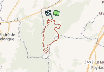
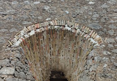
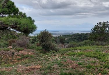
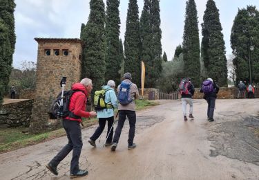
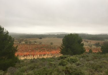
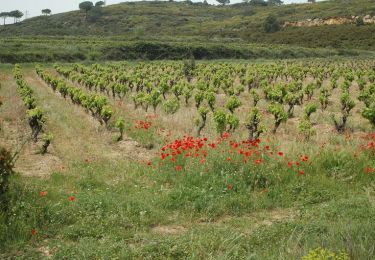
Une boucle depuis la magnifique Abbaye de Fontfroide dans le massif du même nom. Des points de vue à 360° sur les Corbiéres, les Pyrénées et le littoral audois.Sans grosse difficulté, le tracé n'emprunte que les chemins DFCI de ce massif très protégé.Durée Durée moyenne: 3h40 [?]Distance Distance : 11.27kmDénivelé positif Dénivelé positif : 171mDénivelé négatif Dénivelé négatif : 171mPoint haut Point haut : 241mPoint bas Point bas : 111m Facile Difficulté : FacileRetour point de départ Retour point de départ : OuiA pied A piedCommune Commune : Narbonne (11100)Départ Départ : N 43.129953° / E 2.895822°
Ort
Kommentare
Touren in der Umgebung
![Tour Andere Aktivitäten Bizanet - Abbaye de Fontdefroide - Photo](https://media.geolcdn.com/t/375/260/ext.jpg?maxdim=2&url=https%3A%2F%2Fservices.sitytrail.com%2FGeolivesWS%2FDownloadMedia.ashx%3FTrailID%3D458985%26Media%3D20150814175939.jpg)
![Andere Aktivitäten Andere Aktivitäten](https://static1.geolcdn.com/sitytour/trail-icons/900.png)
Andere Aktivitäten
![](/images/other/stat-length.png)
![](https://static1.geolcdn.com/siteimages/upload/files/16400158638029165_repeat_loop_refresh_sync_direction_icon.png)
![Tour Wandern Narbonne - bois de Fontfroide - Photo](https://media.geolcdn.com/t/375/260/04a41b67-1fb3-45d4-94a9-cff686aa19ae.jpg&format=jpg&maxdim=2)
![Wandern Wandern](https://static1.geolcdn.com/sitytour/trail-icons/101.png)
Wandern
![](/images/other/stat-length.png)
![](https://static1.geolcdn.com/siteimages/upload/files/16400158638029165_repeat_loop_refresh_sync_direction_icon.png)
![Tour Wandern Narbonne - L'Aragnon de Frontfroide - Photo](https://media.geolcdn.com/t/375/260/ext.jpg?maxdim=2&url=https%3A%2F%2Fstatic1.geolcdn.com%2Fsiteimages%2Fupload%2Ffiles%2F1553511878bg_sport_marche.png)
![Wandern Wandern](https://static1.geolcdn.com/sitytour/trail-icons/101.png)
Wandern
![](/images/other/stat-length.png)
![](https://static1.geolcdn.com/siteimages/upload/files/16400158638029165_repeat_loop_refresh_sync_direction_icon.png)
![Tour Wandern Saint-André-de-Roquelongue - ACAD - TBG - Saint-Andre-de-Roquelongue reco 23 octobre - Photo](https://media.geolcdn.com/t/375/260/77fdfb1e-6863-402e-bac4-396dcd015702.jpg&format=jpg&maxdim=2)
![Wandern Wandern](https://static1.geolcdn.com/sitytour/trail-icons/101.png)
Wandern
![](/images/other/stat-length.png)
![](https://static1.geolcdn.com/siteimages/upload/files/16400158638029165_repeat_loop_refresh_sync_direction_icon.png)
![Tour Wandern Narbonne - La combe d'enfer en Narbonnais - Photo](https://media.geolcdn.com/t/375/260/28cc313a-8a47-482c-81b5-28081d16a224.jpg&format=jpg&maxdim=2)
![Wandern Wandern](https://static1.geolcdn.com/sitytour/trail-icons/101.png)
Wandern
![](/images/other/stat-length.png)
![](https://static1.geolcdn.com/siteimages/upload/files/16400158638029165_repeat_loop_refresh_sync_direction_icon.png)
![Tour Wandern Narbonne - Fontfroide (aude) Près de Narbonne - Photo](https://media.geolcdn.com/t/375/260/740c9163-f8f4-4dac-b59d-2c6335707879.jpg&format=jpg&maxdim=2)
![Wandern Wandern](https://static1.geolcdn.com/sitytour/trail-icons/101.png)
Wandern
![](/images/other/stat-length.png)
![](https://static1.geolcdn.com/siteimages/upload/files/16400158638029165_repeat_loop_refresh_sync_direction_icon.png)
![Tour Wandern Bages - Prat-de-Cest - Abbaye de Fontfroide - Photo](https://media.geolcdn.com/t/375/260/fd3516f0-d21c-487d-b7cc-d412f56ad9ce.jpg&format=jpg&maxdim=2)
![Wandern Wandern](https://static1.geolcdn.com/sitytour/trail-icons/101.png)
Wandern
![](/images/other/stat-length.png)
![](https://static1.geolcdn.com/siteimages/upload/files/16400158638029165_repeat_loop_refresh_sync_direction_icon.png)
![Tour Wandern Bizanet - Bizanet - Photo](https://media.geolcdn.com/t/375/260/ext.jpg?maxdim=2&url=https%3A%2F%2Fservices.sitytrail.com%2FGeolivesWS%2FDownloadMedia.ashx%3FTrailID%3D172253%26Media%3D8562_5.jpg)
![Wandern Wandern](https://static1.geolcdn.com/sitytour/trail-icons/101.png)
![Tour Wandern Narbonne - Narbonne Etang De Jonquières - Photo](https://media.geolcdn.com/t/375/260/ext.jpg?maxdim=2&url=https%3A%2F%2Fservices.sitytrail.com%2FGeolivesWS%2FDownloadMedia.ashx%3FTrailID%3D121016%26Media%3D20120410133338.jpg)
![Wandern Wandern](https://static1.geolcdn.com/sitytour/trail-icons/101.png)
Wandern
![](/images/other/stat-length.png)
![](https://static1.geolcdn.com/siteimages/upload/files/16400158638029165_repeat_loop_refresh_sync_direction_icon.png)