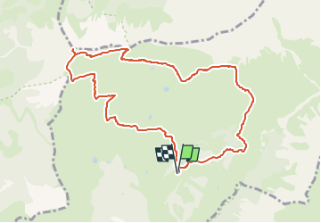
![](/images/other/stat-length.png)
![Tour Wandern St. Christina in Gröden - Col Raiser - Secëda - Forcella Pana - Rifugio Firenze - Photo](https://media.geolcdn.com/t/1900/400/ext.pjpeg?maxdim=2&url=https%3A%2F%2Fstatic1.geolcdn.com%2Fsiteimages%2Fupload%2Ffiles%2F1553511878bg_sport_marche.png)
Col Raiser - Secëda - Forcella Pana - Rifugio Firenze
suntajl
Benutzer
![Länge](/images/other/stat-length.png)
![Maximale Höhe](https://static1.geolcdn.com/siteimages/upload/files/1508320355ic_sort_altitude_max_24dp.png)
![Positive Höhendifferenz](https://static1.geolcdn.com/siteimages/upload/files/1508320355ic_sort_den_pos_24dp.png)
![Km-Effort](/images/other/stat-length.png)
![Min. Höhe](https://static1.geolcdn.com/siteimages/upload/files/1508320355ic_sort_altitude_min_24dp.png)
![Negative Höhendifferenz](https://static1.geolcdn.com/siteimages/upload/files/1508320355ic_sort_den_neg_24dp.png)
![Boucle](https://static1.geolcdn.com/siteimages/upload/files/16400158638029165_repeat_loop_refresh_sync_direction_icon.png)
![Wandern](https://static1.geolcdn.com/sitytour/trail-icons/101.png)
3h46
Schwierigkeit : Schwierig
![Scannen Sie diesen QR-Code, um die Tour in der SityTrail-Anwendung zu öffnen](https://capi.geolives.com/qq0zvz2zws4bq2lad0pu/sitytour/trails/4129264/qr.png?size=200)
Kostenlosegpshiking-Anwendung
Über SityTrail
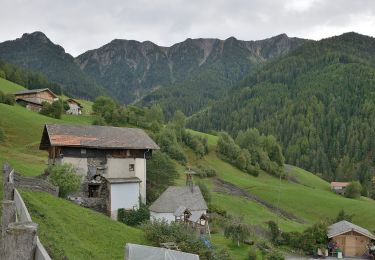
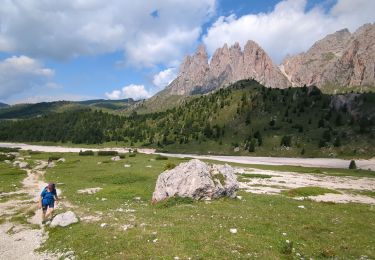
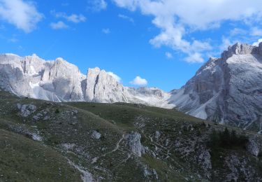
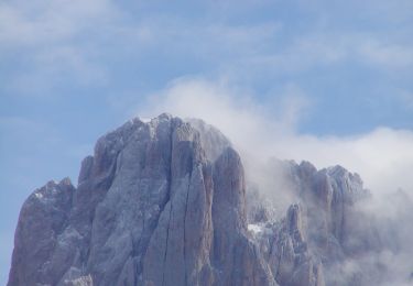
Tour Wandern von 9,8 km verfügbar auf Trentino-Südtirol, Bozen, St. Christina in Gröden. Diese Tour wird von suntajl vorgeschlagen.
Beschreibung
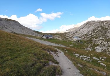
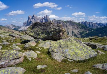
Excellent chemin jusque Fermeda; plus étroit mais bien tracé jusqu'au refuge Firenze. Avis partagés quant au sens de la balade: j'ai choisi le sens horaire surtout pour une question de météo plus ensoleillée le matin. Beaucoup de monde dans les 2 sens mi-septembre sur le trajet Seceda-Pieralongia
Ort
Kommentare
Touren in der Umgebung
![Tour Zu Fuß Wolkenstein - (SI C21N) Selva di Val Gardena - Rifugio Puez - Photo](https://media.geolcdn.com/t/375/260/37a3edca-92b3-4b7c-b813-71fb6d1f0fc5.jpeg&format=jpg&maxdim=2)
![Zu Fuß Zu Fuß](https://static1.geolcdn.com/sitytour/trail-icons/100.png)
Zu Fuß
![](/images/other/stat-length.png)
![](https://static1.geolcdn.com/siteimages/upload/files/16400158638029165_repeat_loop_refresh_sync_direction_icon.png)
![Tour Zu Fuß St. Christina in Gröden - IT-20 - Photo](https://media.geolcdn.com/t/375/260/fc4a1fa0-4048-4524-8901-47075ed3c119.jpeg&format=jpg&maxdim=2)
![Zu Fuß Zu Fuß](https://static1.geolcdn.com/sitytour/trail-icons/100.png)
Zu Fuß
![](/images/other/stat-length.png)
![](https://static1.geolcdn.com/siteimages/upload/files/16400158638029165_repeat_loop_refresh_sync_direction_icon.png)
![Tour Wandern St. Christina in Gröden - Col Raiser - Pieralonga - Seceda - Photo](https://media.geolcdn.com/t/375/260/a584e920-364e-4681-acf4-e9ea40aa98e0.jpg&format=jpg&maxdim=2)
![Wandern Wandern](https://static1.geolcdn.com/sitytour/trail-icons/101.png)
Wandern
![](/images/other/stat-length.png)
![](https://static1.geolcdn.com/siteimages/upload/files/16400158638029165_repeat_loop_refresh_sync_direction_icon.png)
![Tour Zu Fuß St. Christina in Gröden - Rundgang Traditioneller Höfe - Photo](https://media.geolcdn.com/t/375/260/aca93379-5cc6-4da3-8352-0bd88eae00ae.jpeg&format=jpg&maxdim=2)
![Zu Fuß Zu Fuß](https://static1.geolcdn.com/sitytour/trail-icons/100.png)
Zu Fuß
![](/images/other/stat-length.png)
![](https://static1.geolcdn.com/siteimages/upload/files/16400158638029165_repeat_loop_refresh_sync_direction_icon.png)
![Tour Zu Fuß St. Christina in Gröden - Klettersteig Sas Rigais - Photo](https://media.geolcdn.com/t/375/260/e83cb540-17ca-4b2b-9b64-a496b1a86928.jpeg&format=jpg&maxdim=2)
![Zu Fuß Zu Fuß](https://static1.geolcdn.com/sitytour/trail-icons/100.png)
Zu Fuß
![](/images/other/stat-length.png)
![](https://static1.geolcdn.com/siteimages/upload/files/16400158638029165_repeat_loop_refresh_sync_direction_icon.png)
![Tour Zu Fuß St. Christina in Gröden - Raida dl luech - Photo](https://media.geolcdn.com/t/375/260/9fb7aa02-2ee9-42b2-938a-2ae13991006d.jpeg&format=jpg&maxdim=2)
![Zu Fuß Zu Fuß](https://static1.geolcdn.com/sitytour/trail-icons/100.png)
Zu Fuß
![](/images/other/stat-length.png)
![](https://static1.geolcdn.com/siteimages/upload/files/16400158638029165_repeat_loop_refresh_sync_direction_icon.png)
![Tour Zu Fuß Kastelruth - IT-11 - Photo](https://media.geolcdn.com/t/375/260/ec184f22-11a0-4f04-9f34-2b372ec2edfd.jpeg&format=jpg&maxdim=2)
![Zu Fuß Zu Fuß](https://static1.geolcdn.com/sitytour/trail-icons/100.png)
Zu Fuß
![](/images/other/stat-length.png)
![](https://static1.geolcdn.com/siteimages/upload/files/16400158638029165_repeat_loop_refresh_sync_direction_icon.png)
![Tour Zu Fuß St. Ulrich in Gröden - IT-10 - Photo](https://media.geolcdn.com/t/375/260/da4beb5d-d9d9-4b04-8d6e-e82d21950496.jpeg&format=jpg&maxdim=2)
![Zu Fuß Zu Fuß](https://static1.geolcdn.com/sitytour/trail-icons/100.png)
Zu Fuß
![](/images/other/stat-length.png)
![](https://static1.geolcdn.com/siteimages/upload/files/16400158638029165_repeat_loop_refresh_sync_direction_icon.png)
![Tour Zu Fuß Villnöß - IT-31 - Photo](https://media.geolcdn.com/t/375/260/a2a7006e-b6a2-43ae-afbd-3d0cf0db5dae.jpeg&format=jpg&maxdim=2)
![Zu Fuß Zu Fuß](https://static1.geolcdn.com/sitytour/trail-icons/100.png)