![](/images/other/stat-length.png)
![Tour Elektrofahrrad Gréolières - boucle du col de Bleine en partant de Gréolières - Photo](https://media.geolcdn.com/t/1900/400/ext.pjpeg?maxdim=2&url=https%3A%2F%2Fstatic1.geolcdn.com%2Fsiteimages%2Fupload%2Ffiles%2F1524743154velo.jpg)
boucle du col de Bleine en partant de Gréolières
franquen
Benutzer
![Länge](/images/other/stat-length.png)
Länge
58 km
![Maximale Höhe](https://static1.geolcdn.com/siteimages/upload/files/1508320355ic_sort_altitude_max_24dp.png)
Maximale Höhe
1566 m
![Positive Höhendifferenz](https://static1.geolcdn.com/siteimages/upload/files/1508320355ic_sort_den_pos_24dp.png)
Positive Höhendifferenz
1502 m
![Km-Effort](/images/other/stat-length.png)
Km-Effort
78 km
![Min. Höhe](https://static1.geolcdn.com/siteimages/upload/files/1508320355ic_sort_altitude_min_24dp.png)
Min. Höhe
792 m
![Negative Höhendifferenz](https://static1.geolcdn.com/siteimages/upload/files/1508320355ic_sort_den_neg_24dp.png)
Negative Höhendifferenz
1500 m
![Boucle](https://static1.geolcdn.com/siteimages/upload/files/16400158638029165_repeat_loop_refresh_sync_direction_icon.png)
Boucle
Ja
Erstellungsdatum :
2024-06-30 08:49:36.753
Letzte Änderung :
2024-06-30 16:55:14.381
![Elektrofahrrad](https://static1.geolcdn.com/sitytour/trail-icons/205.png)
5h10
Schwierigkeit : Medium
![Scannen Sie diesen QR-Code, um die Tour in der SityTrail-Anwendung zu öffnen](https://capi.geolives.com/qq0zvz2zws4bq2lad0pu/sitytour/trails/4107765/qr.png?size=200)
Kostenlosegpshiking-Anwendung
Über SityTrail
Tour Elektrofahrrad von 58 km verfügbar auf Provence-Alpes-Côte d'Azur, Seealpen, Gréolières. Diese Tour wird von franquen vorgeschlagen.
Beschreibung
Super ballade pas trop difficile malgré la longueur.
Attention la descente du col St Pierre est très caillouteuse.
Ort
Land:
France
Region :
Provence-Alpes-Côte d'Azur
Abteilung/Provinz :
Seealpen
Kommune :
Gréolières
Standort:
Unknown
Gehen Sie:(Dec)
Gehen Sie:(UTM)
334974 ; 4851340 (32T) N.
Kommentare
Touren in der Umgebung
![Tour Wandern Cipières - Cipières Sommet de Calern - Grotte de ND de Calern - Photo](https://media.geolcdn.com/t/375/260/dcc22407-202f-49e5-a220-25d384f38a74.jpg&format=jpg&maxdim=2)
![Wandern Wandern](https://static1.geolcdn.com/sitytour/trail-icons/101.png)
Cipières Sommet de Calern - Grotte de ND de Calern
Wandern
Sehr schwierig
Cipières,
Provence-Alpes-Côte d'Azur,
Seealpen,
France
![](/images/other/stat-length.png)
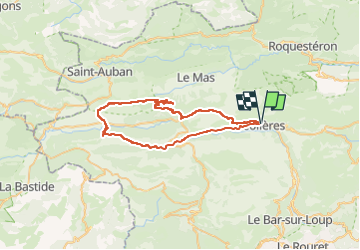
21 km | 31 km-effort
7h 20min
![](https://static1.geolcdn.com/siteimages/upload/files/16400158638029165_repeat_loop_refresh_sync_direction_icon.png)
Nein
![Tour Zu Fuß Cipières - Traversée de l'Estéron - Etape 2 - Photo](https://media.geolcdn.com/t/375/260/ebd4d990-1504-43f1-96fb-3c8749b403dd.jpeg&format=jpg&maxdim=2)
![Zu Fuß Zu Fuß](https://static1.geolcdn.com/sitytour/trail-icons/100.png)
Traversée de l'Estéron - Etape 2
Zu Fuß
Schwierig
Cipières,
Provence-Alpes-Côte d'Azur,
Seealpen,
France
![](/images/other/stat-length.png)
21 km | 41 km-effort
9h 18min
![](https://static1.geolcdn.com/siteimages/upload/files/16400158638029165_repeat_loop_refresh_sync_direction_icon.png)
Nein
![Tour Zu Fuß Cipières - Traversée de l'Estéron - Etape 1 - Photo](https://media.geolcdn.com/t/375/260/0e49d622-3c08-45d7-a080-59d63fc9110b.jpeg&format=jpg&maxdim=2)
![Zu Fuß Zu Fuß](https://static1.geolcdn.com/sitytour/trail-icons/100.png)
Traversée de l'Estéron - Etape 1
Zu Fuß
Medium
Cipières,
Provence-Alpes-Côte d'Azur,
Seealpen,
France
![](/images/other/stat-length.png)
18,4 km | 29 km-effort
6h 28min
![](https://static1.geolcdn.com/siteimages/upload/files/16400158638029165_repeat_loop_refresh_sync_direction_icon.png)
Nein
![Tour Zu Fuß Gréolières - Cime du Cheiron - Photo](https://media.geolcdn.com/t/375/260/273aae50-c65a-44a2-8836-25bdf1d17610.jpeg&format=jpg&maxdim=2)
![Zu Fuß Zu Fuß](https://static1.geolcdn.com/sitytour/trail-icons/100.png)
Cime du Cheiron
Zu Fuß
Einfach
Gréolières,
Provence-Alpes-Côte d'Azur,
Seealpen,
France
![](/images/other/stat-length.png)
5,9 km | 8,9 km-effort
2h 1min
![](https://static1.geolcdn.com/siteimages/upload/files/16400158638029165_repeat_loop_refresh_sync_direction_icon.png)
Nein
![Tour Zu Fuß Cipières - Plateau de Calern - Photo](https://media.geolcdn.com/t/375/260/04069cc7-0f77-41ab-bace-443cac173cb2.jpeg&format=jpg&maxdim=2)
![Zu Fuß Zu Fuß](https://static1.geolcdn.com/sitytour/trail-icons/100.png)
Plateau de Calern
Zu Fuß
Medium
Cipières,
Provence-Alpes-Côte d'Azur,
Seealpen,
France
![](/images/other/stat-length.png)
13,5 km | 21 km-effort
4h 44min
![](https://static1.geolcdn.com/siteimages/upload/files/16400158638029165_repeat_loop_refresh_sync_direction_icon.png)
Ja
![Tour Zu Fuß Gréolières - Circuit du Loup - Photo](https://media.geolcdn.com/t/375/260/09dfa2b7-7900-471b-b9af-79ed74d6292b.jpeg&format=jpg&maxdim=2)
![Zu Fuß Zu Fuß](https://static1.geolcdn.com/sitytour/trail-icons/100.png)
Circuit du Loup
Zu Fuß
Einfach
Gréolières,
Provence-Alpes-Côte d'Azur,
Seealpen,
France
![](/images/other/stat-length.png)
6,5 km | 12,7 km-effort
2h 52min
![](https://static1.geolcdn.com/siteimages/upload/files/16400158638029165_repeat_loop_refresh_sync_direction_icon.png)
Ja
![Tour Zu Fuß Gréolières - Traversée des Miroirs - Photo](https://media.geolcdn.com/t/375/260/273aae50-c65a-44a2-8836-25bdf1d17610.jpeg&format=jpg&maxdim=2)
![Zu Fuß Zu Fuß](https://static1.geolcdn.com/sitytour/trail-icons/100.png)
Traversée des Miroirs
Zu Fuß
Einfach
Gréolières,
Provence-Alpes-Côte d'Azur,
Seealpen,
France
![](/images/other/stat-length.png)
6,6 km | 12 km-effort
2h 43min
![](https://static1.geolcdn.com/siteimages/upload/files/16400158638029165_repeat_loop_refresh_sync_direction_icon.png)
Nein
![Tour Wandern Gréolières - Cretes du Cheiron - Photo](https://media.geolcdn.com/t/375/260/88c8f012-b9cc-414c-b278-7a06867d8cc1.jpg&format=jpg&maxdim=2)
![Wandern Wandern](https://static1.geolcdn.com/sitytour/trail-icons/101.png)
Cretes du Cheiron
Wandern
Einfach
Gréolières,
Provence-Alpes-Côte d'Azur,
Seealpen,
France
![](/images/other/stat-length.png)
11,8 km | 18,1 km-effort
5h 5min
![](https://static1.geolcdn.com/siteimages/upload/files/16400158638029165_repeat_loop_refresh_sync_direction_icon.png)
Ja
![Tour Wandern Gréolières - Greolieres au Cheiron - Photo](https://media.geolcdn.com/t/375/260/a795c4bb-6c25-4de9-8cde-b16d0eac6c34.jpg&format=jpg&maxdim=2)
![Wandern Wandern](https://static1.geolcdn.com/sitytour/trail-icons/101.png)
Greolieres au Cheiron
Wandern
Medium
Gréolières,
Provence-Alpes-Côte d'Azur,
Seealpen,
France
![](/images/other/stat-length.png)
12,8 km | 26 km-effort
5h 49min
![](https://static1.geolcdn.com/siteimages/upload/files/16400158638029165_repeat_loop_refresh_sync_direction_icon.png)
Ja