![](/images/other/stat-length.png)
![Tour Wandern Chaumont-Gistoux - #200327 - Gistoux, Babaures, Brûlotte, Crola et Bois Sonnet*** - Photo](https://media.geolcdn.com/t/1900/400/ext.pjpeg?maxdim=2&url=https%3A%2F%2Fstatic1.geolcdn.com%2Fsiteimages%2Fupload%2Ffiles%2F1553511878bg_sport_marche.png)
#200327 - Gistoux, Babaures, Brûlotte, Crola et Bois Sonnet***
Randos Ouvertes
Benutzer
![Länge](/images/other/stat-length.png)
Länge
7,1 km
![Maximale Höhe](https://static1.geolcdn.com/siteimages/upload/files/1508320355ic_sort_altitude_max_24dp.png)
Maximale Höhe
138 m
![Positive Höhendifferenz](https://static1.geolcdn.com/siteimages/upload/files/1508320355ic_sort_den_pos_24dp.png)
Positive Höhendifferenz
117 m
![Km-Effort](/images/other/stat-length.png)
Km-Effort
8,6 km
![Min. Höhe](https://static1.geolcdn.com/siteimages/upload/files/1508320355ic_sort_altitude_min_24dp.png)
Min. Höhe
76 m
![Negative Höhendifferenz](https://static1.geolcdn.com/siteimages/upload/files/1508320355ic_sort_den_neg_24dp.png)
Negative Höhendifferenz
119 m
![Boucle](https://static1.geolcdn.com/siteimages/upload/files/16400158638029165_repeat_loop_refresh_sync_direction_icon.png)
Boucle
Ja
Erstellungsdatum :
2023-05-03 13:06:22.343
Letzte Änderung :
2023-05-03 13:10:02.032
![Wandern](https://static1.geolcdn.com/sitytour/trail-icons/101.png)
1h57
Schwierigkeit : Medium
![Scannen Sie diesen QR-Code, um die Tour in der SityTrail-Anwendung zu öffnen](https://capi.geolives.com/qq0zvz2zws4bq2lad0pu/sitytour/trails/3645340/qr.png?size=200)
Kostenlosegpshiking-Anwendung
Über SityTrail
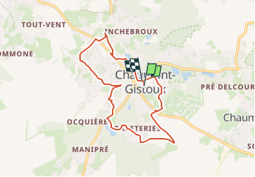
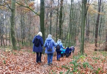
Tour Wandern von 7,1 km verfügbar auf Wallonien, Wallonisch-Brabant, Chaumont-Gistoux. Diese Tour wird von Randos Ouvertes vorgeschlagen.
Beschreibung
très belle balade autour de Gistoux, sentiers entre les jardins; Traversée champ du Crola à vos risques et périls, présence de bétail possible, faire demi-tour si vous ne le sentez pas ou si le taureau est présent.
POIs
Ort
Land:
Belgium
Region :
Wallonien
Abteilung/Provinz :
Wallonisch-Brabant
Kommune :
Chaumont-Gistoux
Standort:
Unknown
Gehen Sie:(Dec)
Gehen Sie:(UTM)
619899 ; 5615985 (31U) N.
Kommentare
Touren in der Umgebung
![Tour Wandern Chaumont-Gistoux - De Dion-le Mont à Dion-le Val par la vallée du Pisselet - Photo](https://media.geolcdn.com/t/375/260/ext.jpg?maxdim=2&url=https%3A%2F%2Fstatic1.geolcdn.com%2Fsiteimages%2Fupload%2Ffiles%2F1553511878bg_sport_marche.png)
![Wandern Wandern](https://static1.geolcdn.com/sitytour/trail-icons/101.png)
De Dion-le Mont à Dion-le Val par la vallée du Pisselet
Wandern
Sehr leicht
(8)
Chaumont-Gistoux,
Wallonien,
Wallonisch-Brabant,
Belgium
![](/images/other/stat-length.png)
8,6 km | 10,3 km-effort
2h 0min
![](https://static1.geolcdn.com/siteimages/upload/files/16400158638029165_repeat_loop_refresh_sync_direction_icon.png)
Ja
![Wandern Wandern](https://static1.geolcdn.com/sitytour/trail-icons/101.png)
#240301 - Ocquière
Wandern
Medium
(1)
Chaumont-Gistoux,
Wallonien,
Wallonisch-Brabant,
Belgium
![](/images/other/stat-length.png)
5,2 km | 6,2 km-effort
1h 24min
![](https://static1.geolcdn.com/siteimages/upload/files/16400158638029165_repeat_loop_refresh_sync_direction_icon.png)
Ja
![Tour Wandern Chaumont-Gistoux - #231016 - Corroy-Le-Grand et le Val d'Ocquière*** (inversé court) - Photo](https://media.geolcdn.com/t/375/260/b650de28-d96e-49f2-85c2-d640aecfc352.jpg&format=jpg&maxdim=2)
![Wandern Wandern](https://static1.geolcdn.com/sitytour/trail-icons/101.png)
#231016 - Corroy-Le-Grand et le Val d'Ocquière*** (inversé court)
Wandern
Medium
(2)
Chaumont-Gistoux,
Wallonien,
Wallonisch-Brabant,
Belgium
![](/images/other/stat-length.png)
6,2 km | 7,2 km-effort
1h 38min
![](https://static1.geolcdn.com/siteimages/upload/files/16400158638029165_repeat_loop_refresh_sync_direction_icon.png)
Ja
![Wandern Wandern](https://static1.geolcdn.com/sitytour/trail-icons/101.png)
#210507 Dion-le-Mont, Pisselet et Louvranges
Wandern
Medium
(1)
Chaumont-Gistoux,
Wallonien,
Wallonisch-Brabant,
Belgium
![](/images/other/stat-length.png)
6,5 km | 7,9 km-effort
2h 12min
![](https://static1.geolcdn.com/siteimages/upload/files/16400158638029165_repeat_loop_refresh_sync_direction_icon.png)
Ja
![Wandern Wandern](https://static1.geolcdn.com/sitytour/trail-icons/101.png)
#210427 - Longueville, Hèze et Petit Hacquedeau
Wandern
Medium
(1)
Chaumont-Gistoux,
Wallonien,
Wallonisch-Brabant,
Belgium
![](/images/other/stat-length.png)
8 km | 9,2 km-effort
2h 5min
![](https://static1.geolcdn.com/siteimages/upload/files/16400158638029165_repeat_loop_refresh_sync_direction_icon.png)
Ja
![Zu Fuß Zu Fuß](https://static1.geolcdn.com/sitytour/trail-icons/100.png)
#181126 - Bonlez, Bois et réserve naturelle de l'Étoile ***
Zu Fuß
Einfach
(1)
Chaumont-Gistoux,
Wallonien,
Wallonisch-Brabant,
Belgium
![](/images/other/stat-length.png)
8,4 km | 10,6 km-effort
2h 10min
![](https://static1.geolcdn.com/siteimages/upload/files/16400158638029165_repeat_loop_refresh_sync_direction_icon.png)
Ja
![Zu Fuß Zu Fuß](https://static1.geolcdn.com/sitytour/trail-icons/100.png)
#181130 - Autour de Vieusart, version courte
Zu Fuß
Einfach
(2)
Chaumont-Gistoux,
Wallonien,
Wallonisch-Brabant,
Belgium
![](/images/other/stat-length.png)
7,7 km | 9,3 km-effort
2h 0min
![](https://static1.geolcdn.com/siteimages/upload/files/16400158638029165_repeat_loop_refresh_sync_direction_icon.png)
Ja
![Tour Wandern Chaumont-Gistoux - Gistoux 19 12 2017 Nathalie Demain - Photo](https://media.geolcdn.com/t/375/260/ext.jpg?maxdim=2&url=https%3A%2F%2Fservices.sitytrail.com%2FGeolivesWS%2FDownloadMedia.ashx%3FTrailID%3D877395%26Media%3Dfix__20171219153407.jpg)
![Wandern Wandern](https://static1.geolcdn.com/sitytour/trail-icons/101.png)
Gistoux 19 12 2017 Nathalie Demain
Wandern
Einfach
(1)
Chaumont-Gistoux,
Wallonien,
Wallonisch-Brabant,
Belgium
![](/images/other/stat-length.png)
14,6 km | 17,1 km-effort
5h 28min
![](https://static1.geolcdn.com/siteimages/upload/files/16400158638029165_repeat_loop_refresh_sync_direction_icon.png)
Ja
![Tour Wandern Chaumont-Gistoux - La vallée du Train - Photo](https://media.geolcdn.com/t/375/260/ext.jpg?maxdim=2&url=https%3A%2F%2Fservices.sitytrail.com%2FGeolivesWS%2FDownloadMedia.ashx%3FTrailID%3D207877%26Media%3D689faf6a-f3e8-4f6c-a4c5-266f2fae9da7.jpg)
![Wandern Wandern](https://static1.geolcdn.com/sitytour/trail-icons/101.png)
La vallée du Train
Wandern
Einfach
(1)
Chaumont-Gistoux,
Wallonien,
Wallonisch-Brabant,
Belgium
![](/images/other/stat-length.png)
9 km | 11,1 km-effort
2h 24min
![](https://static1.geolcdn.com/siteimages/upload/files/16400158638029165_repeat_loop_refresh_sync_direction_icon.png)
Nein