![](/images/other/stat-length.png)
![Tour Zu Fuß Fuldatal - Heidelbeerweg - Photo](https://media.geolcdn.com/t/1900/400/07eb5110-d3ab-4809-ba0b-3760dc840177.jpeg&format=pjpeg&maxdim=2)
Heidelbeerweg
SityTrail - itinéraires balisés pédestres
Tous les sentiers balisés d’Europe GUIDE+
![Länge](/images/other/stat-length.png)
Länge
6,7 km
![Maximale Höhe](https://static1.geolcdn.com/siteimages/upload/files/1508320355ic_sort_altitude_max_24dp.png)
Maximale Höhe
388 m
![Positive Höhendifferenz](https://static1.geolcdn.com/siteimages/upload/files/1508320355ic_sort_den_pos_24dp.png)
Positive Höhendifferenz
260 m
![Km-Effort](/images/other/stat-length.png)
Km-Effort
9,4 km
![Min. Höhe](https://static1.geolcdn.com/siteimages/upload/files/1508320355ic_sort_altitude_min_24dp.png)
Min. Höhe
141 m
![Negative Höhendifferenz](https://static1.geolcdn.com/siteimages/upload/files/1508320355ic_sort_den_neg_24dp.png)
Negative Höhendifferenz
16 m
![Boucle](https://static1.geolcdn.com/siteimages/upload/files/16400158638029165_repeat_loop_refresh_sync_direction_icon.png)
Boucle
Nein
Kennzeichnung
Erstellungsdatum :
2022-02-11 15:07:47.78
Letzte Änderung :
2022-02-11 15:07:47.78
![Zu Fuß](https://static1.geolcdn.com/sitytour/trail-icons/100.png)
2h08
Schwierigkeit : Einfach
![Scannen Sie diesen QR-Code, um die Tour in der SityTrail-Anwendung zu öffnen](https://capi.geolives.com/qq0zvz2zws4bq2lad0pu/sitytour/trails/3093882/qr.png?size=200)
Kostenlosegpshiking-Anwendung
Über SityTrail
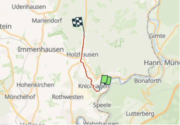
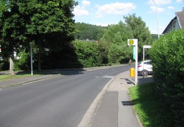
Tour Zu Fuß von 6,7 km verfügbar auf Hessen, Landkreis Kassel, Fuldatal. Diese Tour wird von SityTrail - itinéraires balisés pédestres vorgeschlagen.
Beschreibung
Trail created by Hessisch-Waldeckischer Gebirgs- und Heimatverein (HWGHV).
Website: https://www.immenhausen.de/index.php?seitenid=80&parent=28&brosis=125&nmon=127
Ort
Land:
Germany
Region :
Hessen
Abteilung/Provinz :
Landkreis Kassel
Kommune :
Fuldatal
Standort:
Unknown
Gehen Sie:(Dec)
Gehen Sie:(UTM)
539064 ; 5693519 (32U) N.
Kommentare
Touren in der Umgebung
![Tour Zu Fuß Immenhausen - Eco-Pfad Holzhausen, Kleebergrunde - Photo](https://media.geolcdn.com/t/375/260/7f8db2c5-79ba-4b4d-81e9-dd2242c46273.jpeg&format=jpg&maxdim=2)
![Zu Fuß Zu Fuß](https://static1.geolcdn.com/sitytour/trail-icons/100.png)
Eco-Pfad Holzhausen, Kleebergrunde
Zu Fuß
Einfach
Immenhausen,
Hessen,
Landkreis Kassel,
Germany
![](/images/other/stat-length.png)
4 km | 5 km-effort
1h 7min
![](https://static1.geolcdn.com/siteimages/upload/files/16400158638029165_repeat_loop_refresh_sync_direction_icon.png)
Ja
![Tour Zu Fuß Immenhausen - Eco Pfad Holzhausen, Osterbergrunde - Photo](https://media.geolcdn.com/t/375/260/7f8db2c5-79ba-4b4d-81e9-dd2242c46273.jpeg&format=jpg&maxdim=2)
![Zu Fuß Zu Fuß](https://static1.geolcdn.com/sitytour/trail-icons/100.png)
Eco Pfad Holzhausen, Osterbergrunde
Zu Fuß
Einfach
Immenhausen,
Hessen,
Landkreis Kassel,
Germany
![](/images/other/stat-length.png)
4,7 km | 6,3 km-effort
1h 25min
![](https://static1.geolcdn.com/siteimages/upload/files/16400158638029165_repeat_loop_refresh_sync_direction_icon.png)
Ja
![Tour Zu Fuß Fuldatal - Eco Pfad Knickhagen-Wilhelmshausen - Photo](https://media.geolcdn.com/t/375/260/7cc63fde-47bd-4af1-bf9d-7fed921d3fd8.jpeg&format=jpg&maxdim=2)
![Zu Fuß Zu Fuß](https://static1.geolcdn.com/sitytour/trail-icons/100.png)
Eco Pfad Knickhagen-Wilhelmshausen
Zu Fuß
Einfach
Fuldatal,
Hessen,
Landkreis Kassel,
Germany
![](/images/other/stat-length.png)
8 km | 10,1 km-effort
2h 17min
![](https://static1.geolcdn.com/siteimages/upload/files/16400158638029165_repeat_loop_refresh_sync_direction_icon.png)
Ja
![Tour Zu Fuß Fuldatal - Eco-Pfad Simmershausen - Photo](https://media.geolcdn.com/t/375/260/97564b49-06cf-4a5a-839c-e9bf51b9936e.jpeg&format=jpg&maxdim=2)
![Zu Fuß Zu Fuß](https://static1.geolcdn.com/sitytour/trail-icons/100.png)
Eco-Pfad Simmershausen
Zu Fuß
Einfach
Fuldatal,
Hessen,
Landkreis Kassel,
Germany
![](/images/other/stat-length.png)
6,6 km | 8,1 km-effort
1h 50min
![](https://static1.geolcdn.com/siteimages/upload/files/16400158638029165_repeat_loop_refresh_sync_direction_icon.png)
Ja
![Tour Zu Fuß Fuldatal - Steinköhlerpfad - Photo](https://media.geolcdn.com/t/375/260/00273cb5-fcd0-4396-93ac-dafb194708d7.jpeg&format=jpg&maxdim=2)
![Zu Fuß Zu Fuß](https://static1.geolcdn.com/sitytour/trail-icons/100.png)
Steinköhlerpfad
Zu Fuß
Einfach
Fuldatal,
Hessen,
Landkreis Kassel,
Germany
![](/images/other/stat-length.png)
5,4 km | 8,3 km-effort
1h 53min
![](https://static1.geolcdn.com/siteimages/upload/files/16400158638029165_repeat_loop_refresh_sync_direction_icon.png)
Nein
![Tour Zu Fuß Fuldatal - Historischer Kirchweg - Photo](https://media.geolcdn.com/t/375/260/4e8a90e0-d9d2-4105-bfad-a987424fb579.jpeg&format=jpg&maxdim=2)
![Zu Fuß Zu Fuß](https://static1.geolcdn.com/sitytour/trail-icons/100.png)
Historischer Kirchweg
Zu Fuß
Einfach
Fuldatal,
Hessen,
Landkreis Kassel,
Germany
![](/images/other/stat-length.png)
3,7 km | 4,3 km-effort
58min
![](https://static1.geolcdn.com/siteimages/upload/files/16400158638029165_repeat_loop_refresh_sync_direction_icon.png)
Nein
![Tour Zu Fuß Gutsbezirk Reinhardswald - Fuldatal-Wilhelmshausen, Rundweg 2 - Photo](https://media.geolcdn.com/t/375/260/d191a0c8-98f0-41fd-baa7-2e032b85b321.jpeg&format=jpg&maxdim=2)
![Zu Fuß Zu Fuß](https://static1.geolcdn.com/sitytour/trail-icons/100.png)
Fuldatal-Wilhelmshausen, Rundweg 2
Zu Fuß
Einfach
Gutsbezirk Reinhardswald,
Hessen,
Landkreis Kassel,
Germany
![](/images/other/stat-length.png)
5,4 km | 7,5 km-effort
1h 42min
![](https://static1.geolcdn.com/siteimages/upload/files/16400158638029165_repeat_loop_refresh_sync_direction_icon.png)
Ja
![Tour Zu Fuß Fuldatal - Fuldatal-Simmershausen, Rundweg 2 - Photo](https://media.geolcdn.com/t/375/260/3d0938c8-0337-47de-8775-5d4785076cde.jpeg&format=jpg&maxdim=2)
![Zu Fuß Zu Fuß](https://static1.geolcdn.com/sitytour/trail-icons/100.png)
Fuldatal-Simmershausen, Rundweg 2
Zu Fuß
Einfach
Fuldatal,
Hessen,
Landkreis Kassel,
Germany
![](/images/other/stat-length.png)
3,8 km | 4,6 km-effort
1h 2min
![](https://static1.geolcdn.com/siteimages/upload/files/16400158638029165_repeat_loop_refresh_sync_direction_icon.png)
Ja
![Tour Zu Fuß Fuldatal - Fuldatal-Knickhagen, Rundweg 3 - Photo](https://media.geolcdn.com/t/375/260/ext.jpg?maxdim=2&url=https%3A%2F%2Fstatic1.geolcdn.com%2Fsiteimages%2Fupload%2Ffiles%2F1545311037marcheuse_200dpi.jpg)
![Zu Fuß Zu Fuß](https://static1.geolcdn.com/sitytour/trail-icons/100.png)
Fuldatal-Knickhagen, Rundweg 3
Zu Fuß
Einfach
Fuldatal,
Hessen,
Landkreis Kassel,
Germany
![](/images/other/stat-length.png)
3,6 km | 4,8 km-effort
1h 5min
![](https://static1.geolcdn.com/siteimages/upload/files/16400158638029165_repeat_loop_refresh_sync_direction_icon.png)
Ja