![](/images/other/stat-length.png)
![Tour Wandern Urdos - Lac d'Estaens et environs - Photo](https://media.geolcdn.com/t/1900/400/795b0e28-1fa9-4eb7-baf6-c4a84979127a.jpg&format=pjpeg&maxdim=2)
Lac d'Estaens et environs
bedous
Benutzer
![Länge](/images/other/stat-length.png)
![Maximale Höhe](https://static1.geolcdn.com/siteimages/upload/files/1508320355ic_sort_altitude_max_24dp.png)
![Positive Höhendifferenz](https://static1.geolcdn.com/siteimages/upload/files/1508320355ic_sort_den_pos_24dp.png)
![Km-Effort](/images/other/stat-length.png)
![Min. Höhe](https://static1.geolcdn.com/siteimages/upload/files/1508320355ic_sort_altitude_min_24dp.png)
![Negative Höhendifferenz](https://static1.geolcdn.com/siteimages/upload/files/1508320355ic_sort_den_neg_24dp.png)
![Boucle](https://static1.geolcdn.com/siteimages/upload/files/16400158638029165_repeat_loop_refresh_sync_direction_icon.png)
![Wandern](https://static1.geolcdn.com/sitytour/trail-icons/101.png)
7h42
Schwierigkeit : Schwierig
![Scannen Sie diesen QR-Code, um die Tour in der SityTrail-Anwendung zu öffnen](https://capi.geolives.com/qq0zvz2zws4bq2lad0pu/sitytour/trails/2447695/qr.png?size=200)
Kostenlosegpshiking-Anwendung
Über SityTrail
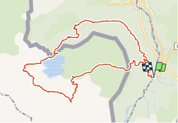
Tour Wandern von 14,9 km verfügbar auf Neu-Aquitanien, Pyrenäen-Atlantik, Urdos. Diese Tour wird von bedous vorgeschlagen.
Beschreibung
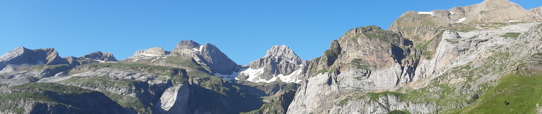
Vallée d'Aspe. Urdos. Somport. Espagne.
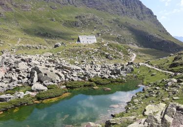
Rando avec des pentes "raisonnables". Tour du lac permettant de déjeuner facilement. Les braves se baignent. Sur le sud du parcours nous traversons une zone de paturages. Y voir une cascade magnifique à l'intérieur des roches et plus loin l'eau s'engouffrée dans un puit. Au nord du parcours après le passage de l'échelle le chemin s'effectue en grande partie sous ombrage.
Ort
Kommentare
Touren in der Umgebung
![Tour Zu Fuß Urdos - Sentier de Peyranère au Refuge de Larry PNP - Photo](https://media.geolcdn.com/t/375/260/12d86d0c-9ae8-4a0a-b713-61ee3738bf3b.jpeg&format=jpg&maxdim=2)
![Zu Fuß Zu Fuß](https://static1.geolcdn.com/sitytour/trail-icons/100.png)
Zu Fuß
![](/images/other/stat-length.png)
![](https://static1.geolcdn.com/siteimages/upload/files/16400158638029165_repeat_loop_refresh_sync_direction_icon.png)
![Tour Zu Fuß Urdos - Sentier du Plateau de la Gentiane PNP - Photo](https://media.geolcdn.com/t/375/260/12d86d0c-9ae8-4a0a-b713-61ee3738bf3b.jpeg&format=jpg&maxdim=2)
![Zu Fuß Zu Fuß](https://static1.geolcdn.com/sitytour/trail-icons/100.png)
Zu Fuß
![](/images/other/stat-length.png)
![](https://static1.geolcdn.com/siteimages/upload/files/16400158638029165_repeat_loop_refresh_sync_direction_icon.png)
![Tour Zu Fuß Urdos - Sentier du Lac d'Estaëns PNP - Photo](https://media.geolcdn.com/t/375/260/f2b54571-15e4-4669-844e-6d4a7160a93e.jpeg&format=jpg&maxdim=2)
![Zu Fuß Zu Fuß](https://static1.geolcdn.com/sitytour/trail-icons/100.png)
Zu Fuß
![](/images/other/stat-length.png)
![](https://static1.geolcdn.com/siteimages/upload/files/16400158638029165_repeat_loop_refresh_sync_direction_icon.png)
![Tour Wandern Borce - Boucle Lescun 4J - E4 - Photo](https://media.geolcdn.com/t/375/260/ext.jpg?maxdim=2&url=https%3A%2F%2Fstatic1.geolcdn.com%2Fsiteimages%2Fupload%2Ffiles%2F1553511878bg_sport_marche.png)
![Wandern Wandern](https://static1.geolcdn.com/sitytour/trail-icons/101.png)
Wandern
![](/images/other/stat-length.png)
![](https://static1.geolcdn.com/siteimages/upload/files/16400158638029165_repeat_loop_refresh_sync_direction_icon.png)
![Tour Wandern Borce - hrp Arlet to candanchu - Photo](https://media.geolcdn.com/t/375/260/ext.jpg?maxdim=2&url=https%3A%2F%2Fstatic1.geolcdn.com%2Fsiteimages%2Fupload%2Ffiles%2F1553511878bg_sport_marche.png)
![Wandern Wandern](https://static1.geolcdn.com/sitytour/trail-icons/101.png)
Wandern
![](/images/other/stat-length.png)
![](https://static1.geolcdn.com/siteimages/upload/files/16400158638029165_repeat_loop_refresh_sync_direction_icon.png)
![Tour Wandern Borce - Chemin de l'escalé - Photo](https://media.geolcdn.com/t/375/260/a66f4049-6310-4965-a5bd-700ca57594e4.jpg&format=jpg&maxdim=2)
![Wandern Wandern](https://static1.geolcdn.com/sitytour/trail-icons/101.png)
Wandern
![](/images/other/stat-length.png)
![](https://static1.geolcdn.com/siteimages/upload/files/16400158638029165_repeat_loop_refresh_sync_direction_icon.png)
![Tour Wandern Borce - Lac d'Estaens - Photo](https://media.geolcdn.com/t/375/260/1c0d5bd9-b4bf-4d4c-82d2-78a185a6a0dd.jpg&format=jpg&maxdim=2)
![Wandern Wandern](https://static1.geolcdn.com/sitytour/trail-icons/101.png)
Wandern
![](/images/other/stat-length.png)
![](https://static1.geolcdn.com/siteimages/upload/files/16400158638029165_repeat_loop_refresh_sync_direction_icon.png)
![Tour Wandern Urdos - Plateau de la gentiane - Photo](https://media.geolcdn.com/t/375/260/b1985722-4b53-4d00-9ae9-e27a98bdc95b.jpg&format=jpg&maxdim=2)
![Wandern Wandern](https://static1.geolcdn.com/sitytour/trail-icons/101.png)
Wandern
![](/images/other/stat-length.png)
![](https://static1.geolcdn.com/siteimages/upload/files/16400158638029165_repeat_loop_refresh_sync_direction_icon.png)
![Tour Wandern Jaca - Astun au refuge d'Ayous - Photo](https://media.geolcdn.com/t/375/260/1e39d533-c1e5-4cdf-a56c-0d6ddac15124.jpg&format=jpg&maxdim=2)
![Wandern Wandern](https://static1.geolcdn.com/sitytour/trail-icons/101.png)
Wandern
![](/images/other/stat-length.png)
![](https://static1.geolcdn.com/siteimages/upload/files/16400158638029165_repeat_loop_refresh_sync_direction_icon.png)