![](/images/other/stat-length.png)
![Tour Wandern Lasne - RB-Bw-11 - Raccourci 1 - Les cinq clochers de Lasne - Photo](https://media.geolcdn.com/t/1900/400/ext.pjpeg?maxdim=2&url=https%3A%2F%2Fservices.sitytrail.com%2FGeolivesWS%2FDownloadMedia.ashx%3FTrailID%3D220381%26Media%3Dc424c810-e3fc-4417-9a3b-ca0a22b722e1.jpg)
RB-Bw-11 - Raccourci 1 - Les cinq clochers de Lasne
GR Rando
Randonnez sur et autour des GR ® wallons (Sentiers de Grande Randonnée). PRO
![Länge](/images/other/stat-length.png)
![Maximale Höhe](https://static1.geolcdn.com/siteimages/upload/files/1508320355ic_sort_altitude_max_24dp.png)
![Positive Höhendifferenz](https://static1.geolcdn.com/siteimages/upload/files/1508320355ic_sort_den_pos_24dp.png)
![Km-Effort](/images/other/stat-length.png)
![Min. Höhe](https://static1.geolcdn.com/siteimages/upload/files/1508320355ic_sort_altitude_min_24dp.png)
![Negative Höhendifferenz](https://static1.geolcdn.com/siteimages/upload/files/1508320355ic_sort_den_neg_24dp.png)
![Boucle](https://static1.geolcdn.com/siteimages/upload/files/16400158638029165_repeat_loop_refresh_sync_direction_icon.png)
![Wandern](https://static1.geolcdn.com/sitytour/trail-icons/101.png)
5h41
Schwierigkeit : Sehr schwierig
![Scannen Sie diesen QR-Code, um die Tour in der SityTrail-Anwendung zu öffnen](https://capi.geolives.com/qq0zvz2zws4bq2lad0pu/sitytour/trails/220381/qr.png?size=200)
Kostenlosegpshiking-Anwendung
Über SityTrail
Tour Wandern von 20 km verfügbar auf Wallonien, Wallonisch-Brabant, Lasne. Diese Tour wird von GR Rando vorgeschlagen.
Beschreibung
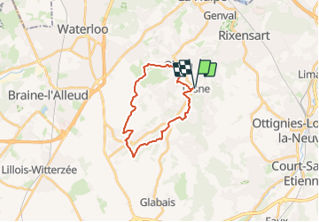
Lasne – Ohain – Plancenoit – Couture-Saint-Germain – Lasne
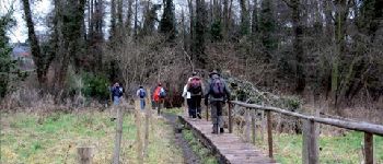
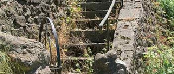
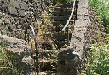
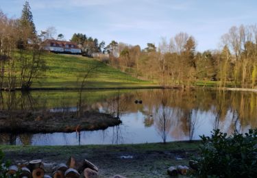
Commune opulente, Lasne est également riche d’un exceptionnel réseau
de chemins et sentiers, tous bien entretenus, rigoureusement répertoriés
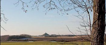
et dotés d’une signalisation irréprochable. Voici donc une balade particulièrement variée, par les cinq villages de l’entité, au coeur de vastes surfaces cultivées et à travers quelques massifs boisés, par des splendides chemins encaissés, des chaussées pavées à l’ancienne,
des venelles minuscules. Surprises garanties ! Et découverte d’un patrimoine culturel remarquable et de sites qui, en juin 1815, virent basculer le sort de l’Europe.
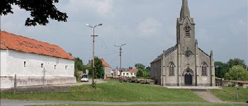
Baigné par la rivière du même nom, le village de Lasne, qui a conservé son nom après la fusion avec quatre autres villages, est une bourgade essentiellement résidentielle et agricole. Elle compte environ 14 000 habitants.
Cartographie et documentation
Carte IGN au 1 :20 000, 39/3-4 « Waterloo – La Hulpe).
Topo-guide du GR 126 « Bruxelles – Namur – Membre-sur-Semois ».
Carte au 1:10 000 « 210 km de promenades balisées à Lasne », accompagnée
d’une brochure, éditée en collaboration avec l’IGN.
Où se désaltérer et se restaurer
À Lasne, en face de l’église, le bistrot-taverne « La Tartine ».
À Plancenoit, le café « Le Gros Vélo », nous a hébergés pour notre pique-nique.
Ort
Kommentare
Touren in der Umgebung
![Tour Wandern Lasne - RB-Bw-11 - Raccourci 2 - Les cinq clochers de Lasne - Photo](https://media.geolcdn.com/t/375/260/ext.jpg?maxdim=2&url=https%3A%2F%2Fservices.sitytrail.com%2FGeolivesWS%2FDownloadMedia.ashx%3FTrailID%3D220382%26Media%3De3749982-4581-4663-b0ab-732ada3b6d18.jpg)
![Wandern Wandern](https://static1.geolcdn.com/sitytour/trail-icons/101.png)
Wandern
![](/images/other/stat-length.png)
![](https://static1.geolcdn.com/siteimages/upload/files/16400158638029165_repeat_loop_refresh_sync_direction_icon.png)
![Tour Wandern Lasne - RB-Bw-11 - Les cinq clochers de Lasne - Photo](https://media.geolcdn.com/t/375/260/ext.jpg?maxdim=2&url=https%3A%2F%2Fservices.sitytrail.com%2FGeolivesWS%2FDownloadMedia.ashx%3FTrailID%3D179586%26Media%3Dc424c810-e3fc-4417-9a3b-ca0a22b722e1.jpg)
![Wandern Wandern](https://static1.geolcdn.com/sitytour/trail-icons/101.png)
Wandern
![](/images/other/stat-length.png)
![](https://static1.geolcdn.com/siteimages/upload/files/16400158638029165_repeat_loop_refresh_sync_direction_icon.png)
![Mountainbike Mountainbike](https://static1.geolcdn.com/sitytour/trail-icons/202.png)
Mountainbike
![](/images/other/stat-length.png)
![](https://static1.geolcdn.com/siteimages/upload/files/16400158638029165_repeat_loop_refresh_sync_direction_icon.png)
![Mountainbike Mountainbike](https://static1.geolcdn.com/sitytour/trail-icons/202.png)
Mountainbike
![](/images/other/stat-length.png)
![](https://static1.geolcdn.com/siteimages/upload/files/16400158638029165_repeat_loop_refresh_sync_direction_icon.png)
![Tour Wandern Rixensart - Balade de Rixensart au lac de Genval - Photo](https://media.geolcdn.com/t/375/260/ext.jpg?maxdim=2&url=https%3A%2F%2Fservices.sitytrail.com%2FGeolivesWS%2FDownloadMedia.ashx%3FTrailID%3D486338%26Media%3D5e34c7a6-42f3-4c4e-bd52-3a98cd84457e.JPG)
![Wandern Wandern](https://static1.geolcdn.com/sitytour/trail-icons/101.png)
Wandern
![](/images/other/stat-length.png)
![](https://static1.geolcdn.com/siteimages/upload/files/16400158638029165_repeat_loop_refresh_sync_direction_icon.png)
![Tour Wandern La Hulpe - La Hulpe - Circuit Natura 2000, des sites qui valent le détour - Bw02 - Photo](https://media.geolcdn.com/t/375/260/7fa79586-43de-4fc0-89c7-4bc45138438a.jpg&format=jpg&maxdim=2)
![Wandern Wandern](https://static1.geolcdn.com/sitytour/trail-icons/101.png)
Wandern
![](/images/other/stat-length.png)
![](https://static1.geolcdn.com/siteimages/upload/files/16400158638029165_repeat_loop_refresh_sync_direction_icon.png)
![Wandern Wandern](https://static1.geolcdn.com/sitytour/trail-icons/101.png)
Wandern
![](/images/other/stat-length.png)
![](https://static1.geolcdn.com/siteimages/upload/files/16400158638029165_repeat_loop_refresh_sync_direction_icon.png)
![Wandern Wandern](https://static1.geolcdn.com/sitytour/trail-icons/101.png)
Wandern
![](/images/other/stat-length.png)
![](https://static1.geolcdn.com/siteimages/upload/files/16400158638029165_repeat_loop_refresh_sync_direction_icon.png)
![Tour Wandern La Hulpe - Genval 0222 - Photo](https://media.geolcdn.com/t/375/260/ce137dda-b7be-44e8-80c8-fd5c067d3d98.jpg&format=jpg&maxdim=2)
![Wandern Wandern](https://static1.geolcdn.com/sitytour/trail-icons/101.png)
Wandern
![](/images/other/stat-length.png)
![](https://static1.geolcdn.com/siteimages/upload/files/16400158638029165_repeat_loop_refresh_sync_direction_icon.png)
Jolie 18 km. Beaux paysages. Assez variés. Attention aux battues de chasses dans 2 bois. Il peut y avoir bcp de bout
Très diversifiée, champs, bois, un peu d’asphalte. Très chouette.