![](/images/other/stat-length.png)
![Tour Wandern Colmars - Lacs de Lignin - Photo](https://media.geolcdn.com/t/1900/400/ext.pjpeg?maxdim=2&url=https%3A%2F%2Fstatic1.geolcdn.com%2Fsiteimages%2Fupload%2Ffiles%2F1553511878bg_sport_marche.png)
Lacs de Lignin
jmheydorff
Benutzer
![Länge](/images/other/stat-length.png)
![Maximale Höhe](https://static1.geolcdn.com/siteimages/upload/files/1508320355ic_sort_altitude_max_24dp.png)
![Positive Höhendifferenz](https://static1.geolcdn.com/siteimages/upload/files/1508320355ic_sort_den_pos_24dp.png)
![Km-Effort](/images/other/stat-length.png)
![Min. Höhe](https://static1.geolcdn.com/siteimages/upload/files/1508320355ic_sort_altitude_min_24dp.png)
![Negative Höhendifferenz](https://static1.geolcdn.com/siteimages/upload/files/1508320355ic_sort_den_neg_24dp.png)
![Boucle](https://static1.geolcdn.com/siteimages/upload/files/16400158638029165_repeat_loop_refresh_sync_direction_icon.png)
![Wandern](https://static1.geolcdn.com/sitytour/trail-icons/101.png)
6h00
Schwierigkeit : Medium
![Scannen Sie diesen QR-Code, um die Tour in der SityTrail-Anwendung zu öffnen](https://capi.geolives.com/qq0zvz2zws4bq2lad0pu/sitytour/trails/192078/qr.png?size=200)
Kostenlosegpshiking-Anwendung
Über SityTrail
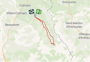
Tour Wandern von 17,6 km verfügbar auf Provence-Alpes-Côte d'Azur, Alpes-de-Haute-Provence, Colmars. Diese Tour wird von jmheydorff vorgeschlagen.
Beschreibung
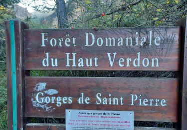
Depuis Colmars,Sud sur RD 908; à 800m, prendre piste goudronnée vers La Buissière,puis continuer en montant une piste forestière, jusqu'au Pkg (alt.1633m) au bord de la lance, 4 kms après la D 908.
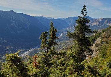
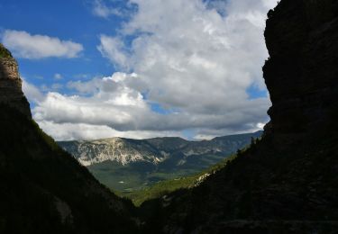
Voir d'abord la cascade en dessous du Pkg, puis monter le ruisseau de la Lance en rive droite, en passant par le hameau du Pont de La serre (2° pkg possible).
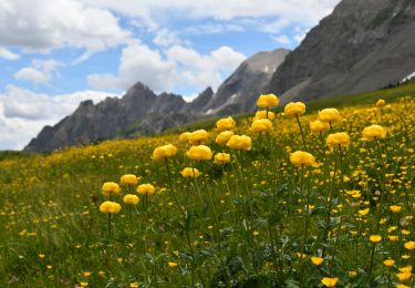
jusqu'aux lacs de Lignin (alt.2273 m).
revenir par la rive gauche de la Lance, en suivant le ruisseau, ou en passant par le haut des falaises (H 200m), sous le sommet de La Mole et du petit Coyer.
Ort
Kommentare
Touren in der Umgebung
![Tour Wandern Thorame-Haute - VILLARS HEYSIER .CABAN DE CONGERMAN - Photo](https://media.geolcdn.com/t/375/260/b251cad8-70ae-4895-901b-fe937d4b0df0.jpg&format=jpg&maxdim=2)
![Wandern Wandern](https://static1.geolcdn.com/sitytour/trail-icons/101.png)
Wandern
![](/images/other/stat-length.png)
![](https://static1.geolcdn.com/siteimages/upload/files/16400158638029165_repeat_loop_refresh_sync_direction_icon.png)
![Tour Wandern Beauvezer - 04.gorges st pierre 03.08.23 - Photo](https://media.geolcdn.com/t/375/260/ee41afb8-8bbb-46c3-8271-84bbc995eeab.jpg&format=jpg&maxdim=2)
![Wandern Wandern](https://static1.geolcdn.com/sitytour/trail-icons/101.png)
Wandern
![](/images/other/stat-length.png)
![](https://static1.geolcdn.com/siteimages/upload/files/16400158638029165_repeat_loop_refresh_sync_direction_icon.png)
![Tour Wandern Colmars - Les lacs Lignin - Photo](https://media.geolcdn.com/t/375/260/fbca6767-bae4-46df-a02f-745bbf118b44.jpg&format=jpg&maxdim=2)
![Wandern Wandern](https://static1.geolcdn.com/sitytour/trail-icons/101.png)
Wandern
![](/images/other/stat-length.png)
![](https://static1.geolcdn.com/siteimages/upload/files/16400158638029165_repeat_loop_refresh_sync_direction_icon.png)
![Tour Wandern Beauvezer - les gorges de St-Pierre - Photo](https://media.geolcdn.com/t/375/260/ext.jpg?maxdim=2&url=https%3A%2F%2Fservices.sitytrail.com%2FGeolivesWS%2FDownloadMedia.ashx%3FTrailID%3D793443%26Media%3Dfix__20170721123335.jpg)
![Wandern Wandern](https://static1.geolcdn.com/sitytour/trail-icons/101.png)
Wandern
![](/images/other/stat-length.png)
![](https://static1.geolcdn.com/siteimages/upload/files/16400158638029165_repeat_loop_refresh_sync_direction_icon.png)
![Tour Wandern Beauvezer - VILLARS HEYSSIER . GORGES DE SAINT PIERRE O - Photo](https://media.geolcdn.com/t/375/260/1711233c-dcfe-4507-8abf-7d44d68d7751.jpg&format=jpg&maxdim=2)
![Wandern Wandern](https://static1.geolcdn.com/sitytour/trail-icons/101.png)
Wandern
![](/images/other/stat-length.png)
![](https://static1.geolcdn.com/siteimages/upload/files/16400158638029165_repeat_loop_refresh_sync_direction_icon.png)
![Tour Wandern Colmars - Colmars petit coyer 993m 14kms - Photo](https://media.geolcdn.com/t/375/260/34cedc48-3841-4962-bcc9-facfdb32c9cc.jpg&format=jpg&maxdim=2)
![Wandern Wandern](https://static1.geolcdn.com/sitytour/trail-icons/101.png)
Wandern
![](/images/other/stat-length.png)
![](https://static1.geolcdn.com/siteimages/upload/files/16400158638029165_repeat_loop_refresh_sync_direction_icon.png)
![Tour Wandern Colmars - Colmars autapie 19.5k ms 1200m - Photo](https://media.geolcdn.com/t/375/260/9d112094-8159-4db6-8f08-1f5a21c98a9f.jpg&format=jpg&maxdim=2)
![Wandern Wandern](https://static1.geolcdn.com/sitytour/trail-icons/101.png)
Wandern
![](/images/other/stat-length.png)
![](https://static1.geolcdn.com/siteimages/upload/files/16400158638029165_repeat_loop_refresh_sync_direction_icon.png)
![Wandern Wandern](https://static1.geolcdn.com/sitytour/trail-icons/101.png)
Wandern
![](/images/other/stat-length.png)
![](https://static1.geolcdn.com/siteimages/upload/files/16400158638029165_repeat_loop_refresh_sync_direction_icon.png)
![Wandern Wandern](https://static1.geolcdn.com/sitytour/trail-icons/101.png)
Wandern
![](/images/other/stat-length.png)
![](https://static1.geolcdn.com/siteimages/upload/files/16400158638029165_repeat_loop_refresh_sync_direction_icon.png)