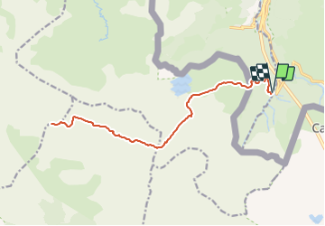
![](/images/other/stat-length.png)
![Tour Wandern Urdos - Le Visaurin 2669m par le lac d'Estaens - Photo](https://media.geolcdn.com/t/1900/400/ext.pjpeg?maxdim=2&url=https%3A%2F%2Fservices.sitytrail.com%2FGeolivesWS%2FDownloadMedia.ashx%3FTrailID%3D109848%26Media%3D4819_1.jpg)
Le Visaurin 2669m par le lac d'Estaens
tracegps
Benutzer
![Länge](/images/other/stat-length.png)
![Maximale Höhe](https://static1.geolcdn.com/siteimages/upload/files/1508320355ic_sort_altitude_max_24dp.png)
![Positive Höhendifferenz](https://static1.geolcdn.com/siteimages/upload/files/1508320355ic_sort_den_pos_24dp.png)
![Km-Effort](/images/other/stat-length.png)
![Min. Höhe](https://static1.geolcdn.com/siteimages/upload/files/1508320355ic_sort_altitude_min_24dp.png)
![Negative Höhendifferenz](https://static1.geolcdn.com/siteimages/upload/files/1508320355ic_sort_den_neg_24dp.png)
![Boucle](https://static1.geolcdn.com/siteimages/upload/files/16400158638029165_repeat_loop_refresh_sync_direction_icon.png)
![Wandern](https://static1.geolcdn.com/sitytour/trail-icons/101.png)
9h00
Schwierigkeit : Schwierig
![Scannen Sie diesen QR-Code, um die Tour in der SityTrail-Anwendung zu öffnen](https://capi.geolives.com/qq0zvz2zws4bq2lad0pu/sitytour/trails/109848/qr.png?size=200)
Kostenlosegpshiking-Anwendung
Über SityTrail
Tour Wandern von 21 km verfügbar auf Neu-Aquitanien, Pyrenäen-Atlantik, Urdos. Diese Tour wird von tracegps vorgeschlagen.
Beschreibung
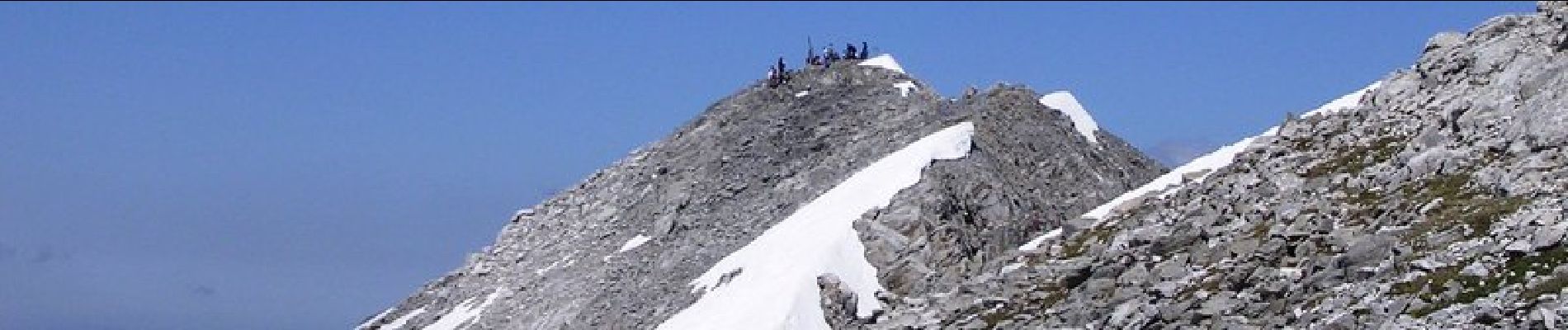
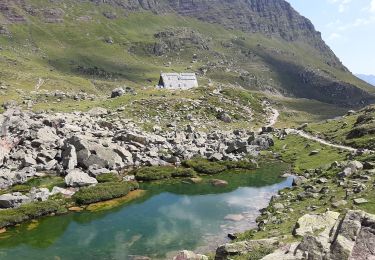
Le Visaurin 2669m par le lac d'Estaens depuis le parking de Sansanet (1320m) Sur le Méridien de Lescun mais totalement en Espagne, six km au Sud de la frontière, le Visaurin est le plus haut sommet entre l'Atlantique et le massif de l'Ossau. Il domine une région extraordinaire, essentiellement calcaire mais présentant des roches d'un rouge surprenant. Son panorama, immense, est l'un des plus insolites de toute la chaîne. L'accès depuis Sansanet est certes long mais facile, et varié: maints endroits splendides constituent à eux seuls des buts de balades, c'est le cas de la vallée de los Sarios qui rappelle des paysages de Westerns ! D’autres indications, photos et panoramiques sur le site « Les Pyrénées vues par Mariano ».
Ort
Kommentare
Touren in der Umgebung
![Tour Zu Fuß Urdos - Sentier de Peyranère au Refuge de Larry PNP - Photo](https://media.geolcdn.com/t/375/260/12d86d0c-9ae8-4a0a-b713-61ee3738bf3b.jpeg&format=jpg&maxdim=2)
![Zu Fuß Zu Fuß](https://static1.geolcdn.com/sitytour/trail-icons/100.png)
Zu Fuß
![](/images/other/stat-length.png)
![](https://static1.geolcdn.com/siteimages/upload/files/16400158638029165_repeat_loop_refresh_sync_direction_icon.png)
![Tour Zu Fuß Urdos - Sentier du Plateau de la Gentiane PNP - Photo](https://media.geolcdn.com/t/375/260/12d86d0c-9ae8-4a0a-b713-61ee3738bf3b.jpeg&format=jpg&maxdim=2)
![Zu Fuß Zu Fuß](https://static1.geolcdn.com/sitytour/trail-icons/100.png)
Zu Fuß
![](/images/other/stat-length.png)
![](https://static1.geolcdn.com/siteimages/upload/files/16400158638029165_repeat_loop_refresh_sync_direction_icon.png)
![Tour Zu Fuß Urdos - Sentier du Lac d'Estaëns PNP - Photo](https://media.geolcdn.com/t/375/260/f2b54571-15e4-4669-844e-6d4a7160a93e.jpeg&format=jpg&maxdim=2)
![Zu Fuß Zu Fuß](https://static1.geolcdn.com/sitytour/trail-icons/100.png)
Zu Fuß
![](/images/other/stat-length.png)
![](https://static1.geolcdn.com/siteimages/upload/files/16400158638029165_repeat_loop_refresh_sync_direction_icon.png)
![Tour Wandern Borce - Boucle Lescun 4J - E4 - Photo](https://media.geolcdn.com/t/375/260/ext.jpg?maxdim=2&url=https%3A%2F%2Fstatic1.geolcdn.com%2Fsiteimages%2Fupload%2Ffiles%2F1553511878bg_sport_marche.png)
![Wandern Wandern](https://static1.geolcdn.com/sitytour/trail-icons/101.png)
Wandern
![](/images/other/stat-length.png)
![](https://static1.geolcdn.com/siteimages/upload/files/16400158638029165_repeat_loop_refresh_sync_direction_icon.png)
![Tour Wandern Borce - hrp Arlet to candanchu - Photo](https://media.geolcdn.com/t/375/260/ext.jpg?maxdim=2&url=https%3A%2F%2Fstatic1.geolcdn.com%2Fsiteimages%2Fupload%2Ffiles%2F1553511878bg_sport_marche.png)
![Wandern Wandern](https://static1.geolcdn.com/sitytour/trail-icons/101.png)
Wandern
![](/images/other/stat-length.png)
![](https://static1.geolcdn.com/siteimages/upload/files/16400158638029165_repeat_loop_refresh_sync_direction_icon.png)
![Tour Wandern Borce - Chemin de l'escalé - Photo](https://media.geolcdn.com/t/375/260/a66f4049-6310-4965-a5bd-700ca57594e4.jpg&format=jpg&maxdim=2)
![Wandern Wandern](https://static1.geolcdn.com/sitytour/trail-icons/101.png)
Wandern
![](/images/other/stat-length.png)
![](https://static1.geolcdn.com/siteimages/upload/files/16400158638029165_repeat_loop_refresh_sync_direction_icon.png)
![Tour Wandern Borce - Lac d'Estaens - Photo](https://media.geolcdn.com/t/375/260/1c0d5bd9-b4bf-4d4c-82d2-78a185a6a0dd.jpg&format=jpg&maxdim=2)
![Wandern Wandern](https://static1.geolcdn.com/sitytour/trail-icons/101.png)
Wandern
![](/images/other/stat-length.png)
![](https://static1.geolcdn.com/siteimages/upload/files/16400158638029165_repeat_loop_refresh_sync_direction_icon.png)
![Tour Wandern Urdos - Plateau de la gentiane - Photo](https://media.geolcdn.com/t/375/260/b1985722-4b53-4d00-9ae9-e27a98bdc95b.jpg&format=jpg&maxdim=2)
![Wandern Wandern](https://static1.geolcdn.com/sitytour/trail-icons/101.png)
Wandern
![](/images/other/stat-length.png)
![](https://static1.geolcdn.com/siteimages/upload/files/16400158638029165_repeat_loop_refresh_sync_direction_icon.png)
![Tour Wandern Jaca - Astun au refuge d'Ayous - Photo](https://media.geolcdn.com/t/375/260/1e39d533-c1e5-4cdf-a56c-0d6ddac15124.jpg&format=jpg&maxdim=2)
![Wandern Wandern](https://static1.geolcdn.com/sitytour/trail-icons/101.png)
Wandern
![](/images/other/stat-length.png)
![](https://static1.geolcdn.com/siteimages/upload/files/16400158638029165_repeat_loop_refresh_sync_direction_icon.png)