![](/images/other/stat-length.png)
![Tour Wandern Taurinya - Pic du Canigou par le refuge des Cortalets - Photo](https://media.geolcdn.com/t/1900/400/ext.pjpeg?maxdim=2&url=https%3A%2F%2Fservices.sitytrail.com%2FGeolivesWS%2FDownloadMedia.ashx%3FTrailID%3D108651%26Media%3D1661_2.jpg)
Pic du Canigou par le refuge des Cortalets
tracegps
Benutzer
![Länge](/images/other/stat-length.png)
![Maximale Höhe](https://static1.geolcdn.com/siteimages/upload/files/1508320355ic_sort_altitude_max_24dp.png)
![Positive Höhendifferenz](https://static1.geolcdn.com/siteimages/upload/files/1508320355ic_sort_den_pos_24dp.png)
![Km-Effort](/images/other/stat-length.png)
![Min. Höhe](https://static1.geolcdn.com/siteimages/upload/files/1508320355ic_sort_altitude_min_24dp.png)
![Negative Höhendifferenz](https://static1.geolcdn.com/siteimages/upload/files/1508320355ic_sort_den_neg_24dp.png)
![Boucle](https://static1.geolcdn.com/siteimages/upload/files/16400158638029165_repeat_loop_refresh_sync_direction_icon.png)
![Wandern](https://static1.geolcdn.com/sitytour/trail-icons/101.png)
6h30
Schwierigkeit : Sehr schwierig
![Scannen Sie diesen QR-Code, um die Tour in der SityTrail-Anwendung zu öffnen](https://capi.geolives.com/qq0zvz2zws4bq2lad0pu/sitytour/trails/108651/qr.png?size=200)
Kostenlosegpshiking-Anwendung
Über SityTrail
Tour Wandern von 7,8 km verfügbar auf Okzitanien, Ostpyrenäen, Taurinya. Diese Tour wird von tracegps vorgeschlagen.
Beschreibung
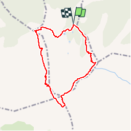
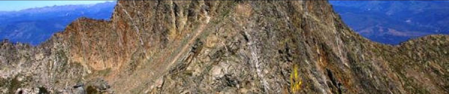
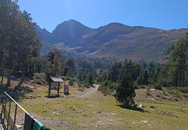
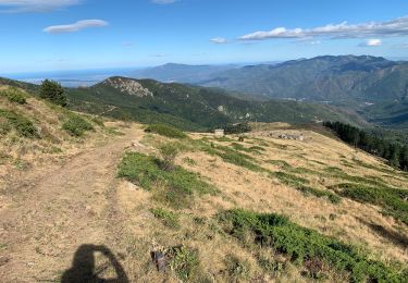
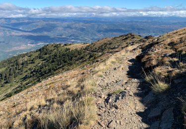
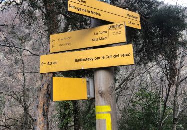
Une superbe randonnée qui nous mène vers le sommet mythique des Catalans, le Pic du Canigou. En boucle en partant du chalet des Cortalets, on passe au Pic Joffre puis au Pic du Canigou avant de redescendre par la cheminée Sud vers le porteille de Valmanya pour remonter au Pic Barbet et de redescendre par la crête jusqu'au refuge. D’autres informations et photos sont disponibles ICI Balade inspirée par le site « Les Balades et Randonnées de Fred »
Ort
Kommentare
Touren in der Umgebung
![Tour Wandern Taurinya - le Canigou depuis le col de Millères - Photo](https://media.geolcdn.com/t/375/260/ext.jpg?maxdim=2&url=https%3A%2F%2Fstatic1.geolcdn.com%2Fsiteimages%2Fupload%2Ffiles%2F1553511878bg_sport_marche.png)
![Wandern Wandern](https://static1.geolcdn.com/sitytour/trail-icons/101.png)
Wandern
![](/images/other/stat-length.png)
![](https://static1.geolcdn.com/siteimages/upload/files/16400158638029165_repeat_loop_refresh_sync_direction_icon.png)
![Tour Wandern Taurinya - b - Photo](https://media.geolcdn.com/t/375/260/3dd340e8-99b2-41f7-a00f-44f941b5bfec.jpg&format=jpg&maxdim=2)
![Wandern Wandern](https://static1.geolcdn.com/sitytour/trail-icons/101.png)
Wandern
![](/images/other/stat-length.png)
![](https://static1.geolcdn.com/siteimages/upload/files/16400158638029165_repeat_loop_refresh_sync_direction_icon.png)
![Tour sport Valmanya - 20241013 Los Masos-Prat Cabrera… - Photo](https://media.geolcdn.com/t/375/260/31e31d29-0e6a-46e9-9786-fccc3cfba894.jpg&format=jpg&maxdim=2)
sport
![](/images/other/stat-length.png)
![](https://static1.geolcdn.com/siteimages/upload/files/16400158638029165_repeat_loop_refresh_sync_direction_icon.png)
![Tour Wandern Taurinya - les mines du Salver - Photo](https://media.geolcdn.com/t/375/260/d4f6c8be-7332-4c2c-bb83-4fdf39739546.jpg&format=jpg&maxdim=2)
![Wandern Wandern](https://static1.geolcdn.com/sitytour/trail-icons/101.png)
Wandern
![](/images/other/stat-length.png)
![](https://static1.geolcdn.com/siteimages/upload/files/16400158638029165_repeat_loop_refresh_sync_direction_icon.png)
![Tour Wandern Taurinya - Jour 3 Pic du Canigou - Photo](https://media.geolcdn.com/t/375/260/4a654063-9e7f-4694-8336-f9269fb3df08.jpg&format=jpg&maxdim=2)
![Wandern Wandern](https://static1.geolcdn.com/sitytour/trail-icons/101.png)
Wandern
![](/images/other/stat-length.png)
![](https://static1.geolcdn.com/siteimages/upload/files/16400158638029165_repeat_loop_refresh_sync_direction_icon.png)
![Tour Wandern Casteil - Jour 2 Pic du Canigou - Photo](https://media.geolcdn.com/t/375/260/638d215b-fce6-4508-ac14-7470431b6327.jpg&format=jpg&maxdim=2)
![Wandern Wandern](https://static1.geolcdn.com/sitytour/trail-icons/101.png)
Wandern
![](/images/other/stat-length.png)
![](https://static1.geolcdn.com/siteimages/upload/files/16400158638029165_repeat_loop_refresh_sync_direction_icon.png)
![Tour Wandern Taurinya - 2022 TRANSPYRÉNÉENNE : refuge les Mariales le Canigou - les Cortalets - Refuge Bardera - Photo](https://media.geolcdn.com/t/375/260/34d0ca19-8985-4b27-87e8-d2fc7f767174.jpg&format=jpg&maxdim=2)
![Wandern Wandern](https://static1.geolcdn.com/sitytour/trail-icons/101.png)
Wandern
![](/images/other/stat-length.png)
![](https://static1.geolcdn.com/siteimages/upload/files/16400158638029165_repeat_loop_refresh_sync_direction_icon.png)
![Tour Wandern Casteil - 2022 TRANSPYRÉNÉENNE : refuge des Marieles - Le Canihou- refuge des Cortalets - Photo](https://media.geolcdn.com/t/375/260/6854f852-cc25-4812-86bc-a58f423a6f1a.jpg&format=jpg&maxdim=2)
![Wandern Wandern](https://static1.geolcdn.com/sitytour/trail-icons/101.png)
Wandern
![](/images/other/stat-length.png)
![](https://static1.geolcdn.com/siteimages/upload/files/16400158638029165_repeat_loop_refresh_sync_direction_icon.png)
![Tour Wandern Estoher - 20220227 Mas Maler- Mines de la Coume - Photo](https://media.geolcdn.com/t/375/260/94957a20-6255-4ff8-a701-35b976e1181d.jpg&format=jpg&maxdim=2)
![Wandern Wandern](https://static1.geolcdn.com/sitytour/trail-icons/101.png)
Wandern
![](/images/other/stat-length.png)
![](https://static1.geolcdn.com/siteimages/upload/files/16400158638029165_repeat_loop_refresh_sync_direction_icon.png)
super