![](/images/other/stat-length.png)
![Tour Mountainbike Sommières - Le raid Vidourle 2002 - Photo](https://media.geolcdn.com/t/1900/400/ext.pjpeg?maxdim=2&url=https%3A%2F%2Fservices.sitytrail.com%2FGeolivesWS%2FDownloadMedia.ashx%3FTrailID%3D100960%26Media%3D459_1.jpg)
Le raid Vidourle 2002
tracegps
Benutzer
![Länge](/images/other/stat-length.png)
Länge
39 km
![Maximale Höhe](https://static1.geolcdn.com/siteimages/upload/files/1508320355ic_sort_altitude_max_24dp.png)
Maximale Höhe
102 m
![Positive Höhendifferenz](https://static1.geolcdn.com/siteimages/upload/files/1508320355ic_sort_den_pos_24dp.png)
Positive Höhendifferenz
550 m
![Km-Effort](/images/other/stat-length.png)
Km-Effort
47 km
![Min. Höhe](https://static1.geolcdn.com/siteimages/upload/files/1508320355ic_sort_altitude_min_24dp.png)
Min. Höhe
28 m
![Negative Höhendifferenz](https://static1.geolcdn.com/siteimages/upload/files/1508320355ic_sort_den_neg_24dp.png)
Negative Höhendifferenz
569 m
![Boucle](https://static1.geolcdn.com/siteimages/upload/files/16400158638029165_repeat_loop_refresh_sync_direction_icon.png)
Boucle
Nein
Erstellungsdatum :
2014-12-10 00:00:00.0
Letzte Änderung :
2014-12-10 00:00:00.0
![Mountainbike](https://static1.geolcdn.com/sitytour/trail-icons/202.png)
2h30
Schwierigkeit : Schwierig
![Scannen Sie diesen QR-Code, um die Tour in der SityTrail-Anwendung zu öffnen](https://capi.geolives.com/qq0zvz2zws4bq2lad0pu/sitytour/trails/100960/qr.png?size=200)
Kostenlosegpshiking-Anwendung
Über SityTrail
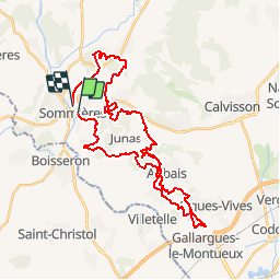
Tour Mountainbike von 39 km verfügbar auf Okzitanien, Gard, Sommières. Diese Tour wird von tracegps vorgeschlagen.
Beschreibung
C'était le 07 Octobre 2005 que le village de Sommières, dans le département du Gard, accueillait l'édition 2005 du Raid Vidourle VTT organisé par Latitude VTT. Visible ICI
Ort
Land:
France
Region :
Okzitanien
Abteilung/Provinz :
Gard
Kommune :
Sommières
Standort:
Unknown
Gehen Sie:(Dec)
Gehen Sie:(UTM)
587967 ; 4848255 (31T) N.
Kommentare
Touren in der Umgebung
![Tour Wandern Sommières - SOMMIERES 30 - VILLEVIEILLE châteaux- JUNAS les carrières - Photo](https://media.geolcdn.com/t/375/260/ext.jpg?maxdim=2&url=https%3A%2F%2Fservices.sitytrail.com%2FGeolivesWS%2FDownloadMedia.ashx%3FTrailID%3D421587%26Media%3D20150516132041.jpg)
![Wandern Wandern](https://static1.geolcdn.com/sitytour/trail-icons/101.png)
SOMMIERES 30 - VILLEVIEILLE châteaux- JUNAS les carrières
Wandern
Medium
(2)
Sommières,
Okzitanien,
Gard,
France
![](/images/other/stat-length.png)
14 km | 16,9 km-effort
2h 34min
![](https://static1.geolcdn.com/siteimages/upload/files/16400158638029165_repeat_loop_refresh_sync_direction_icon.png)
Ja
![Tour Wandern Saussines - Saussines - Photo](https://media.geolcdn.com/t/375/260/ext.jpg?maxdim=2&url=https%3A%2F%2Fstatic1.geolcdn.com%2Fsiteimages%2Fupload%2Ffiles%2F1553511878bg_sport_marche.png)
![Wandern Wandern](https://static1.geolcdn.com/sitytour/trail-icons/101.png)
Saussines
Wandern
Sehr leicht
(1)
Saussines,
Okzitanien,
Hérault,
France
![](/images/other/stat-length.png)
13,3 km | 14,9 km-effort
4h 13min
![](https://static1.geolcdn.com/siteimages/upload/files/16400158638029165_repeat_loop_refresh_sync_direction_icon.png)
Ja
![Tour Wandern Junas - Entre Junas et Aujargues - Photo](https://media.geolcdn.com/t/375/260/ext.jpg?maxdim=2&url=https%3A%2F%2Fservices.sitytrail.com%2FGeolivesWS%2FDownloadMedia.ashx%3FTrailID%3D243757%26Media%3Dfix__20140120160354.jpg)
![Wandern Wandern](https://static1.geolcdn.com/sitytour/trail-icons/101.png)
Entre Junas et Aujargues
Wandern
Einfach
Junas,
Okzitanien,
Gard,
France
![](/images/other/stat-length.png)
7,9 km | 9,4 km-effort
2h 2min
![](https://static1.geolcdn.com/siteimages/upload/files/16400158638029165_repeat_loop_refresh_sync_direction_icon.png)
Ja
![Tour Wandern Sommières - Autour de Villevielle 30 - Photo](https://media.geolcdn.com/t/375/260/ext.jpg?maxdim=2&url=https%3A%2F%2Fstatic1.geolcdn.com%2Fsiteimages%2Fupload%2Ffiles%2F1553511878bg_sport_marche.png)
![Wandern Wandern](https://static1.geolcdn.com/sitytour/trail-icons/101.png)
Autour de Villevielle 30
Wandern
Einfach
(2)
Sommières,
Okzitanien,
Gard,
France
![](/images/other/stat-length.png)
10,5 km | 12,3 km-effort
3h 0min
![](https://static1.geolcdn.com/siteimages/upload/files/16400158638029165_repeat_loop_refresh_sync_direction_icon.png)
Ja
![Tour Wandern Sommières - Les boucles du Vidourle - Photo](https://media.geolcdn.com/t/375/260/60623f25-e960-4316-892a-026a76081c35.jpg&format=jpg&maxdim=2)
![Wandern Wandern](https://static1.geolcdn.com/sitytour/trail-icons/101.png)
Les boucles du Vidourle
Wandern
Schwierig
Sommières,
Okzitanien,
Gard,
France
![](/images/other/stat-length.png)
13 km | 15,5 km-effort
3h 30min
![](https://static1.geolcdn.com/siteimages/upload/files/16400158638029165_repeat_loop_refresh_sync_direction_icon.png)
Ja
![Tour Wandern Aspères - Aspères - Photo](https://media.geolcdn.com/t/375/260/3aa1cad7-a037-4103-94ea-4f508e99c3ef.jpg&format=jpg&maxdim=2)
![Wandern Wandern](https://static1.geolcdn.com/sitytour/trail-icons/101.png)
![Tour Wandern Saussines - Circuit des capot elles - Photo](https://media.geolcdn.com/t/375/260/6f4a9959-1f02-425b-b581-c3419555dbfc.jpg&format=jpg&maxdim=2)
![Wandern Wandern](https://static1.geolcdn.com/sitytour/trail-icons/101.png)
Circuit des capot elles
Wandern
Schwierig
Saussines,
Okzitanien,
Hérault,
France
![](/images/other/stat-length.png)
11,7 km | 13,4 km-effort
3h 56min
![](https://static1.geolcdn.com/siteimages/upload/files/16400158638029165_repeat_loop_refresh_sync_direction_icon.png)
Ja
![Tour sport Junas - Carrières de Jonas - Photo](https://media.geolcdn.com/t/375/260/32e42789-febd-4072-a1cf-d057581247ef.jpg&format=jpg&maxdim=2)
Carrières de Jonas
sport
Sehr leicht
Junas,
Okzitanien,
Gard,
France
![](/images/other/stat-length.png)
3,5 km | 4,1 km-effort
Unbekannt
![](https://static1.geolcdn.com/siteimages/upload/files/16400158638029165_repeat_loop_refresh_sync_direction_icon.png)
Ja
![Tour Elektrofahrrad Junas - Boucle de la Vidourle - Photo](https://media.geolcdn.com/t/375/260/bfea6d61-9a81-4c7f-8a65-551fef99e67d.jpg&format=jpg&maxdim=2)
![Elektrofahrrad Elektrofahrrad](https://static1.geolcdn.com/sitytour/trail-icons/205.png)
Boucle de la Vidourle
Elektrofahrrad
Einfach
Junas,
Okzitanien,
Gard,
France
![](/images/other/stat-length.png)
38 km | 43 km-effort
2h 33min
![](https://static1.geolcdn.com/siteimages/upload/files/16400158638029165_repeat_loop_refresh_sync_direction_icon.png)
Ja
Belle piste, seulement le tracé est encombré par la végétation, attention ! (juillet 2015)